TopoQuest Logo
Do you find TopoQuest useful?
Help keep TopoQuest running and adding new maps/features by donating!
Bitcoin:  19c7KJd3qBynnjoSw5npx9KScwjBe4ifkT
Litecoin:  LXs6TkuXGGXo1vDsWCkWVdjQX94eUKd6ui
Home View Maps Find Maps Find Places Resources & Links


Lambert, Tennessee Topographic Map

USGS Map Title: Lambert, TN
USGS Map MRC: 35089C4
DRG (GeoTIFF) Download: o35089c4.tif


Neighboring USGS Topographic Map Quads:


  Mason, TN  
35089D5
 

  Stanton, TN  
35089D4
 

  Dancyville, TN  
35089D3
 

  Gallaway, TN  
35089C5
 

  Lambert, TN  
35089C4
 

  Laconia, TN  
35089C3
 

  Oakland, TN  
35089B5
 

  Macon, TN  
35089B4
 

  Somerville, TN  
35089B3


Map MRC Location:

N36°
W90°
N36°
W89°
H8 H7 H6 H5 H4 H3 H2 H1
G8 G7 G6 G5 G4 G3 G2 G1
F8 F7 F6 F5 F4 F3 F2 F1
E8 E7 E6 E5 E4 E3 E2 E1
D8 D7 D6 D5 D4 D3 D2 D1
C8 C7 C6 C5 C4 C3 C2 C1
B8 B7 B6 B5 B4 B3 B2 B1
A8 A7 A6 A5 A4 A3 A2 A1
N35°
W90°
N35°
W89°

Lambert, TN USGS 1:24K Topographic Map Preview:
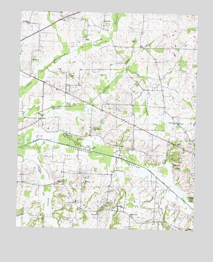
Lambert, TN USGS Topographic Map
Click on map above to begin viewing in our Map Viewer.

This topographic map contains these locations and features:
Feature Name Type Latitude Longitude GNIS ID View Map
Antioch ChurchChurchN35.2656°W89.4590°1275798View Map
Baskerville CemeteryCemeteryN35.3590°W89.4209°1276426View Map
Basswood CreekStreamN35.3415°W89.4276°1276441View Map
Belmont ChurchChurchN35.3684°W89.4945°1276979View Map
Bernard SchoolSchoolN35.3698°W89.4409°1277046View Map
Brewer SchoolSchoolN35.3406°W89.4704°1278303View Map
Carter CemeteryCemeteryN35.2795°W89.4526°1279786View Map
Carter ChapelChurchN35.2768°W89.4529°1319799View Map
Carter SchoolSchoolN35.2768°W89.4526°1279820View Map
Commissioner District 3CivilN35.3291°W89.4869°2464141View Map
Cypress BottomBasinN35.3490°W89.4698°1281917View Map
Feathers ChapelPopulated PlaceN35.2576°W89.4201°1647504View Map
Feathers ChapelChurchN35.2584°W89.4204°1284179View Map
Glade Springs SchoolSchoolN35.3118°W89.3892°1285479View Map
Green HollowSwampN35.3587°W89.4551°1286103View Map
Harwell CemeteryCemeteryN35.3673°W89.4417°1287081View Map
Hill School (historical)SchoolN35.3206°W89.4837°1319838View Map
Hood CemeteryCemeteryN35.2637°W89.4387°1288224View Map
Jones CreekStreamN35.2748°W89.3937°1289781View Map
Lake RooneyReservoirN35.2867°W89.3889°1300049View Map
LambertPopulated PlaceN35.3129°W89.4845°1315349View Map
Lambert School (historical)SchoolN35.3126°W89.4879°1319850View Map
Laurel BottomBasinN35.3243°W89.4479°1290686View Map
Laurel Creek CanalCanalN35.3209°W89.4581°1290733View Map
Loosahatchie BottomBasinN35.2912°W89.4387°1269766View Map
Maclin Quarter CemeteryCemeteryN35.3704°W89.4681°1292457View Map
Mason CemeteryCemeteryN35.3468°W89.4918°1292881View Map
Mays School (historical)SchoolN35.3087°W89.4467°1319855View Map
MoormanPopulated PlaceN35.3112°W89.3876°1294330View Map
North Fayette County Volunteer Fire DepartmentBuildingN35.3420°W89.4391°2653628View Map
Oak Grove ChurchChurchN35.3145°W89.3906°1296084View Map
Patterson CemeteryCemeteryN35.3381°W89.4642°1296938View Map
Pulliams ChapelChurchN35.3118°W89.3887°1319899View Map
Rhea ChapelChurchN35.3076°W89.4470°1299270View Map
Stafford CemeteryCemeteryN35.2573°W89.4990°1271186View Map
The MountainSummitN35.2687°W89.3770°1272415View Map
Travelers Rest SchoolSchoolN35.2629°W89.4254°1304153View Map
Treadville BottomBasinN35.2715°W89.4776°1272853View Map
Warren SchoolSchoolN35.2587°W89.4429°1304384View Map
Williamson CemeteryCemeteryN35.3390°W89.4426°1274725View Map
Williamson ChurchChurchN35.3598°W89.4351°1274726View Map
Winfrey LakeReservoirN35.2918°W89.3884°1301728View Map
Winfrey Lake DamDamN35.2918°W89.3884°1301729View Map

Note: Coordinates in the location and feature list above are referenced to NAD83 datum.


Copyright (C) 2008-2024 Ryan Niemi / Sunset Dynamics ... All Rights Reserved