TopoQuest Logo
Do you find TopoQuest useful?
Help keep TopoQuest running and adding new maps/features by donating!
Bitcoin:  19c7KJd3qBynnjoSw5npx9KScwjBe4ifkT
Litecoin:  LXs6TkuXGGXo1vDsWCkWVdjQX94eUKd6ui
Home View Maps Find Maps Find Places Resources & Links


Darlington, Indiana Topographic Map

USGS Map Title: Darlington, IN
USGS Map MRC: 40086A7
DRG (GeoTIFF) Download: o40086a7.tif


Neighboring USGS Topographic Map Quads:


  Linden, IN  
40086B8
 

  Kirkpatrick, IN  
40086B7
 

  Colfax, IN  
40086B6
 

  Crawfordsville, IN  
40086A8
 

  Darlington, IN  
40086A7
 

  Shannondale, IN  
40086A6
 

  New Market, IN  
39086H8
 

  Ladoga, IN  
39086H7
 

  New Ross, IN  
39086H6


Map MRC Location:

N41°
W87°
N41°
W86°
H8 H7 H6 H5 H4 H3 H2 H1
G8 G7 G6 G5 G4 G3 G2 G1
F8 F7 F6 F5 F4 F3 F2 F1
E8 E7 E6 E5 E4 E3 E2 E1
D8 D7 D6 D5 D4 D3 D2 D1
C8 C7 C6 C5 C4 C3 C2 C1
B8 B7 B6 B5 B4 B3 B2 B1
A8 A7 A6 A5 A4 A3 A2 A1
N40°
W87°
N40°
W86°

Darlington, IN USGS 1:24K Topographic Map Preview:
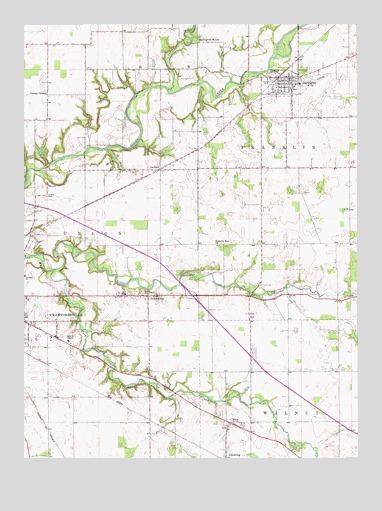
Darlington, IN USGS Topographic Map
Click on map above to begin viewing in our Map Viewer.

This topographic map contains these locations and features:
Feature Name Type Latitude Longitude GNIS ID View Map
CrawfordsvillePopulated PlaceN40.0412°W86.8745°433103View Map
DarlingtonPopulated PlaceN40.1100°W86.7720°433318View Map
Darlington Fire DepartmentBuildingN40.1093°W86.7759°2626268View Map
Darlington WoodsPopulated PlaceN40.1198°W86.8053°433319View Map
GarfieldPopulated PlaceN40.0831°W86.8239°434956View Map
Gravelly Run ChurchChurchN40.0614°W86.8025°435361View Map
Greenlawn CemeteryCemeteryN40.1117°W86.7679°435441View Map
Honey CreekStreamN40.1120°W86.7825°436383View Map
Hutton CemeteryCemeteryN40.0759°W86.8665°436665View Map
LinnsburgPopulated PlaceN40.0003°W86.8000°437967View Map
Little Sugar CreekStreamN40.0545°W86.8642°438154View Map
Lye CreekStreamN40.1062°W86.8208°438423View Map
MacePopulated PlaceN40.0103°W86.7964°438449View Map
Ropkey FieldAirportN40.0583°W86.7962°2717334View Map
SmartsburgPopulated PlaceN40.0470°W86.8286°449731View Map
Town of DarlingtonCivilN40.1074°W86.7768°2396679View Map
Township of FranklinCivilN40.0867°W86.7508°453309View Map
Youngs ChapelChurchN40.1053°W86.8667°446416View Map

Note: Coordinates in the location and feature list above are referenced to NAD83 datum.


Copyright (C) 2008-2024 Ryan Niemi / Sunset Dynamics ... All Rights Reserved