TopoQuest Logo
Do you find TopoQuest useful?
Help keep TopoQuest running and adding new maps/features by donating!
Bitcoin:  19c7KJd3qBynnjoSw5npx9KScwjBe4ifkT
Litecoin:  LXs6TkuXGGXo1vDsWCkWVdjQX94eUKd6ui
Home View Maps Find Maps Find Places Resources & Links


Daviston, Alabama Topographic Map

USGS Map Title: Daviston, AL
USGS Map MRC: 33085A6
DRG (GeoTIFF) Download: o33085a6.tif


Neighboring USGS Topographic Map Quads:


  Gibsonville, AL  
33085B7
 

  Mellow Valley, AL  
33085B6
 

  Wadley North, AL  
33085B5
 

  New Site, AL  
33085A7
 

  Daviston, AL  
33085A6
 

  Wadley South, AL  
33085A5
 

  Jacksons Gap, AL  
32085H7
 

  Buttston, AL  
32085H6
 

  Dudleyville, AL  
32085H5


Map MRC Location:

N34°
W86°
N34°
W85°
H8 H7 H6 H5 H4 H3 H2 H1
G8 G7 G6 G5 G4 G3 G2 G1
F8 F7 F6 F5 F4 F3 F2 F1
E8 E7 E6 E5 E4 E3 E2 E1
D8 D7 D6 D5 D4 D3 D2 D1
C8 C7 C6 C5 C4 C3 C2 C1
B8 B7 B6 B5 B4 B3 B2 B1
A8 A7 A6 A5 A4 A3 A2 A1
N33°
W86°
N33°
W85°

Daviston, AL USGS 1:24K Topographic Map Preview:
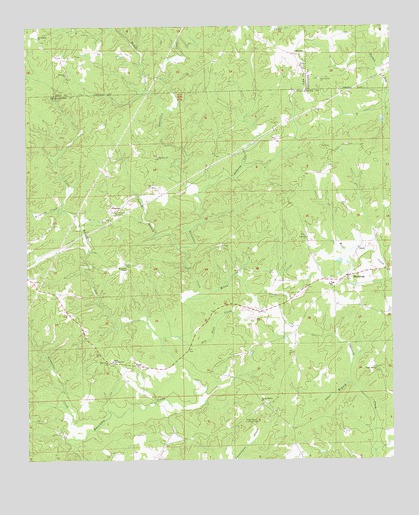
Daviston, AL USGS Topographic Map
Click on map above to begin viewing in our Map Viewer.

This topographic map contains these locations and features:
Feature Name Type Latitude Longitude GNIS ID View Map
Bethany CemeteryCemeteryN33.1118°W85.7352°1805369View Map
Bethany Primitive Baptist ChurchChurchN33.1112°W85.7363°113995View Map
Birdsong CreekStreamN33.0723°W85.7383°114372View Map
Coger Hill ChurchChurchN33.0262°W85.6302°116366View Map
County Line Baptist ChurchChurchN33.1101°W85.6494°116731View Map
County Line CemeteryCemeteryN33.1098°W85.6494°1805726View Map
DavistonPopulated PlaceN33.0529°W85.6397°117144View Map
Daviston Baptist ChurchChurchN33.0546°W85.6380°158685View Map
Daviston CemeteryCemeteryN33.0554°W85.6386°1730347View Map
Daviston CemeteryCemeteryN33.0523°W85.6463°137397View Map
Daviston High SchoolSchoolN33.0507°W85.6452°137398View Map
Daviston Methodist ChurchChurchN33.0521°W85.6469°137399View Map
Daviston Post OfficePost OfficeN33.0527°W85.6399°168013View Map
Daviston Volunteer Fire DepartmentBuildingN33.0527°W85.6404°2691473View Map
Dipping Vat CreekStreamN33.0754°W85.6919°117295View Map
Emuckfaw (historical)Populated PlaceN33.0879°W85.6855°150039View Map
Emuckfaw Battleground (historical)LocaleN33.0162°W85.7047°137415View Map
Gin Pond CreekStreamN33.0357°W85.6986°118998View Map
Grapevine CreekStreamN33.0062°W85.7341°119246View Map
Hodges CreekStreamN33.1007°W85.7030°120175View Map
Ingram BranchStreamN33.0607°W85.6986°120689View Map
Jones BranchStreamN33.0218°W85.6391°120979View Map
Leander ChurchChurchN33.0640°W85.6544°121448View Map
Little Emuckfaw CreekStreamN33.0346°W85.7044°121787View Map
McGuires ChapelChurchN33.0560°W85.7163°122558View Map
Milam CemeteryCemeteryN33.0554°W85.6791°122720View Map
Milam CreekStreamN33.0468°W85.6952°122721View Map
MotleyPopulated PlaceN33.1171°W85.6588°156742View Map
Mount Pisgah ChurchChurchN33.1218°W85.7463°123343View Map
Mount Zion ChurchChurchN33.0876°W85.7052°123477View Map
Mountain ChurchChurchN33.1171°W85.7394°163640View Map
Mountain School (historical)SchoolN33.1218°W85.7458°139678View Map
New Site DivisionCivilN33.0393°W85.7406°165968View Map
Oak Grove ChurchChurchN33.0282°W85.7225°124091View Map
Old Vickers CemeteryCemeteryN33.0712°W85.7205°152805View Map
Rocky Mount Lookout TowerTowerN33.0121°W85.6750°164406View Map
Rocky Mount Primitive Baptist ChurchChurchN33.0165°W85.6683°158915View Map
SimpsonPopulated PlaceN33.0718°W85.7219°157066View Map
Town of DavistonCivilN33.0557°W85.6371°2406360View Map
Union Baptist ChurchChurchN33.1129°W85.6561°164139View Map
Union CemeteryCemeteryN33.1134°W85.6547°1805415View Map
ZanaPopulated PlaceN33.0271°W85.7127°157291View Map
Zana (historical)Populated PlaceN33.0282°W85.7211°167966View Map
Zana Training SchoolSchoolN33.0287°W85.7211°129320View Map

Note: Coordinates in the location and feature list above are referenced to NAD83 datum.


Copyright (C) 2008-2025 Ryan Niemi / Sunset Dynamics ... All Rights Reserved