TopoQuest Logo
Do you find TopoQuest useful?
Help keep TopoQuest running and adding new maps/features by donating!
Bitcoin:  19c7KJd3qBynnjoSw5npx9KScwjBe4ifkT
Litecoin:  LXs6TkuXGGXo1vDsWCkWVdjQX94eUKd6ui
Home View Maps Find Maps Find Places Resources & Links


Wadley South, Alabama Topographic Map

USGS Map Title: Wadley South, AL
USGS Map MRC: 33085A5
DRG (GeoTIFF) Download: o33085a5.tif


Neighboring USGS Topographic Map Quads:


  Mellow Valley, AL  
33085B6
 

  Wadley North, AL  
33085B5
 

  Roanoke West, AL  
33085B4
 

  Daviston, AL  
33085A6
 

  Wadley South, AL  
33085A5
 

  Milltown, AL  
33085A4
 

  Buttston, AL  
32085H6
 

  Dudleyville, AL  
32085H5
 

  Lafayette, AL  
32085H4


Map MRC Location:

N34°
W86°
N34°
W85°
H8 H7 H6 H5 H4 H3 H2 H1
G8 G7 G6 G5 G4 G3 G2 G1
F8 F7 F6 F5 F4 F3 F2 F1
E8 E7 E6 E5 E4 E3 E2 E1
D8 D7 D6 D5 D4 D3 D2 D1
C8 C7 C6 C5 C4 C3 C2 C1
B8 B7 B6 B5 B4 B3 B2 B1
A8 A7 A6 A5 A4 A3 A2 A1
N33°
W86°
N33°
W85°

Wadley South, AL USGS 1:24K Topographic Map Preview:
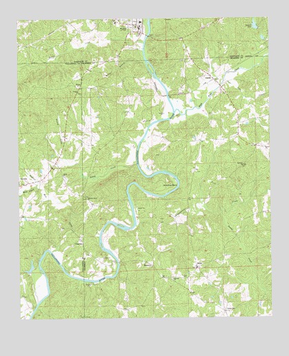
Wadley South, AL USGS Topographic Map
Click on map above to begin viewing in our Map Viewer.

This topographic map contains these locations and features:
Feature Name Type Latitude Longitude GNIS ID View Map
AbandaPopulated PlaceN33.1010°W85.5297°112879View Map
Abanda Baptist ChurchChurchN33.0985°W85.5263°151020View Map
Abanda CemeteryCemeteryN33.0934°W85.5211°136008View Map
Abanda Census Designated PlaceCensusN33.0926°W85.5253°2582661View Map
Abanda Fire and RescueBuildingN33.1002°W85.5278°2691611View Map
Antioch ChurchChurchN33.0946°W85.5958°113154View Map
Bailey CemeteryCemeteryN33.0607°W85.5363°136011View Map
Beulah CemeteryCemeteryN33.0940°W85.5838°136014View Map
Beulah ChurchChurchN33.0957°W85.5952°137373View Map
Bibby Family CemeteryCemeteryN33.0293°W85.5925°147435View Map
Bibbys FerryCrossingN33.0235°W85.5761°158783View Map
Bishop Ferry (historical)CrossingN33.1001°W85.5677°136015View Map
BlakePopulated PlaceN33.1140°W85.5008°140192View Map
BosworthPopulated PlaceN33.0229°W85.5613°156100View Map
Carlisle BranchStreamN33.1229°W85.5622°115622View Map
Caty CreekStreamN33.0976°W85.5247°115708View Map
Chesnut Fork ChurchChurchN33.1221°W85.5300°140204View Map
Chikasanoxee CreekStreamN33.0504°W85.5544°151731View Map
Clegg and Pearson DamDamN33.1151°W85.5016°131219View Map
Clegg and Pearson LakeReservoirN33.1166°W85.5030°131220View Map
Concord DamDamN33.1201°W85.5050°131227View Map
Concord LakeReservoirN33.1220°W85.5068°116504View Map
Darian CemeteryCemeteryN33.0593°W85.6022°137396View Map
Darian Primitive Baptist ChurchChurchN33.0596°W85.6030°117075View Map
Denny Ferry (historical)CrossingN33.0737°W85.5633°136033View Map
Denver ChurchChurchN33.0007°W85.5933°117237View Map
Ebenezer CemeteryCemeteryN33.0365°W85.5399°136035View Map
Ebenezer ChurchChurchN33.0160°W85.5488°117823View Map
Fredrick Ferry (historical)CrossingN33.0062°W85.6152°158992View Map
Frog EyePopulated PlaceN33.0326°W85.5941°156385View Map
Greasy CreekStreamN33.0654°W85.6016°119313View Map
High Pine CreekStreamN33.0862°W85.5483°120058View Map
Hodnett Mill CreekStreamN33.0279°W85.6088°120181View Map
Hopewell CemeteryCemeteryN33.0634°W85.5130°1805666View Map
Hopewell ChurchChurchN33.0637°W85.5133°120374View Map
Hutton CreekStreamN33.1157°W85.5638°120606View Map
Johnson Ferry (historical)CrossingN33.0510°W85.5569°136063View Map
Laney CreekStreamN33.0643°W85.5669°121379View Map
LouinaPopulated PlaceN33.1246°W85.5522°156631View Map
Mill CreekStreamN33.0548°W85.6158°155151View Map
Milltown DivisionCivilN33.0401°W85.5149°165684View Map
Monaghan DamDamN33.0201°W85.6183°131153View Map
Monaghan LakeReservoirN33.0196°W85.6205°131154View Map
Mountain Spring ChurchChurchN33.0504°W85.5919°123527View Map
Mountain Springs CemeteryCemeteryN33.0504°W85.5922°147448View Map
Muleshoe BendBendN33.0562°W85.5541°123582View Map
Pleasant Grove ChurchChurchN33.0023°W85.5236°163384View Map
Rocky BranchStreamN33.1060°W85.5627°125799View Map
Sandy CreekStreamN33.0432°W85.5250°126379View Map
ShilohPopulated PlaceN33.0210°W85.5366°157051View Map
Shiloh Baptist ChurchChurchN33.0212°W85.5369°151025View Map
Shiloh CemeteryCemeteryN33.0204°W85.5377°1805678View Map
Sims CemeteryCemeteryN33.0171°W85.5438°153450View Map
Sparkling SpringsLocaleN33.0687°W85.5866°136088View Map
Town of WadleyCivilN33.1239°W85.5683°2406813View Map
TruettPopulated PlaceN33.0971°W85.5952°157173View Map
Union HillPopulated PlaceN33.0029°W85.5227°128329View Map
WadleyPopulated PlaceN33.1215°W85.5663°128488View Map
Wadley CemeteryCemeteryN33.1243°W85.5750°1805719View Map
Wadley High SchoolSchoolN33.1235°W85.5761°135827View Map
Wadley Police DepartmentBuildingN33.1218°W85.5646°2751860View Map
Wadley Post OfficePost OfficeN33.1204°W85.5642°167903View Map
Wadley Volunteer Fire DepartmentBuildingN33.1205°W85.5641°2683027View Map
Wait Ferry (historical)CrossingN33.0421°W85.5561°136103View Map

Note: Coordinates in the location and feature list above are referenced to NAD83 datum.


Copyright (C) 2008-2025 Ryan Niemi / Sunset Dynamics ... All Rights Reserved