TopoQuest Logo
Do you find TopoQuest useful?
Help keep TopoQuest running and adding new maps/features by donating!
Bitcoin:  19c7KJd3qBynnjoSw5npx9KScwjBe4ifkT
Litecoin:  LXs6TkuXGGXo1vDsWCkWVdjQX94eUKd6ui
Home View Maps Find Maps Find Places Resources & Links


Davisville, Alabama Topographic Map

USGS Map Title: Davisville, AL
USGS Map MRC: 32085C6
DRG (GeoTIFF) Download: o32085c6.tif


Neighboring USGS Topographic Map Quads:


  La Place, AL  
32085D7
 

  Tuskegee, AL  
32085D6
 

  Little Texas, AL  
32085D5
 

  Hardaway, AL  
32085C7
 

  Davisville, AL  
32085C6
 

  Warriorstand, AL  
32085C5
 

  Thompson, AL  
32085B7
 

  Union Springs, AL  
32085B6
 

  Roba, AL  
32085B5


Map MRC Location:

N33°
W86°
N33°
W85°
H8 H7 H6 H5 H4 H3 H2 H1
G8 G7 G6 G5 G4 G3 G2 G1
F8 F7 F6 F5 F4 F3 F2 F1
E8 E7 E6 E5 E4 E3 E2 E1
D8 D7 D6 D5 D4 D3 D2 D1
C8 C7 C6 C5 C4 C3 C2 C1
B8 B7 B6 B5 B4 B3 B2 B1
A8 A7 A6 A5 A4 A3 A2 A1
N32°
W86°
N32°
W85°

Davisville, AL USGS 1:24K Topographic Map Preview:
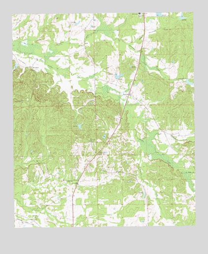
Davisville, AL USGS Topographic Map
Click on map above to begin viewing in our Map Viewer.

This topographic map contains these locations and features:
Feature Name Type Latitude Longitude GNIS ID View Map
Bethlehem CemeteryCemeteryN32.2818°W85.6755°154812View Map
Bethlehem ChurchChurchN32.2818°W85.6761°114127View Map
Cloud CemeteryCemeteryN32.3390°W85.6805°116276View Map
Cotton ValleyPopulated PlaceN32.2929°W85.6922°116689View Map
Cotton Valley Church (historical)ChurchN32.2771°W85.7052°134006View Map
Cotton Valley School (historical)SchoolN32.2782°W85.7055°134007View Map
DavisvillePopulated PlaceN32.3276°W85.6697°117145View Map
Fort CemeteryCemeteryN32.2926°W85.6905°118515View Map
Fort Davis DivisionCivilN32.2929°W85.7373°165858View Map
Fort Hull ChurchChurchN32.3563°W85.7002°118521View Map
Fort Hull School (historical)SchoolN32.3535°W85.6944°134016View Map
H A Vaughn Junior Number 1 DamDamN32.3701°W85.6333°130490View Map
Howard DamDamN32.3351°W85.6766°130451View Map
Howard Lamar DamDamN32.3335°W85.6266°130448View Map
Lake RussellReservoirN32.3092°W85.7040°130406View Map
Lake WadsworthReservoirN32.3445°W85.7477°130461View Map
Liberty Hill (historical)LocaleN32.3265°W85.7375°134029View Map
Liberty Hill CemeteryCemeteryN32.3243°W85.7444°163790View Map
Liberty Hill ChurchChurchN32.3499°W85.7183°163791View Map
Liberty Hill ChurchChurchN32.3240°W85.7444°121573View Map
Liberty Hill School (historical)SchoolN32.3240°W85.7438°134030View Map
Ligon CemeteryCemeteryN32.3201°W85.6583°163792View Map
Little Acorn CreekStreamN32.2807°W85.6327°121686View Map
Little Persimmon CreekStreamN32.3568°W85.6697°121838View Map
Macon AcademySchoolN32.3746°W85.6619°122186View Map
Mount AndrewPopulated PlaceN32.3446°W85.7361°156743View Map
Mount Andrew ChurchChurchN32.3421°W85.7361°134036View Map
Mount Andrews CemeteryCemeteryN32.3424°W85.7366°163794View Map
Mount Nebo Baptist ChurchChurchN32.3271°W85.6691°163795View Map
Mount Nebo CemeteryCemeteryN32.3432°W85.6644°123262View Map
Mount Nebo School (historical)SchoolN32.3274°W85.6694°134039View Map
Old Hog Wallow LakeReservoirN32.3725°W85.6326°130489View Map
Ostette DamDamN32.2718°W85.6583°130366View Map
Persimmon CreekStreamN32.3518°W85.7386°152875View Map
Pine Grove ChurchChurchN32.2771°W85.7100°124786View Map
Prairie CreekStreamN32.3004°W85.6641°153058View Map
Saint Mark Baptist ChurchChurchN32.2568°W85.7341°155228View Map
Saint Mark CemeteryCemeteryN32.2565°W85.7347°154814View Map
Shiloh CemeteryCemeteryN32.3526°W85.6613°154816View Map
Shiloh ChurchChurchN32.3543°W85.6600°126736View Map
Spring Hill ChurchChurchN32.2999°W85.6966°127255View Map
Tallassarr CreekStreamN32.2976°W85.6569°127645View Map
Tysons LakeReservoirN32.3341°W85.6284°130447View Map
W M Russell Junior DamDamN32.3101°W85.7050°130405View Map
W T Wadsworth DamDamN32.3435°W85.7466°130462View Map
Whitlow CemeteryCemeteryN32.2943°W85.6374°163803View Map

Note: Coordinates in the location and feature list above are referenced to NAD83 datum.


Copyright (C) 2008-2025 Ryan Niemi / Sunset Dynamics ... All Rights Reserved