TopoQuest Logo
Do you find TopoQuest useful?
Help keep TopoQuest running and adding new maps/features by donating!
Bitcoin:  19c7KJd3qBynnjoSw5npx9KScwjBe4ifkT
Litecoin:  LXs6TkuXGGXo1vDsWCkWVdjQX94eUKd6ui
Home View Maps Find Maps Find Places Resources & Links


Dayton, Missouri Topographic Map

USGS Map Title: Dayton, MO
USGS Map MRC: 38094D2
DRG (GeoTIFF) Download: o38094d2.tif


Neighboring USGS Topographic Map Quads:


  Austin, MO  
38094E3
 

  Garden City, MO  
38094E2
 

  Quick City, MO  
38094E1
 

  Adrian, MO  
38094D3
 

  Dayton, MO  
38094D2
 

  Creighton, MO  
38094D1
 

  Butler, MO  
38094C3
 

  Spruce, MO  
38094C2
 

  Johnstown, MO  
38094C1


Map MRC Location:

N39°
W95°
N39°
W94°
H8 H7 H6 H5 H4 H3 H2 H1
G8 G7 G6 G5 G4 G3 G2 G1
F8 F7 F6 F5 F4 F3 F2 F1
E8 E7 E6 E5 E4 E3 E2 E1
D8 D7 D6 D5 D4 D3 D2 D1
C8 C7 C6 C5 C4 C3 C2 C1
B8 B7 B6 B5 B4 B3 B2 B1
A8 A7 A6 A5 A4 A3 A2 A1
N38°
W95°
N38°
W94°

Dayton, MO USGS 1:24K Topographic Map Preview:
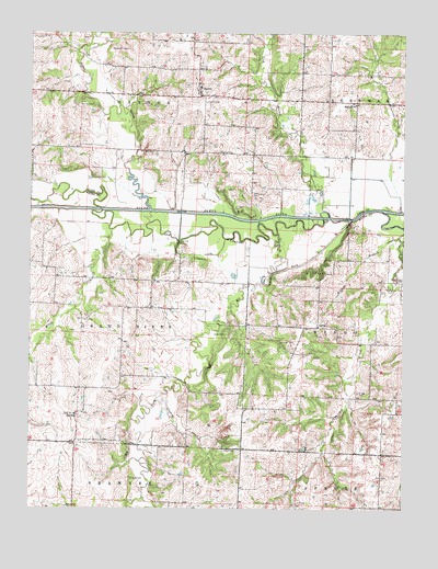
Dayton, MO USGS Topographic Map
Click on map above to begin viewing in our Map Viewer.

This topographic map contains these locations and features:
Feature Name Type Latitude Longitude GNIS ID View Map
AaronPopulated PlaceN38.4231°W94.1538°740612View Map
Aaron Post Office (historical)Post OfficeN38.4222°W94.1542°2091668View Map
AltonaPopulated PlaceN38.3997°W94.2349°713254View Map
Altona School (historical)SchoolN38.4000°W94.2322°746000View Map
Blackburn CemeteryCemeteryN38.4958°W94.2183°714319View Map
Bryan School (historical)SchoolN38.4045°W94.1344°745999View Map
Choctaw School (historical)SchoolN38.4686°W94.1830°729859View Map
Cloud CemeteryCemeteryN38.3906°W94.1858°716010View Map
Cooney CreekStreamN38.4034°W94.2055°729864View Map
Crawford School (historical)SchoolN38.4284°W94.2136°745997View Map
DaytonPopulated PlaceN38.4853°W94.1938°716755View Map
Dayton School (historical)SchoolN38.4850°W94.1947°745941View Map
Earheart CemeteryCemeteryN38.4189°W94.1619°717239View Map
Elk ForkStreamN38.4509°W94.1433°717458View Map
France CemeteryCemeteryN38.3828°W94.2166°718158View Map
Gragg CemeteryCemeteryN38.4056°W94.1405°718652View Map
Highland School (historical)SchoolN38.4814°W94.1413°719577View Map
Leos Angus Ranch Airport (historical)AirportN38.4800°W94.1974°758654View Map
Lick BranchStreamN38.4534°W94.1519°736316View Map
Lost CreekStreamN38.4539°W94.1261°721583View Map
Lost Creek CemeteryCemeteryN38.4892°W94.1366°721591View Map
McKinley School (historical)SchoolN38.4278°W94.1538°745998View Map
Mingo CreekStreamN38.4483°W94.2227°722436View Map
Owen CemeteryCemeteryN38.4211°W94.1849°723902View Map
Peter CreekStreamN38.4464°W94.1266°724252View Map
Peter Creek CemeteryCemeteryN38.4358°W94.1258°724253View Map
Pulliam CemeteryCemeteryN38.4811°W94.2338°724990View Map
Sugar CreekStreamN38.4536°W94.2099°727225View Map
Township of Grand RiverCivilN38.4227°W94.2348°766294View Map

Note: Coordinates in the location and feature list above are referenced to NAD83 datum.


Copyright (C) 2008-2024 Ryan Niemi / Sunset Dynamics ... All Rights Reserved