TopoQuest Logo
Do you find TopoQuest useful?
Help keep TopoQuest running and adding new maps/features by donating!
Bitcoin:  19c7KJd3qBynnjoSw5npx9KScwjBe4ifkT
Litecoin:  LXs6TkuXGGXo1vDsWCkWVdjQX94eUKd6ui
Home View Maps Find Maps Find Places Resources & Links


Austin, Missouri Topographic Map

USGS Map Title: Austin, MO
USGS Map MRC: 38094E3
DRG (GeoTIFF) Download: o38094e3.tif


Neighboring USGS Topographic Map Quads:


  Peculiar, MO  
38094F4
 

  Harrisonville, MO  
38094F3
 

  East Lynne, MO  
38094F2
 

  Everett, MO  
38094E4
 

  Austin, MO  
38094E3
 

  Garden City, MO  
38094E2
 

  Main City, MO  
38094D4
 

  Adrian, MO  
38094D3
 

  Dayton, MO  
38094D2


Map MRC Location:

N39°
W95°
N39°
W94°
H8 H7 H6 H5 H4 H3 H2 H1
G8 G7 G6 G5 G4 G3 G2 G1
F8 F7 F6 F5 F4 F3 F2 F1
E8 E7 E6 E5 E4 E3 E2 E1
D8 D7 D6 D5 D4 D3 D2 D1
C8 C7 C6 C5 C4 C3 C2 C1
B8 B7 B6 B5 B4 B3 B2 B1
A8 A7 A6 A5 A4 A3 A2 A1
N38°
W95°
N38°
W94°

Austin, MO USGS 1:24K Topographic Map Preview:
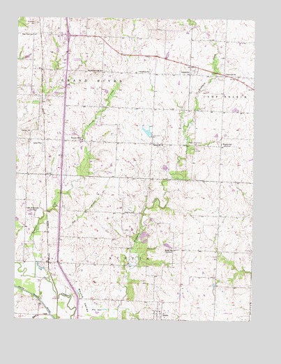
Austin, MO USGS Topographic Map
Click on map above to begin viewing in our Map Viewer.

This topographic map contains these locations and features:
Feature Name Type Latitude Longitude GNIS ID View Map
AustinPopulated PlaceN38.5028°W94.2999°713492View Map
Austin School (historical)SchoolN38.5028°W94.2963°745932View Map
Belle Plain SchoolSchoolN38.6178°W94.3669°713925View Map
Black CreekStreamN38.5014°W94.3563°714287View Map
Bodenhammer HillSummitN38.6017°W94.3338°714471View Map
Cook Lake DamDamN38.5867°W94.2602°763340View Map
DaughertyPopulated PlaceN38.6036°W94.2816°716680View Map
Eightmile School (historical)SchoolN38.6020°W94.2655°717424View Map
Elm BranchStreamN38.5361°W94.3639°717497View Map
Elm Branch School (historical)SchoolN38.5458°W94.3694°717507View Map
Emrick HillSummitN38.5772°W94.3699°717588View Map
Harrisonville South Wastewater Treatment PlantLocaleN38.6036°W94.3537°2477726View Map
Hartzler LakeReservoirN38.5779°W94.3059°763140View Map
Hartzler Lake DamDamN38.5750°W94.3036°763139View Map
Houston School (historical)SchoolN38.5731°W94.2672°719900View Map
Hutchison School (historical)SchoolN38.6031°W94.3113°720052View Map
J A Tobin Construction Company DamDamN38.5333°W94.3086°763451View Map
J A Tobin Construction Company LakeReservoirN38.5333°W94.3086°763452View Map
Kurzweil LakeReservoirN38.5632°W94.2966°763454View Map
Kurzweil Lake DamDamN38.5633°W94.2952°763453View Map
Lawrence Smith Memorial AirportAirportN38.6152°W94.3429°742789View Map
Lone TreePopulated PlaceN38.5722°W94.3611°721485View Map
Lone Tree School (historical)SchoolN38.5742°W94.3688°745930View Map
Mound ValleyValleyN38.5025°W94.3333°722701View Map
Mullin School (historical)SchoolN38.5295°W94.2927°729932View Map
Pleasant Ridge ChurchChurchN38.5745°W94.3402°724588View Map
Pleasant Ridge School (historical)SchoolN38.5778°W94.3405°745929View Map
Pleasant Valley CemeteryCemeteryN38.5733°W94.2844°724614View Map
Reed CemeteryCemeteryN38.5703°W94.2824°725184View Map
Rural Home (historical)Populated PlaceN38.5720°W94.3733°1829042View Map
School Number 36 (historical)SchoolN38.5728°W94.3030°755395View Map
Snowball HillSummitN38.6228°W94.3655°726675View Map
Tennessee CreekStreamN38.5156°W94.3566°727531View Map
Township of AustinCivilN38.5125°W94.3220°766431View Map
Township of Grand RiverCivilN38.6115°W94.3675°766438View Map
Union Hall School (historical)SchoolN38.5445°W94.3194°745931View Map
Vansandt CemeteryCemeteryN38.5445°W94.3183°728145View Map

Note: Coordinates in the location and feature list above are referenced to NAD83 datum.


Copyright (C) 2008-2024 Ryan Niemi / Sunset Dynamics ... All Rights Reserved