TopoQuest Logo
Do you find TopoQuest useful?
Help keep TopoQuest running and adding new maps/features by donating!
Bitcoin:  19c7KJd3qBynnjoSw5npx9KScwjBe4ifkT
Litecoin:  LXs6TkuXGGXo1vDsWCkWVdjQX94eUKd6ui
Home View Maps Find Maps Find Places Resources & Links


Decatur, Texas Topographic Map

USGS Map Title: Decatur, TX
USGS Map MRC: 33097B5
DRG (GeoTIFF) Download: o33097b5.tif


Neighboring USGS Topographic Map Quads:


  Alvord, TX  
33097C6
 

  Pecan Creek, TX  
33097C5
 

  Slidell, TX  
33097C4
 

  Bridgeport East, TX  
33097B6
 

  Decatur, TX  
33097B5
 

  Bluett, TX  
33097B4
 

  Cottondale, TX  
33097A6
 

  Boyd, TX  
33097A5
 

  Rhome, TX  
33097A4


Map MRC Location:

N34°
W98°
N34°
W97°
H8 H7 H6 H5 H4 H3 H2 H1
G8 G7 G6 G5 G4 G3 G2 G1
F8 F7 F6 F5 F4 F3 F2 F1
E8 E7 E6 E5 E4 E3 E2 E1
D8 D7 D6 D5 D4 D3 D2 D1
C8 C7 C6 C5 C4 C3 C2 C1
B8 B7 B6 B5 B4 B3 B2 B1
A8 A7 A6 A5 A4 A3 A2 A1
N33°
W98°
N33°
W97°

Decatur, TX USGS 1:24K Topographic Map Preview:
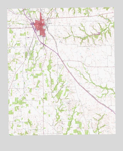
Decatur, TX USGS Topographic Map
Click on map above to begin viewing in our Map Viewer.

This topographic map contains these locations and features:
Feature Name Type Latitude Longitude GNIS ID View Map
Annaville CemeteryCemeteryN33.1262°W97.5650°1329561View Map
Bell ChurchChurchN33.2446°W97.5995°1330371View Map
Bethel CemeteryCemeteryN33.2473°W97.6220°1330488View Map
Catholic Church of the AssumptionChurchN33.2248°W97.6042°2024862View Map
Center CreekStreamN33.1901°W97.6023°1332524View Map
Church of ChristChurchN33.2121°W97.5981°2024866View Map
City of DecaturCivilN33.2276°W97.5899°2410307View Map
Cornerstone Church of the NazareneChurchN33.2351°W97.5950°2024867View Map
DecaturPopulated PlaceN33.2343°W97.5861°1373362View Map
Decatur Baptist College Administration BuildingBuildingN33.2229°W97.5867°2031336View Map
Decatur City HallBuildingN33.2351°W97.5852°2753659View Map
Decatur City Public WorksBuildingN33.2225°W97.5874°2630813View Map
Decatur CollegeSchoolN33.2232°W97.5864°1334171View Map
Decatur Elementary SchoolSchoolN33.2251°W97.6045°2009286View Map
Decatur Fire DepartmentBuildingN33.2330°W97.5852°2551461View Map
Decatur High SchoolSchoolN33.2218°W97.5998°2009287View Map
Decatur Intermediate SchoolSchoolN33.2321°W97.5842°2009288View Map
Decatur Learning CenterSchoolN33.2296°W97.5834°2009289View Map
Decatur Middle SchoolSchoolN33.2187°W97.5998°2009290View Map
Decatur Police DepartmentBuildingN33.2223°W97.5874°2630812View Map
Decatur Police DepartmentBuildingN33.2234°W97.5874°2655948View Map
Eagle Drive Baptist ChurchChurchN33.2185°W97.6006°2024854View Map
Eagle StadiumParkN33.2329°W97.5823°2027906View Map
First United Pentecostal Church of DecaturChurchN33.2376°W97.5942°2024869View Map
Flat Bush AirportAirportN33.1324°W97.6070°2676609View Map
HermanPopulated PlaceN33.1673°W97.5325°1378442View Map
LifeStar 4 - Southwest Helicopters - DecaturBuildingN33.2183°W97.5936°2655819View Map
Mc Entire AirportAirportN33.1450°W97.6030°1386526View Map
New Salem ChurchChurchN33.1790°W97.6195°1342511View Map
Pat Dick HillSummitN33.1560°W97.5536°1343649View Map
Pleasant Grove Church Number 1ChurchN33.1610°W97.5850°1344202View Map
Primera Iglesia Bautista ChurchChurchN33.2357°W97.5895°2024860View Map
Red Ace Ranch Airport (historical)AirportN33.2418°W97.6211°1386520View Map
Saint John ChurchChurchN33.2401°W97.5767°1345935View Map
Sand Hill CemeteryCemeteryN33.1726°W97.5559°1346519View Map
Sand Hill ChurchChurchN33.1746°W97.5617°1346521View Map
Soil Conservation Service Site 24 DamDamN33.2251°W97.5170°1857176View Map
Soil Conservation Service Site 24 ReservoirReservoirN33.2251°W97.5170°1857177View Map
Texas Tourist CampLocaleN33.2285°W97.5761°2032013View Map
Waggoner MansionBuildingN33.2343°W97.5773°2032496View Map
Wise County Constable's Office Precinct 1BuildingN33.2328°W97.5875°2739164View Map
Wise County Emergency Medical ServicesBuildingN33.2358°W97.5990°2656200View Map
Wise County Heritage MuseumBuildingN33.2243°W97.5867°2014359View Map
Wise County JailBuildingN33.2320°W97.6108°2738707View Map
Wise County Sheriff's OfficeBuildingN33.2324°W97.6107°2738968View Map
Wise Regional Health System East CampusHospitalN33.2177°W97.5933°2718948View Map
Wise Regional Health System West CampusHospitalN33.2178°W97.5977°2015657View Map

Note: Coordinates in the location and feature list above are referenced to NAD83 datum.


Copyright (C) 2008-2025 Ryan Niemi / Sunset Dynamics ... All Rights Reserved