TopoQuest Logo
Do you find TopoQuest useful?
Help keep TopoQuest running and adding new maps/features by donating!
Bitcoin:  19c7KJd3qBynnjoSw5npx9KScwjBe4ifkT
Litecoin:  LXs6TkuXGGXo1vDsWCkWVdjQX94eUKd6ui
Home View Maps Find Maps Find Places Resources & Links


Delaney, Arkansas Topographic Map

USGS Map Title: Delaney, AR
USGS Map MRC: 35093G8
DRG (GeoTIFF) Download: o35093g8.tif


Neighboring USGS Topographic Map Quads:


  Sulphur City, AR  
35094H1
 

  Durham, AR  
35093H8
 

  Japton, AR  
35093H7
 

  Brentwood, AR  
35094G1
 

  Delaney, AR  
35093G8
 

  Saint Paul, AR  
35093G7
 

  Fern, AR  
35094F1
 

  Bidville, AR  
35093F8
 

  Cass, AR  
35093F7


Map MRC Location:

N36°
W94°
N36°
W93°
H8 H7 H6 H5 H4 H3 H2 H1
G8 G7 G6 G5 G4 G3 G2 G1
F8 F7 F6 F5 F4 F3 F2 F1
E8 E7 E6 E5 E4 E3 E2 E1
D8 D7 D6 D5 D4 D3 D2 D1
C8 C7 C6 C5 C4 C3 C2 C1
B8 B7 B6 B5 B4 B3 B2 B1
A8 A7 A6 A5 A4 A3 A2 A1
N35°
W94°
N35°
W93°

Delaney, AR USGS 1:24K Topographic Map Preview:
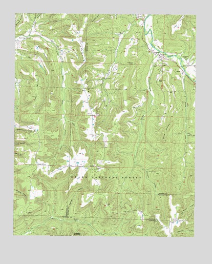
Delaney, AR USGS Topographic Map
Click on map above to begin viewing in our Map Viewer.

This topographic map contains these locations and features:
Feature Name Type Latitude Longitude GNIS ID View Map
Anderson KnobSummitN35.8473°W93.9183°70445View Map
Baker KnobSummitN35.8379°W93.8980°70491View Map
Boone MountainSummitN35.8040°W93.8966°70766View Map
BrannonPopulated PlaceN35.8179°W93.9463°70797View Map
Brannon ChurchChurchN35.8181°W93.9469°81345View Map
Brannon MountainSummitN35.8323°W93.9521°70798View Map
Brown MountainSummitN35.8540°W93.9780°70845View Map
Canner HollowValleyN35.7604°W93.9646°71002View Map
CrossesPopulated PlaceN35.8742°W93.9113°71291View Map
Crosses CreekStreamN35.8717°W93.9108°71292View Map
Crosses Creek ChurchChurchN35.8387°W93.9385°74383View Map
Crosses Creek School (historical)SchoolN35.8365°W93.9388°81347View Map
Dabney CreekStreamN35.8459°W93.8841°71326View Map
DelaneyPopulated PlaceN35.8523°W93.9002°71361View Map
Delaney CreekStreamN35.8548°W93.9008°71362View Map
Delaney Creek School (historical)SchoolN35.8001°W93.9163°81348View Map
Denny MountainSummitN35.8287°W93.9866°71367View Map
Dump Post Office (historical)Post OfficeN35.7845°W93.9877°84301View Map
Hazel ValleyPopulated PlaceN35.8612°W93.9924°71952View Map
Hazel Valley Post Office (historical)Post OfficeN35.8701°W93.9860°84308View Map
Hazel Valley School (historical)SchoolN35.8612°W93.9921°81337View Map
HealthPopulated PlaceN35.7892°W93.9430°71953View Map
Montgomery ChapelChurchN35.8506°W93.8821°72713View Map
Mountain CrestPopulated PlaceN35.7584°W93.8877°77763View Map
PatrickPopulated PlaceN35.8431°W93.8838°73013View Map
Peach BranchStreamN35.8626°W93.9908°73026View Map
Possum CreekStreamN35.8417°W93.8813°73168View Map
Possum Creek School (historical)SchoolN35.8137°W93.8810°81359View Map
Shepherd MountainSummitN35.7504°W93.9596°73533View Map
Stacy MountainSummitN35.8706°W93.8874°73683View Map
Stringum CemeteryCemeteryN35.7867°W93.9071°73741View Map
Stringum HollowValleyN35.7904°W93.9155°73742View Map
Sugar CreekStreamN35.8081°W93.8813°73752View Map
Temple HillLocaleN35.7901°W93.9838°73838View Map
Temple Hill CemeteryCemeteryN35.7629°W93.9910°78530View Map
Temple Hill ChurchChurchN35.7895°W93.9760°73839View Map
Temple Hill School (historical)SchoolN35.7890°W93.9838°81340View Map
Township of Independence (historical)CivilN35.8001°W93.9349°66401View Map
Township of ReedCivilN35.8293°W93.9863°69800View Map
Township of ValleyCivilN35.8525°W93.9187°68855View Map
Walls HollowValleyN35.8137°W93.9652°73992View Map
Wheeler GapGapN35.7637°W93.9210°74092View Map

Note: Coordinates in the location and feature list above are referenced to NAD83 datum.


Copyright (C) 2008-2024 Ryan Niemi / Sunset Dynamics ... All Rights Reserved