TopoQuest Logo
Do you find TopoQuest useful?
Help keep TopoQuest running and adding new maps/features by donating!
Bitcoin:  19c7KJd3qBynnjoSw5npx9KScwjBe4ifkT
Litecoin:  LXs6TkuXGGXo1vDsWCkWVdjQX94eUKd6ui
Home View Maps Find Maps Find Places Resources & Links


Japton, Arkansas Topographic Map

USGS Map Title: Japton, AR
USGS Map MRC: 35093H7
DRG (GeoTIFF) Download: o35093h7.tif


Neighboring USGS Topographic Map Quads:


  Goshen, AR  
36093A8
 

  Hartwell, AR  
36093A7
 

  Huntsville, AR  
36093A6
 

  Durham, AR  
35093H8
 

  Japton, AR  
35093H7
 

  Witter, AR  
35093H6
 

  Delaney, AR  
35093G8
 

  Saint Paul, AR  
35093G7
 

  Pettigrew, AR  
35093G6


Map MRC Location:

N36°
W94°
N36°
W93°
H8 H7 H6 H5 H4 H3 H2 H1
G8 G7 G6 G5 G4 G3 G2 G1
F8 F7 F6 F5 F4 F3 F2 F1
E8 E7 E6 E5 E4 E3 E2 E1
D8 D7 D6 D5 D4 D3 D2 D1
C8 C7 C6 C5 C4 C3 C2 C1
B8 B7 B6 B5 B4 B3 B2 B1
A8 A7 A6 A5 A4 A3 A2 A1
N35°
W94°
N35°
W93°

Japton, AR USGS 1:24K Topographic Map Preview:
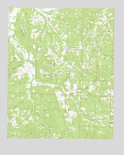
Japton, AR USGS Topographic Map
Click on map above to begin viewing in our Map Viewer.

This topographic map contains these locations and features:
Feature Name Type Latitude Longitude GNIS ID View Map
Accident School (historical)SchoolN35.9820°W93.7949°81343View Map
AsherPopulated PlaceN35.9426°W93.8505°70469View Map
Ball CreekStreamN35.9167°W93.8010°70499View Map
Ball Creek School (historical)SchoolN35.8931°W93.7782°81344View Map
Cedar HollowValleyN35.9995°W93.8596°71090View Map
Church of ChristChurchN35.8931°W93.7782°66393View Map
Church of ChristChurchN35.9184°W93.8021°66394View Map
Dunaway CemeteryCemeteryN35.9484°W93.8538°71469View Map
Dunaway HollowValleyN35.9206°W93.7855°71470View Map
Duncan CemeteryCemeteryN35.9978°W93.8216°71474View Map
Duncan School (historical)SchoolN35.9976°W93.8230°81349View Map
Eubanks MountainSummitN35.9515°W93.8196°71568View Map
Faulkner MountainSummitN35.9781°W93.8594°71602View Map
Ferrel Creek School (historical)SchoolN35.9906°W93.7546°81352View Map
Foster CreekStreamN35.9942°W93.8366°71666View Map
GeorgetownPopulated PlaceN35.9956°W93.8313°71747View Map
Good Hope School (historical)SchoolN35.8965°W93.8280°81353View Map
Good Luck School (historical)SchoolN35.9798°W93.8321°81354View Map
Grose CemeteryCemeteryN35.9351°W93.8202°71846View Map
Grose MountainSummitN35.9345°W93.8280°71847View Map
Hughes CreekStreamN35.9165°W93.8485°72115View Map
Jackson KnobSummitN35.9781°W93.7541°72165View Map
JaptonPopulated PlaceN35.9620°W93.8044°77366View Map
Japton Volunteer Fire DepartmentBuildingN35.9595°W93.8059°2116627View Map
Ledbetter CemeteryCemeteryN35.9034°W93.8044°72299View Map
Ledbetter MountainSummitN35.9056°W93.8096°72300View Map
Lollars Creek Farm AirportAirportN35.9365°W93.8430°83859View Map
McConnell BranchStreamN35.9023°W93.8449°72585View Map
McHenry BranchStreamN35.9765°W93.8674°72597View Map
Mossy CreekStreamN35.9970°W93.8230°72745View Map
Mountain Grove ChurchChurchN35.9337°W93.8010°72786View Map
Mountain Grove School (historical)SchoolN35.9337°W93.8010°81356View Map
Panther CreekStreamN35.9190°W93.8038°72986View Map
Panther KnobSummitN35.8890°W93.7510°72991View Map
Parker CemeteryCemeteryN35.9631°W93.8638°73000View Map
Parker HillSummitN35.9134°W93.7849°73001View Map
Potato KnobSummitN35.9523°W93.8696°73175View Map
Ridley HollowValleyN35.9476°W93.8566°73294View Map
Rowe HollowValleyN35.9279°W93.8513°73426View Map
Shooting CreekStreamN35.9712°W93.8738°73557View Map
Thomas CreekStreamN35.9315°W93.8416°73853View Map
Township of Ball Creek (historical)CivilN35.9167°W93.7905°66389View Map
Township of JaptonCivilN35.9530°W93.8022°68845View Map
Township of Union (historical)CivilN35.9334°W93.8377°66415View Map

Note: Coordinates in the location and feature list above are referenced to NAD83 datum.


Copyright (C) 2008-2024 Ryan Niemi / Sunset Dynamics ... All Rights Reserved