TopoQuest Logo
Do you find TopoQuest useful?
Help keep TopoQuest running and adding new maps/features by donating!
Bitcoin:  19c7KJd3qBynnjoSw5npx9KScwjBe4ifkT
Litecoin:  LXs6TkuXGGXo1vDsWCkWVdjQX94eUKd6ui
Home View Maps Find Maps Find Places Resources & Links


Delevan, New York Topographic Map

USGS Map Title: Delevan, NY
USGS Map MRC: 42078D4
DRG (GeoTIFF) Download: o42078d4.tif


Neighboring USGS Topographic Map Quads:


  Sardinia, NY  
42078E5
 

  Arcade, NY  
42078E4
 

  Bliss, NY  
42078E3
 

  West Valley, NY  
42078D5
 

  Delevan, NY  
42078D4
 

  Freedom, NY  
42078D3
 

  Ashford, NY  
42078C5
 

  Franklinville, NY  
42078C4
 

  Rawson, NY  
42078C3


Map MRC Location:

N43°
W79°
N43°
W78°
H8 H7 H6 H5 H4 H3 H2 H1
G8 G7 G6 G5 G4 G3 G2 G1
F8 F7 F6 F5 F4 F3 F2 F1
E8 E7 E6 E5 E4 E3 E2 E1
D8 D7 D6 D5 D4 D3 D2 D1
C8 C7 C6 C5 C4 C3 C2 C1
B8 B7 B6 B5 B4 B3 B2 B1
A8 A7 A6 A5 A4 A3 A2 A1
N42°
W79°
N42°
W78°

Delevan, NY USGS 1:24K Topographic Map Preview:
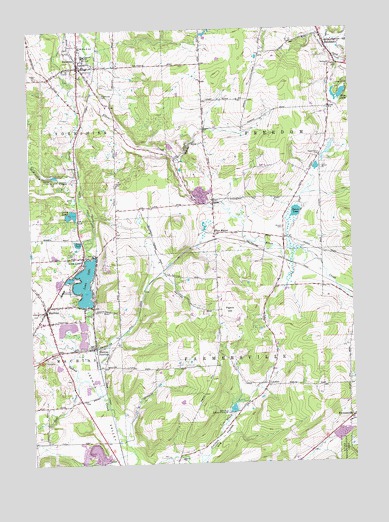
Delevan, NY USGS Topographic Map
Click on map above to begin viewing in our Map Viewer.

This topographic map contains these locations and features:
Feature Name Type Latitude Longitude GNIS ID View Map
Beaver LakeLakeN42.4473°W78.3964°943394View Map
Calvary Community ChapelChurchN42.4784°W78.4784°2597394View Map
Camp VickLocaleN42.4840°W78.3756°945675View Map
Dam Number TwoDamN42.3899°W78.4206°948004View Map
DelevanPopulated PlaceN42.4892°W78.4809°948273View Map
Delevan - Yorkshire Public LibraryBuildingN42.4917°W78.4792°2598253View Map
Delevan Baptist ChurchChurchN42.4897°W78.4783°2487198View Map
Delevan CemeteryCemeteryN42.4813°W78.4716°956458View Map
Delevan Elementary SchoolSchoolN42.4927°W78.4781°946296View Map
Delevan Fire Fighters TrainingBuildingN42.4961°W78.4774°2701164View Map
Delevan High School (historical)SchoolN42.4917°W78.4783°2487200View Map
Delevan Post OfficePost OfficeN42.4911°W78.4796°2598448View Map
Delevan United Methodist ChurchChurchN42.4891°W78.4793°2597399View Map
Delevan Volunteer Fire DepartmentBuildingN42.4883°W78.4811°2487197View Map
EltonPopulated PlaceN42.4509°W78.4289°949617View Map
Elton CemeteryCemeteryN42.4472°W78.4281°2554883View Map
Elton StationLocaleN42.4412°W78.4286°949619View Map
FarmersvillePopulated PlaceN42.3876°W78.3761°949916View Map
First Christian ChurchChurchN42.4183°W78.4937°2597409View Map
Freedom Post OfficePost OfficeN42.4970°W78.3854°2598453View Map
Frog PondLakeN42.4387°W78.4817°950753View Map
Gulf CreekStreamN42.3995°W78.4817°951918View Map
Hog HollowValleyN42.3757°W78.4358°952940View Map
Holy Family ChurchChurchN42.4942°W78.4800°2487201View Map
Hotel Delevan (historical)BuildingN42.4906°W78.4808°2487199View Map
King Memorial LibraryBuildingN42.4140°W78.4918°2598255View Map
Kingdom Hall of Jehovahs WitnessesChurchN42.3936°W78.4820°2598281View Map
LaidlawPopulated PlaceN42.3976°W78.4084°972700View Map
Lime LakePopulated PlaceN42.4345°W78.4797°955336View Map
Lime LakeReservoirN42.4274°W78.4792°955337View Map
Lime Lake Census Designated PlaceCensusN42.4327°W78.4808°2584273View Map
Lime Lake OutletStreamN42.4945°W78.4875°955338View Map
Lime Lake-Machias Census Designated Place (historical)CensusN42.4280°W78.4829°2390066View Map
Lucky LakesLakeN42.4465°W78.4853°956135View Map
MachiasPopulated PlaceN42.4195°W78.4945°956228View Map
Machias Census Designated PlaceCensusN42.4156°W78.4882°2584277View Map
Machias JunctionPopulated PlaceN42.4087°W78.4759°956229View Map
Machias Post OfficePost OfficeN42.4210°W78.4928°2598457View Map
Machias Volunteer Fire DepartmentBuildingN42.4148°W78.4909°2700833View Map
Maple Grove CemeteryCemeteryN42.4185°W78.4998°956407View Map
Maple Grove CemeteryCemeteryN42.4637°W78.3864°956408View Map
McKinstry CreekStreamN42.4606°W78.4822°956819View Map
New York State Police Troop A Zone 4 Machias StationBuildingN42.4224°W78.4924°2780756View Map
Pigeon HillSummitN42.4190°W78.4228°960374View Map
Saint Christophers ChurchChurchN42.4303°W78.4842°963429View Map
Saint Pius X SchoolSchoolN42.4953°W78.4797°964183View Map
SanduskyPopulated PlaceN42.4959°W78.3845°964418View Map
Sandusky Baptist ChurchChurchN42.4975°W78.3855°2597446View Map
Sandusky CemeteryCemeteryN42.4941°W78.3772°2554884View Map
Siloam CemeteryCemeteryN42.4427°W78.4018°965232View Map
Skim LakeLakeN42.4794°W78.3793°965353View Map
The Pines Healthcare and Rehabilitation Centers - Machias CampusBuildingN42.4246°W78.4870°2598468View Map
Town of FarmersvilleCivilN42.3929°W78.3865°978952View Map
Town of FreedomCivilN42.4783°W78.3771°978973View Map
Village of DelevanCivilN42.4913°W78.4796°2391636View Map

Note: Coordinates in the location and feature list above are referenced to NAD83 datum.


Copyright (C) 2008-2025 Ryan Niemi / Sunset Dynamics ... All Rights Reserved