TopoQuest Logo
Do you find TopoQuest useful?
Help keep TopoQuest running and adding new maps/features by donating!
Bitcoin:  19c7KJd3qBynnjoSw5npx9KScwjBe4ifkT
Litecoin:  LXs6TkuXGGXo1vDsWCkWVdjQX94eUKd6ui
Home View Maps Find Maps Find Places Resources & Links


Rawson, New York Topographic Map

USGS Map Title: Rawson, NY
USGS Map MRC: 42078C3
DRG (GeoTIFF) Download: o42078c3.tif


Neighboring USGS Topographic Map Quads:


  Delevan, NY  
42078D4
 

  Freedom, NY  
42078D3
 

  Houghton, NY  
42078D2
 

  Franklinville, NY  
42078C4
 

  Rawson, NY  
42078C3
 

  Black Creek, NY  
42078C2
 

  Hinsdale, NY  
42078B4
 

  Cuba, NY  
42078B3
 

  Friendship, NY  
42078B2


Map MRC Location:

N43°
W79°
N43°
W78°
H8 H7 H6 H5 H4 H3 H2 H1
G8 G7 G6 G5 G4 G3 G2 G1
F8 F7 F6 F5 F4 F3 F2 F1
E8 E7 E6 E5 E4 E3 E2 E1
D8 D7 D6 D5 D4 D3 D2 D1
C8 C7 C6 C5 C4 C3 C2 C1
B8 B7 B6 B5 B4 B3 B2 B1
A8 A7 A6 A5 A4 A3 A2 A1
N42°
W79°
N42°
W78°

Rawson, NY USGS 1:24K Topographic Map Preview:
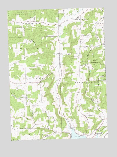
Rawson, NY USGS Topographic Map
Click on map above to begin viewing in our Map Viewer.

This topographic map contains these locations and features:
Feature Name Type Latitude Longitude GNIS ID View Map
AbbottsPopulated PlaceN42.2570°W78.3186°942120View Map
Abbotts CemeteryCemeteryN42.2572°W78.3177°2554912View Map
BellvillePopulated PlaceN42.3395°W78.2531°972219View Map
Bellville ChurchChurchN42.3345°W78.2503°943634View Map
Hardy CornersPopulated PlaceN42.3592°W78.3089°952221View Map
Hardys Corners CemeteryCemeteryN42.3616°W78.3042°2544280View Map
LyndonPopulated PlaceN42.3051°W78.3536°972443View Map
Lyndon Volunteer Fire CompanyBuildingN42.3053°W78.3503°2700942View Map
Lyons CornersPopulated PlaceN42.2673°W78.2533°956201View Map
RawsonPopulated PlaceN42.3215°W78.3086°962230View Map
Rawson CemeteryCemeteryN42.3314°W78.3097°2554914View Map
Rawson ChurchChurchN42.3320°W78.3097°962231View Map
Rawson CreekStreamN42.2603°W78.2981°962232View Map
Rawson ValleyValleyN42.2615°W78.2958°962234View Map
Strzelec FarmLocaleN42.3233°W78.3111°2703651View Map
Town of LyndonCivilN42.3052°W78.3628°979174View Map
Town of New HudsonCivilN42.3048°W78.2506°979266View Map
Wild Geese FarmLocaleN42.3717°W78.3053°2703662View Map

Note: Coordinates in the location and feature list above are referenced to NAD83 datum.


Copyright (C) 2008-2025 Ryan Niemi / Sunset Dynamics ... All Rights Reserved