TopoQuest Logo
Do you find TopoQuest useful?
Help keep TopoQuest running and adding new maps/features by donating!
Bitcoin:  19c7KJd3qBynnjoSw5npx9KScwjBe4ifkT
Litecoin:  LXs6TkuXGGXo1vDsWCkWVdjQX94eUKd6ui
Home View Maps Find Maps Find Places Resources & Links


Denmark, Mississippi Topographic Map

USGS Map Title: Denmark, MS
USGS Map MRC: 34089C3
DRG (GeoTIFF) Download: o34089c3.tif


Neighboring USGS Topographic Map Quads:


  Bagley Lake, MS  
34089D4
 

  Puskus Lake, MS  
34089D3
 

  Etta, MS  
34089D2
 

  Yocona, MS  
34089C4
 

  Denmark, MS  
34089C3
 

  Thaxton, MS  
34089C2
 

  Paris, MS  
34089B4
 

  Tula, MS  
34089B3
 

  Randolph, MS  
34089B2


Map MRC Location:

N35°
W90°
N35°
W89°
H8 H7 H6 H5 H4 H3 H2 H1
G8 G7 G6 G5 G4 G3 G2 G1
F8 F7 F6 F5 F4 F3 F2 F1
E8 E7 E6 E5 E4 E3 E2 E1
D8 D7 D6 D5 D4 D3 D2 D1
C8 C7 C6 C5 C4 C3 C2 C1
B8 B7 B6 B5 B4 B3 B2 B1
A8 A7 A6 A5 A4 A3 A2 A1
N34°
W90°
N34°
W89°

Denmark, MS USGS 1:24K Topographic Map Preview:
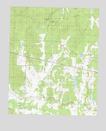
Denmark, MS USGS Topographic Map
Click on map above to begin viewing in our Map Viewer.

This topographic map contains these locations and features:
Feature Name Type Latitude Longitude GNIS ID View Map
Bluff Springs CampLocaleN34.3584°W89.3167°704817View Map
Bluff Springs CemeteryCemeteryN34.3601°W89.3178°706719View Map
Bluff Springs ChurchChurchN34.3587°W89.3181°692654View Map
Clear Springs ChurchChurchN34.3354°W89.2806°692932View Map
Concord Church (historical)ChurchN34.3379°W89.3659°704829View Map
CornishPopulated PlaceN34.2682°W89.3584°704831View Map
Cypress CemeteryCemeteryN34.3657°W89.2826°693031View Map
Cypress Watershed LT-14a-15 DamDamN34.3701°W89.2951°695574View Map
Cypress Watershed LT-14a-6 DamDamN34.3718°W89.2634°695575View Map
Denamrk ChurchChurchN34.3318°W89.3004°704836View Map
DenmarkPopulated PlaceN34.3109°W89.3467°693083View Map
Denmark LakeReservoirN34.3526°W89.3276°711514View Map
Denmark Lookout TowerTowerN34.3612°W89.3237°711226View Map
Denmark SchoolSchoolN34.3321°W89.3034°693084View Map
DogtownPopulated PlaceN34.2648°W89.2859°693095View Map
Dogtown School (historical)SchoolN34.2659°W89.2876°704837View Map
Drewery LakeReservoirN34.3471°W89.3367°711515View Map
East Cypress LakeReservoirN34.3736°W89.2612°711516View Map
East Kettle CreekStreamN34.2884°W89.3320°693149View Map
Goolsby LakeReservoirN34.3712°W89.3010°711517View Map
Granny BranchStreamN34.2521°W89.3165°693338View Map
Jackson Store (historical)LocaleN34.2768°W89.3154°704848View Map
Jones CemeteryCemeteryN34.3082°W89.2642°704851View Map
Jones CreekStreamN34.3034°W89.2695°693637View Map
Kettle CreekStreamN34.2612°W89.3420°693652View Map
Kettle LakeReservoirN34.3426°W89.2901°711518View Map
Lafayette County Volunteer Fire Department Station 11BuildingN34.3063°W89.2775°2666000View Map
Lafayette SpringsPopulated PlaceN34.3173°W89.2612°693678View Map
Lafayette Springs CemeteryCemeteryN34.3137°W89.2551°706727View Map
Lafayette Springs Primitive Baptist ChurchChurchN34.3171°W89.2579°706728View Map
Liberty Hill (historical)LocaleN34.3748°W89.2859°706729View Map
Liberty Hill ChurchChurchN34.3748°W89.2842°704857View Map
Little Kettle CreekStreamN34.2609°W89.3556°693769View Map
Midway CemeteryCemeteryN34.3315°W89.3737°704864View Map
Midway LakeReservoirN34.3314°W89.3568°711519View Map
Old Denmark (historical)LocaleN34.3237°W89.3529°706732View Map
Pine Bluff ChurchChurchN34.2593°W89.2592°704877View Map
Pinebluff School (historical)SchoolN34.2687°W89.2640°704878View Map
Price BridgeBridgeN34.2596°W89.3590°704880View Map
Sandy CreekStreamN34.2593°W89.3590°694711View Map
Shiloh Baptist ChurchChurchN34.3001°W89.2787°694768View Map
Shiloh CreekStreamN34.2637°W89.2767°694769View Map
Slack Ridge Church (historical)ChurchN34.2851°W89.3720°704889View Map
Slick CreekStreamN34.2504°W89.2640°694816View Map
Spring Hill CemeteryCemeteryN34.2998°W89.2503°704893View Map
Springdale CemeteryCemeteryN34.2695°W89.3173°706747View Map
Springdale ChurchChurchN34.2693°W89.3176°704895View Map
Supervisor District 1CivilN34.3229°W89.3675°711928View Map
Tan BranchStreamN34.2640°W89.2545°694937View Map
Unity SchoolSchoolN34.2762°W89.3165°695061View Map
Upper Yocona River Watershed Y-14-8 DamDamN34.2834°W89.2734°695561View Map
Upper Yocona River Watershed Y-14-8 DamDamN34.2884°W89.2534°695562View Map
Wildcat CreekStreamN34.2548°W89.3051°695175View Map
Wolf CreekStreamN34.2562°W89.3120°695204View Map
Y-14-3 DamDamN34.3518°W89.3284°695573View Map
Y-14-4 DamDamN34.3468°W89.3351°695572View Map
Yocona River Structure Y-14-2 DamDamN34.3284°W89.3067°695568View Map
Yocona Watershed Y-14-1 DamDamN34.3384°W89.2901°695571View Map
Yocona Watershed Y-14-17 DamDamN34.2634°W89.2551°695559View Map
Yocona Watershed Y-14-5 DamDamN34.3018°W89.3367°695563View Map
Yocona Watershed Y-14-6 DamDamN34.3318°W89.3567°695569View Map
Yocona Watershed Y-14-7 DamDamN34.3168°W89.2717°695566View Map

Note: Coordinates in the location and feature list above are referenced to NAD83 datum.


Copyright (C) 2008-2024 Ryan Niemi / Sunset Dynamics ... All Rights Reserved