TopoQuest Logo
Do you find TopoQuest useful?
Help keep TopoQuest running and adding new maps/features by donating!
Bitcoin:  19c7KJd3qBynnjoSw5npx9KScwjBe4ifkT
Litecoin:  LXs6TkuXGGXo1vDsWCkWVdjQX94eUKd6ui
Home View Maps Find Maps Find Places Resources & Links


Tula, Mississippi Topographic Map

USGS Map Title: Tula, MS
USGS Map MRC: 34089B3
DRG (GeoTIFF) Download: o34089b3.tif


Neighboring USGS Topographic Map Quads:


  Yocona, MS  
34089C4
 

  Denmark, MS  
34089C3
 

  Thaxton, MS  
34089C2
 

  Paris, MS  
34089B4
 

  Tula, MS  
34089B3
 

  Randolph, MS  
34089B2
 

  Banner, MS  
34089A4
 

  Sarepta, MS  
34089A3
 

  Robbs, MS  
34089A2


Map MRC Location:

N35°
W90°
N35°
W89°
H8 H7 H6 H5 H4 H3 H2 H1
G8 G7 G6 G5 G4 G3 G2 G1
F8 F7 F6 F5 F4 F3 F2 F1
E8 E7 E6 E5 E4 E3 E2 E1
D8 D7 D6 D5 D4 D3 D2 D1
C8 C7 C6 C5 C4 C3 C2 C1
B8 B7 B6 B5 B4 B3 B2 B1
A8 A7 A6 A5 A4 A3 A2 A1
N34°
W90°
N34°
W89°

Tula, MS USGS 1:24K Topographic Map Preview:
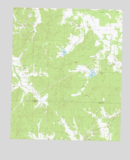
Tula, MS USGS Topographic Map
Click on map above to begin viewing in our Map Viewer.

This topographic map contains these locations and features:
Feature Name Type Latitude Longitude GNIS ID View Map
Antioch Church (historical)ChurchN34.1737°W89.2829°684332View Map
Blands (historical)LocaleN34.1946°W89.2584°684337View Map
Coon CreekStreamN34.2198°W89.2631°668799View Map
Coon Creek LakeReservoirN34.1883°W89.2836°668802View Map
Dallas (historical)LocaleN34.1973°W89.3106°684360View Map
McGlawin CreekStreamN34.2498°W89.2915°693918View Map
Missionary ChurchChurchN34.2337°W89.2995°673695View Map
Muckaloon CreekStreamN34.2498°W89.2959°674424View Map
Mullins Store (historical)LocaleN34.1929°W89.3631°684399View Map
New Antioch Church (historical)ChurchN34.1704°W89.2870°684400View Map
New El Bethel CemeteryCemeteryN34.1945°W89.3615°706731View Map
New Elbethel ChurchChurchN34.1943°W89.3615°674616View Map
Old Antioch ChurchChurchN34.1676°W89.2879°675158View Map
Old Dallas CemeteryCemeteryN34.1993°W89.3034°675178View Map
Old Sharp School (historical)SchoolN34.1940°W89.3623°706733View Map
Parker and Joyner Mill (historical)LocaleN34.1712°W89.3409°684418View Map
Possum BranchStreamN34.1904°W89.2851°676267View Map
PotlockneyPopulated PlaceN34.1751°W89.3737°706742View Map
Russell LakeReservoirN34.2085°W89.3164°676970View Map
Shady Grove ChurchChurchN34.1521°W89.3362°677588View Map
Spring HillPopulated PlaceN34.1973°W89.2570°706745View Map
Spring Hill ChurchChurchN34.1984°W89.2579°678134View Map
Springhill CemeteryCemeteryN34.1987°W89.2581°706748View Map
Stutson ChapelChurchN34.1893°W89.2715°678377View Map
Toccopola CreekStreamN34.2443°W89.2856°694987View Map
TulaPopulated PlaceN34.2329°W89.3623°678922View Map
Tula CemeteryCemeteryN34.2237°W89.3617°678923View Map
Valley Church (historical)ChurchN34.2268°W89.3331°684466View Map
Webb CemeteryCemeteryN34.1798°W89.3740°706750View Map
Yocona Watershed Y-14-14 DamDamN34.1901°W89.2817°682498View Map
Yocona Watershed Y-14-15 DamDamN34.2051°W89.3201°682502View Map
Yocona Watershed Y-14-16 DamDamN34.2334°W89.3501°682526View Map

Note: Coordinates in the location and feature list above are referenced to NAD83 datum.


Copyright (C) 2008-2025 Ryan Niemi / Sunset Dynamics ... All Rights Reserved