TopoQuest Logo
Do you find TopoQuest useful?
Help keep TopoQuest running and adding new maps/features by donating!
Bitcoin:  19c7KJd3qBynnjoSw5npx9KScwjBe4ifkT
Litecoin:  LXs6TkuXGGXo1vDsWCkWVdjQX94eUKd6ui
Home View Maps Find Maps Find Places Resources & Links


Thaxton, Mississippi Topographic Map

USGS Map Title: Thaxton, MS
USGS Map MRC: 34089C2
DRG (GeoTIFF) Download: o34089c2.tif


Neighboring USGS Topographic Map Quads:


  Puskus Lake, MS  
34089D3
 

  Etta, MS  
34089D2
 

  New Albany West, MS  
34089D1
 

  Denmark, MS  
34089C3
 

  Thaxton, MS  
34089C2
 

  Northwest Pontotoc, MS  
34089C1
 

  Tula, MS  
34089B3
 

  Randolph, MS  
34089B2
 

  Southwest Pontotoc, MS  
34089B1


Map MRC Location:

N35°
W90°
N35°
W89°
H8 H7 H6 H5 H4 H3 H2 H1
G8 G7 G6 G5 G4 G3 G2 G1
F8 F7 F6 F5 F4 F3 F2 F1
E8 E7 E6 E5 E4 E3 E2 E1
D8 D7 D6 D5 D4 D3 D2 D1
C8 C7 C6 C5 C4 C3 C2 C1
B8 B7 B6 B5 B4 B3 B2 B1
A8 A7 A6 A5 A4 A3 A2 A1
N34°
W90°
N34°
W89°

Thaxton, MS USGS 1:24K Topographic Map Preview:
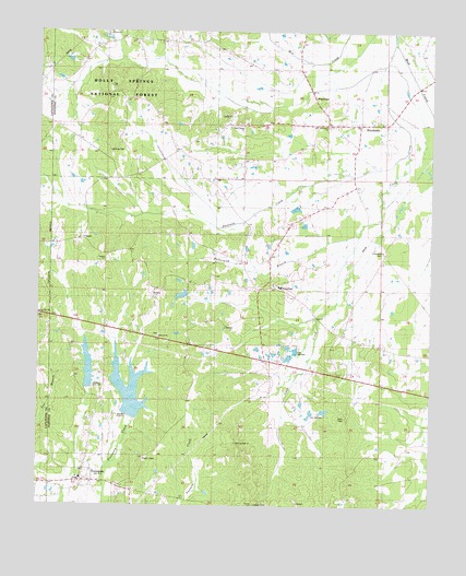
Thaxton, MS USGS Topographic Map
Click on map above to begin viewing in our Map Viewer.

This topographic map contains these locations and features:
Feature Name Type Latitude Longitude GNIS ID View Map
Bellvue ChurchChurchN34.2959°W89.2217°692537View Map
Bluff Springs ChurchChurchN34.2668°W89.1870°704908View Map
Bluff Springs School (historical)SchoolN34.2665°W89.1867°706850View Map
Buttermilk BranchStreamN34.3218°W89.1467°692786View Map
Cane CreekStreamN34.3726°W89.1359°692828View Map
Chester (historical)LocaleN34.2987°W89.1792°704909View Map
Chuckeheechabos CreekStreamN34.3723°W89.1373°704910View Map
County Line Church (historical)ChurchN34.2562°W89.2465°704832View Map
Cross Roads (historical)LocaleN34.3168°W89.1390°706869View Map
Crossroads ChurchChurchN34.3165°W89.1384°693018View Map
Duncans CreekStreamN34.3437°W89.1326°704911View Map
EsperanzaPopulated PlaceN34.3579°W89.1609°693184View Map
HurricanePopulated PlaceN34.3512°W89.1478°693562View Map
Hurricane ChurchChurchN34.3501°W89.1581°704912View Map
Hurricane School (historical)SchoolN34.3512°W89.1570°706886View Map
Hurricane Volunteer Fire DepartmentBuildingN34.3509°W89.1548°2665900View Map
Laodicea CemeteryCemeteryN34.3434°W89.2278°704913View Map
Lebanon Presbyterian ChurchChurchN34.2565°W89.2365°706887View Map
MacNeelys Tanyard (historical)LocaleN34.3529°W89.1987°704914View Map
Mogridge Lake DamDamN34.3051°W89.2034°695564View Map
Mount Peniel ChurchChurchN34.3062°W89.2115°694086View Map
Old Laodicea Primitive Baptist Church (historical)ChurchN34.3440°W89.2281°706900View Map
Ridge ChapelChurchN34.2818°W89.2370°694559View Map
Sand Spring ChurchChurchN34.3501°W89.1842°694698View Map
Sand Springs School (historical)SchoolN34.3501°W89.1851°706922View Map
Spring Hill ChurchChurchN34.2998°W89.2498°704894View Map
Supervisor District 2CivilN34.3003°W89.1480°712037View Map
ThaxtonPopulated PlaceN34.3076°W89.1781°694959View Map
Thaxton Baptist ChurchChurchN34.3079°W89.1731°706933View Map
Thaxton High School (historical)SchoolN34.3076°W89.1726°706934View Map
Thaxton Post OfficePost OfficeN34.2996°W89.1800°2768637View Map
Thaxton United Methodist ChurchChurchN34.3068°W89.1767°706935View Map
Thaxton Volunteer Fire DepartmentBuildingN34.3076°W89.1734°2665903View Map
ToccopolaPopulated PlaceN34.2565°W89.2356°694986View Map
Toccopola Baptist ChurchChurchN34.2562°W89.2356°706936View Map
Toccopola High School (historical)SchoolN34.2573°W89.2362°706937View Map
Toccopola Post OfficePost OfficeN34.2563°W89.2321°712909View Map
Toccopola United Methodist ChurchChurchN34.2593°W89.2328°706938View Map
Toccopola Volunteer Fire DepartmentBuildingN34.2569°W89.2362°2665904View Map
Town of ThaxtonCivilN34.3071°W89.1745°2406728View Map
Town of ToccopolaCivilN34.2561°W89.2211°2406740View Map
Union CemeteryCemeteryN34.3748°W89.2287°704916View Map
Union ChurchChurchN34.3745°W89.2284°695048View Map
Upper Yocona River Watershed Y-14-9 DamDamN34.2568°W89.2184°695558View Map

Note: Coordinates in the location and feature list above are referenced to NAD83 datum.


Copyright (C) 2008-2025 Ryan Niemi / Sunset Dynamics ... All Rights Reserved