TopoQuest Logo
Do you find TopoQuest useful?
Help keep TopoQuest running and adding new maps/features by donating!
Bitcoin:  19c7KJd3qBynnjoSw5npx9KScwjBe4ifkT
Litecoin:  LXs6TkuXGGXo1vDsWCkWVdjQX94eUKd6ui
Home View Maps Find Maps Find Places Resources & Links


Deposit, New York Topographic Map

USGS Map Title: Deposit, NY
USGS Map MRC: 42075A4
DRG (GeoTIFF) Download: o42075a4.tif


Neighboring USGS Topographic Map Quads:


  Afton, NY  
42075B5
 

  North Sanford, NY  
42075B4
 

  Trout Creek, NY  
42075B3
 

  Gulf Summit, NY  
42075A5
 

  Deposit, NY  
42075A4
 

  Cannonsville Reservoir, NY  
42075A3
 

  Susquehanna, PA  
41075H5
 

  Starrucca, PA  
41075H4
 

  Hancock, NY  
41075H3


Map MRC Location:

N43°
W76°
N43°
W75°
H8 H7 H6 H5 H4 H3 H2 H1
G8 G7 G6 G5 G4 G3 G2 G1
F8 F7 F6 F5 F4 F3 F2 F1
E8 E7 E6 E5 E4 E3 E2 E1
D8 D7 D6 D5 D4 D3 D2 D1
C8 C7 C6 C5 C4 C3 C2 C1
B8 B7 B6 B5 B4 B3 B2 B1
A8 A7 A6 A5 A4 A3 A2 A1
N42°
W76°
N42°
W75°

Deposit, NY USGS 1:24K Topographic Map Preview:
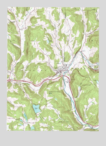
Deposit, NY USGS Topographic Map
Click on map above to begin viewing in our Map Viewer.

This topographic map contains these locations and features:
Feature Name Type Latitude Longitude GNIS ID View Map
Amendola Bluestone QuarryMineN42.1022°W75.4619°2564206View Map
Big HollowValleyN42.0672°W75.4223°943899View Map
Blueberry LakeLakeN42.0134°W75.4735°944339View Map
Bone CreekStreamN42.0581°W75.4285°944419View Map
Butler BrookStreamN42.0584°W75.4224°945338View Map
Cabin BrookStreamN42.1217°W75.3982°945414View Map
Cannonsville DamDamN42.0668°W75.3755°969957View Map
Central SchoolSchoolN42.0665°W75.4193°946273View Map
Christ Episcopal ChurchChurchN42.0631°W75.4214°2487156View Map
Cold Spring CreekStreamN42.0798°W75.4024°947070View Map
Columbia LakeLakeN42.0494°W75.3762°947190View Map
DanvillePopulated PlaceN42.0090°W75.4788°948026View Map
Danville CemeteryCemeteryN42.0069°W75.4736°2543004View Map
DepositPopulated PlaceN42.0601°W75.4277°948336View Map
Deposit Fire and RescueBuildingN42.0625°W75.4222°2718640View Map
Deposit Free LibraryBuildingN42.0611°W75.4250°2487146View Map
Deposit Private Hospital (historical)HospitalN42.0639°W75.4253°2487149View Map
Deposit ReservoirReservoirN42.0904°W75.4442°948337View Map
Deposit Union Free School (historical)SchoolN42.0631°W75.4231°2487150View Map
Deposit Village HallBuildingN42.0606°W75.4258°2487147View Map
East Branch Cold Spring CreekStreamN42.0970°W75.3955°970091View Map
First Baptist ChurchChurchN42.0633°W75.4219°2487154View Map
First Presbyterian ChurchChurchN42.0631°W75.4225°2487151View Map
First United Methodist ChurchChurchN42.0622°W75.4247°2487148View Map
Fly CreekStreamN42.0498°W75.4927°950334View Map
Hale EddyPopulated PlaceN42.0037°W75.3830°952013View Map
Hale Eddy CemeteryCemeteryN42.0023°W75.3957°2059717View Map
HambletvillePopulated PlaceN42.0968°W75.3930°952083View Map
Hambletville CemeteryCemeteryN42.1010°W75.3858°952084View Map
Hungry HollowValleyN42.0092°W75.3939°953445View Map
Interchange 82CrossingN42.0509°W75.4968°974637View Map
Interchange 83CrossingN42.0498°W75.4502°974638View Map
Interchange 84CrossingN42.0518°W75.4152°974639View Map
Laurel Hill CemeteryCemeteryN42.0581°W75.4137°955088View Map
Laurel LakeLakeN42.0104°W75.4804°955091View Map
Loomis Hill CemeteryCemeteryN42.1065°W75.4513°2543007View Map
Maple Lane Assembly of God ChurchChurchN42.0597°W75.4150°2487157View Map
Marsh CreekStreamN42.0579°W75.4924°956552View Map
McCabe HollowValleyN42.0332°W75.4084°956724View Map
McClurePopulated PlaceN42.0484°W75.4868°956741View Map
McClure CemeteryCemeteryN42.0528°W75.4982°2543005View Map
McClure United Methodist ChurchChurchN42.0526°W75.4974°956742View Map
Michigan HollowValleyN42.1031°W75.3752°957073View Map
Oakwood CemeteryCemeteryN42.0722°W75.3882°959191View Map
Oquaga CreekStreamN42.0579°W75.4227°959423View Map
Oquaga LakeLakeN42.0224°W75.4595°959424View Map
Page Pond BrookStreamN42.1192°W75.4710°970445View Map
Palmers PondLakeN42.0683°W75.4271°959799View Map
Paul Devereux Hospital (historical)HospitalN42.0597°W75.4175°2487155View Map
Pine Grove CemeteryCemeteryN42.0635°W75.4286°960442View Map
Red HillSummitN42.0918°W75.3857°962288View Map
Roods Creek QuarryMineN42.0694°W75.3997°2564416View Map
Saint Joseph's Roman Catholic ChurchChurchN42.0617°W75.4253°2487145View Map
Saint Josephs CemeteryCemeteryN42.0547°W75.4407°963721View Map
SanfordPopulated PlaceN42.1023°W75.4835°964442View Map
Sanford CemeteryCemeteryN42.1001°W75.4835°2543006View Map
Scotts Golf CourseLocaleN42.0356°W75.4491°2598427View Map
Sherman CreekStreamN42.0065°W75.3921°965077View Map
State TheatreBuildingN42.0606°W75.4256°2487152View Map
StilesvillePopulated PlaceN42.0804°W75.3991°966421View Map
Tarbell BrookStreamN42.0484°W75.4771°967063View Map
Tarbell HillSummitN42.0670°W75.4546°974064View Map
The Evangelistic CenterChurchN42.0606°W75.4200°2487153View Map
Town of DepositCivilN42.0844°W75.3780°978899View Map
Town of SanfordCivilN42.0915°W75.4820°979457View Map
Village of DepositCivilN42.0634°W75.4225°2391639View Map
Whitaker BrookStreamN42.0337°W75.4124°971063View Map
Whitaker SwampSwampN42.0377°W75.4397°971066View Map
WIYN-FM (Deposit)TowerN42.0287°W75.4732°978511View Map

Note: Coordinates in the location and feature list above are referenced to NAD83 datum.


Copyright (C) 2008-2025 Ryan Niemi / Sunset Dynamics ... All Rights Reserved