TopoQuest Logo
Do you find TopoQuest useful?
Help keep TopoQuest running and adding new maps/features by donating!
Bitcoin:  19c7KJd3qBynnjoSw5npx9KScwjBe4ifkT
Litecoin:  LXs6TkuXGGXo1vDsWCkWVdjQX94eUKd6ui
Home View Maps Find Maps Find Places Resources & Links


Afton, New York Topographic Map

USGS Map Title: Afton, NY
USGS Map MRC: 42075B5
DRG (GeoTIFF) Download: o42075b5.tif


Neighboring USGS Topographic Map Quads:


  Brisben, NY  
42075C6
 

  West Bainbridge, NY  
42075C5
 

  Sidney, NY  
42075C4
 

  Belden, NY  
42075B6
 

  Afton, NY  
42075B5
 

  North Sanford, NY  
42075B4
 

  Windsor, NY  
42075A6
 

  Gulf Summit, NY  
42075A5
 

  Deposit, NY  
42075A4


Map MRC Location:

N43°
W76°
N43°
W75°
H8 H7 H6 H5 H4 H3 H2 H1
G8 G7 G6 G5 G4 G3 G2 G1
F8 F7 F6 F5 F4 F3 F2 F1
E8 E7 E6 E5 E4 E3 E2 E1
D8 D7 D6 D5 D4 D3 D2 D1
C8 C7 C6 C5 C4 C3 C2 C1
B8 B7 B6 B5 B4 B3 B2 B1
A8 A7 A6 A5 A4 A3 A2 A1
N42°
W76°
N42°
W75°

Afton, NY USGS 1:24K Topographic Map Preview:
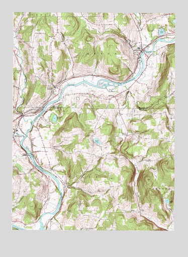
Afton, NY USGS Topographic Map
Click on map above to begin viewing in our Map Viewer.

This topographic map contains these locations and features:
Feature Name Type Latitude Longitude GNIS ID View Map
AftonPopulated PlaceN42.2281°W75.5266°942198View Map
Afton Elementary SchoolSchoolN42.2300°W75.5279°2669137View Map
Afton Fire DepartmentBuildingN42.2284°W75.5271°2734709View Map
Afton Free LibraryBuildingN42.2253°W75.5287°2617204View Map
Afton Golf ClubLocaleN42.2412°W75.5155°2615336View Map
Afton LakeLakeN42.2392°W75.5105°942199View Map
Afton Middle - High SchoolSchoolN42.2302°W75.5289°2668971View Map
Afton Post OfficePost OfficeN42.2243°W75.5289°2617783View Map
Afton Presbyterian ChurchChurchN42.2294°W75.5275°2496766View Map
Afton United Methodist ChurchChurchN42.2289°W75.5286°2496765View Map
Beaver PondLakeN42.1419°W75.5054°943429View Map
Belden BrookStreamN42.1781°W75.6160°943569View Map
BettsburgPopulated PlaceN42.2017°W75.5471°972228View Map
Bumps CreekStreamN42.2312°W75.5218°945175View Map
Center VillagePopulated PlaceN42.1676°W75.6132°946204View Map
Cornell CreekStreamN42.2087°W75.5418°947462View Map
DoravillePopulated PlaceN42.1504°W75.5844°948582View Map
Eastside CemeteryCemeteryN42.2260°W75.5180°949309View Map
First Baptist ChurchChurchN42.2306°W75.5256°2496764View Map
First Baptist Church CemeteryCemeteryN42.2301°W75.5250°2496762View Map
Glenwood CemeteryCemeteryN42.2317°W75.5328°951238View Map
Harpur CemeteryCemeteryN42.1367°W75.6017°952250View Map
HarpursvillePopulated PlaceN42.1784°W75.6246°952251View Map
Harpursville Fire Department Station 1BuildingN42.1786°W75.6244°2718659View Map
Harpursville Junior - Senior High SchoolSchoolN42.1819°W75.6219°2597373View Map
Higher Ground Christian ChurchChurchN42.2242°W75.5192°2496767View Map
Hope Congregational ChurchChurchN42.2269°W75.5276°2616496View Map
HowesPopulated PlaceN42.1359°W75.5241°972630View Map
Huggins CemeteryCemeteryN42.1395°W75.5046°953401View Map
Kellystone ParkLocaleN42.1691°W75.5247°2598413View Map
Kelsey CreekStreamN42.2281°W75.5216°969289View Map
NinevehPopulated PlaceN42.1942°W75.6024°958608View Map
Nineveh JunctionPopulated PlaceN42.2070°W75.5932°958609View Map
Nineveh Plains CemeteryCemeteryN42.1822°W75.6052°967324View Map
Nineveh Post OfficePost OfficeN42.1943°W75.6025°2598381View Map
Nineveh Presbyterian CemeteryCemeteryN42.1911°W75.6102°2496769View Map
Nineveh Presbyterian ChurchChurchN42.1926°W75.6047°2597343View Map
Nineveh Public Library of Colesville TownshipBuildingN42.1941°W75.6028°2598433View Map
Perch PondLakeN42.1762°W75.5598°960180View Map
Perch Pond CemeteryCemeteryN42.1673°W75.5567°960182View Map
Pickerel PondLakeN42.1890°W75.5924°960329View Map
Reed CreekStreamN42.2090°W75.5824°962345View Map
Reed Guy CemeteryCemeteryN42.2132°W75.5709°2559181View Map
Riverview CemeteryCemeteryN42.1771°W75.6230°2496770View Map
Saint Agnes Catholic ChurchChurchN42.2289°W75.5269°2496763View Map
Saint Anns Episcopal ChurchChurchN42.2265°W75.5282°963310View Map
Stevens CemeteryCemeteryN42.2164°W75.6182°946680View Map
Taft PondLakeN42.2337°W75.5357°966993View Map
Three Pines Community ChurchChurchN42.1513°W75.5843°2597359View Map
Town of AftonCivilN42.2276°W75.5241°978657View Map
Vallonia SpringsPopulated PlaceN42.1798°W75.5368°973187View Map
Village of AftonCivilN42.2291°W75.5247°2391501View Map
W A Olmsted Elementary SchoolSchoolN42.1807°W75.6213°2597281View Map
Wylie BrookStreamN42.1859°W75.6105°971776View Map

Note: Coordinates in the location and feature list above are referenced to NAD83 datum.


Copyright (C) 2008-2025 Ryan Niemi / Sunset Dynamics ... All Rights Reserved