TopoQuest Logo
Do you find TopoQuest useful?
Help keep TopoQuest running and adding new maps/features by donating!
Bitcoin:  19c7KJd3qBynnjoSw5npx9KScwjBe4ifkT
Litecoin:  LXs6TkuXGGXo1vDsWCkWVdjQX94eUKd6ui
Home View Maps Find Maps Find Places Resources & Links


Detroit, Oregon Topographic Map

USGS Map Title: Detroit, OR
USGS Map MRC: 44122F2
DRG (GeoTIFF) Download: o44122f2.tif


Neighboring USGS Topographic Map Quads:


  Elkhorn, OR  
44122G3
 

  Battle Ax, OR  
44122G2
 

  Mother Lode Mountain, OR  
44122G1
 

  Lawhead Creek, OR  
44122F3
 

  Detroit, OR  
44122F2
 

  Idanha, OR  
44122F1
 

  Quartzville, OR  
44122E3
 

  Chimney Peak, OR  
44122E2
 

  Coffin Mountain, OR  
44122E1


Map MRC Location:

N45°
W123°
N45°
W122°
H8 H7 H6 H5 H4 H3 H2 H1
G8 G7 G6 G5 G4 G3 G2 G1
F8 F7 F6 F5 F4 F3 F2 F1
E8 E7 E6 E5 E4 E3 E2 E1
D8 D7 D6 D5 D4 D3 D2 D1
C8 C7 C6 C5 C4 C3 C2 C1
B8 B7 B6 B5 B4 B3 B2 B1
A8 A7 A6 A5 A4 A3 A2 A1
N44°
W123°
N44°
W122°

Detroit, OR USGS 1:24K Topographic Map Preview:
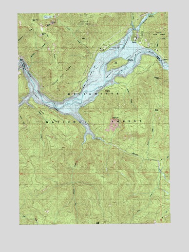
Detroit, OR USGS Topographic Map
Click on map above to begin viewing in our Map Viewer.

This topographic map contains these locations and features:
Feature Name Type Latitude Longitude GNIS ID View Map
Beard CreekStreamN44.6626°W122.1434°1137782View Map
Beard SaddleGapN44.6915°W122.1387°1137783View Map
Berry (historical)LocaleN44.6998°W122.2137°1166757View Map
Berry Post Office (historical)Post OfficeN44.6998°W122.2137°1164911View Map
Blowout CliffCliffN44.6876°W122.1617°1138281View Map
Blowout CreekStreamN44.6907°W122.2037°1138283View Map
Box Canyon CreekStreamN44.6785°W122.1937°1162848View Map
Breitenbush RiverStreamN44.7493°W122.1340°1138594View Map
Canyon CreekStreamN44.7498°W122.1337°1139320View Map
City of DetroitCivilN44.7338°W122.1512°2410330View Map
Cliff CreekStreamN44.6554°W122.1329°1162905View Map
Cove Creek Campground Boat RampLocaleN44.7140°W122.1576°2700072View Map
Cove Creek Recreation SiteLocaleN44.7110°W122.1615°1926265View Map
DetroitPopulated PlaceN44.7340°W122.1498°1140929View Map
Detroit City HallBuildingN44.7357°W122.1514°2699320View Map
Detroit DamDamN44.7210°W122.2498°1140930View Map
Detroit Flats Boat LandingLocaleN44.7273°W122.1523°2699321View Map
Detroit Flats Recreation SiteLocaleN44.7285°W122.1479°1926266View Map
Detroit LakeReservoirN44.7109°W122.1887°1639301View Map
Detroit Lake MarinaHarborN44.7394°W122.1514°2699322View Map
Detroit Lake State ParkParkN44.7271°W122.1792°1140931View Map
Detroit Lake State Park Boat Ramp DLocaleN44.7281°W122.1760°2699323View Map
Detroit Lake State Park Boat Ramp GLocaleN44.7307°W122.1701°2699324View Map
Detroit Lake State Park Fishing DockLocaleN44.7291°W122.1732°2699325View Map
Detroit Lake State Park Moorage Boat Dock FHarborN44.7287°W122.1734°2699326View Map
Detroit Lake State Park Moorage Boat Dock HHarborN44.7316°W122.1667°2699327View Map
Detroit Municipal CourtBuildingN44.7357°W122.1513°2699328View Map
Detroit Post OfficePost OfficeN44.7360°W122.1514°1165153View Map
Elephant RockPillarN44.7442°W122.2235°1141730View Map
Elk River (historical)LocaleN44.7046°W122.2359°1166422View Map
French CreekStreamN44.7440°W122.1551°1142462View Map
Gravel Spur (historical)LocaleN44.7010°W122.2317°1166424View Map
Hall RidgeRidgeN44.7304°W122.2217°1143225View Map
Halls (historical)LocaleN44.7132°W122.2415°1166425View Map
Hammond Lumber Company Number 2 (historical)LocaleN44.7393°W122.1504°1166427View Map
Hansen CreekStreamN44.7212°W122.1292°1143269View Map
Heater CreekStreamN44.6971°W122.2442°1143435View Map
Idanha - Detroit Rural Fire Protection District SubstationBuildingN44.7359°W122.1514°2576512View Map
K CreekStreamN44.6615°W122.1356°1144472View Map
Kanes MarinaHarborN44.7357°W122.1575°2699986View Map
Kinney RidgeRidgeN44.6868°W122.2226°1144633View Map
Larson (historical)LocaleN44.7290°W122.1445°1166430View Map
Lucky ButteSummitN44.6258°W122.1848°1145656View Map
Mackey CreekStreamN44.7268°W122.1373°1145715View Map
Madill CreekStreamN44.7110°W122.2387°1153990View Map
Mongold Boat RampLocaleN44.7122°W122.1928°2699620View Map
Mongold Day Use Area Marina Transient DockHarborN44.7117°W122.1928°2699989View Map
Mongold Recreation SiteLocaleN44.7157°W122.1929°1167113View Map
Piety Island Boat - In Campground Boat LandingLocaleN44.7225°W122.1595°2699917View Map
Piety Island Recreation SiteLocaleN44.7207°W122.1637°1156745View Map
Piety KnobIslandN44.7204°W122.1713°1158419View Map
Redne Post Office (historical)Post OfficeN44.7165°W122.2429°1165841View Map
Sauers CreekStreamN44.7082°W122.1717°1149077View Map
South Shore Campground Boat RampLocaleN44.7077°W122.1737°2699912View Map
Southshore CampgroundLocaleN44.7054°W122.1762°1161734View Map
Sportsman Club Private MarinaHarborN44.7187°W122.1524°2699838View Map
Stahlman CreekStreamN44.7179°W122.1526°1162310View Map
Stahlman PointSummitN44.7104°W122.1342°1150320View Map
Tumble CreekStreamN44.7221°W122.1865°1151499View Map
Tumble LakeLakeN44.7475°W122.2263°1151504View Map
Tumble RockPillarN44.7425°W122.2275°1163309View Map
United States Forest Service Detroit Flats Boat RampLocaleN44.7287°W122.1462°2699908View Map
United States Forest Service Detroit Ranger DistrictBuildingN44.7313°W122.1747°2576703View Map
Upper Arm Recreation SiteLocaleN44.7471°W122.1429°1156746View Map
Volcano TrailTrailN44.6607°W122.2315°1151785View Map
Water Tower MountainSummitN44.7453°W122.2398°1151940View Map
Whitman CreekStreamN44.7179°W122.2429°1152278View Map
Whitman RockPillarN44.7362°W122.2315°1152279View Map

Note: Coordinates in the location and feature list above are referenced to NAD83 datum.


Copyright (C) 2008-2025 Ryan Niemi / Sunset Dynamics ... All Rights Reserved