TopoQuest Logo
Do you find TopoQuest useful?
Help keep TopoQuest running and adding new maps/features by donating!
Bitcoin:  19c7KJd3qBynnjoSw5npx9KScwjBe4ifkT
Litecoin:  LXs6TkuXGGXo1vDsWCkWVdjQX94eUKd6ui
Home View Maps Find Maps Find Places Resources & Links


Dewitt Peak, California Topographic Map

USGS Map Title: Dewitt Peak, CA
USGS Map MRC: 40121B8
DRG (GeoTIFF) Download: o40121b8.tif


Neighboring USGS Topographic Map Quads:


  Dales, CA  
40122C1
 

  Inskip Hill, CA  
40121C8
 

  Finley Butte, CA  
40121C7
 

  Tuscan Springs, CA  
40122B1
 

  Dewitt Peak, CA  
40121B8
 

  Panther Spring, CA  
40121B7
 

  Los Molinos, CA  
40122A1
 

  Acorn Hollow, CA  
40121A8
 

  Deer Creek Flat, CA  
40121A7


Map MRC Location:

N41°
W122°
N41°
W121°
H8 H7 H6 H5 H4 H3 H2 H1
G8 G7 G6 G5 G4 G3 G2 G1
F8 F7 F6 F5 F4 F3 F2 F1
E8 E7 E6 E5 E4 E3 E2 E1
D8 D7 D6 D5 D4 D3 D2 D1
C8 C7 C6 C5 C4 C3 C2 C1
B8 B7 B6 B5 B4 B3 B2 B1
A8 A7 A6 A5 A4 A3 A2 A1
N40°
W122°
N40°
W121°

Dewitt Peak, CA USGS 1:24K Topographic Map Preview:
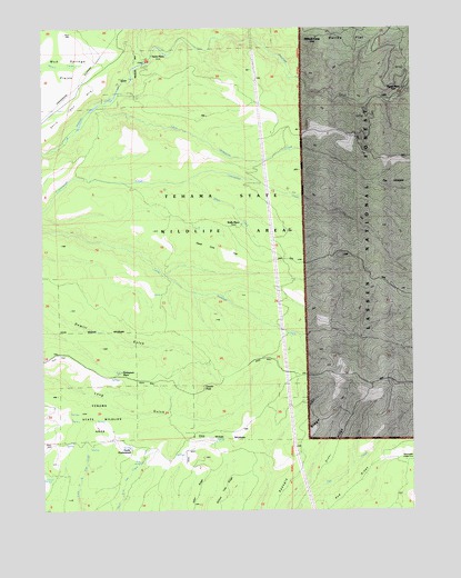
Dewitt Peak, CA USGS Topographic Map
Click on map above to begin viewing in our Map Viewer.

This topographic map contains these locations and features:
Feature Name Type Latitude Longitude GNIS ID View Map
Arts PondReservoirN40.1374°W121.9682°1666413View Map
Cameron CreekStreamN40.2463°W121.9417°220432View Map
Cameron Place (historical)LocaleN40.1960°W121.9314°1682333View Map
Dead Cow FlatFlatN40.1924°W121.9411°1666415View Map
Devils Half AcreAreaN40.2293°W121.9903°1666416View Map
Dewitt PeakSummitN40.1571°W121.9464°222338View Map
Durley FlatFlatN40.2477°W121.8950°222750View Map
Facht HomesteadLocaleN40.1407°W121.9705°223314View Map
Facht PlacePopulated PlaceN40.2424°W121.9633°1656004View Map
Glassburger Place (historical)LocaleN40.2402°W121.8783°1682337View Map
Greer RidgeRidgeN40.1413°W121.9019°1666417View Map
Indian CreekStreamN40.2324°W121.8775°261734View Map
Little Grapevine CreekStreamN40.2221°W121.9803°262607View Map
P-38 CrossingCrossingN40.1693°W121.8969°1656204View Map
Payne PlacePopulated PlaceN40.2332°W121.8775°1656211View Map
Rasmussen Cabin (historical)BuildingN40.1379°W121.8786°1666421View Map
Shaw CreekStreamN40.2096°W121.9511°232883View Map
Speegle RidgeRidgeN40.1379°W121.9125°1666425View Map
Tehama State Wildlife AreaParkN40.2096°W121.9261°1692761View Map
The VineyardAreaN40.2088°W121.8830°236228View Map
Thompson PlacePopulated PlaceN40.1602°W121.9739°1656364View Map
Wells PlacePopulated PlaceN40.1979°W121.9322°1656403View Map
Willards CampLocaleN40.2471°W121.9086°237836View Map

Note: Coordinates in the location and feature list above are referenced to NAD83 datum.


Copyright (C) 2008-2025 Ryan Niemi / Sunset Dynamics ... All Rights Reserved