TopoQuest Logo
Do you find TopoQuest useful?
Help keep TopoQuest running and adding new maps/features by donating!
Bitcoin:  19c7KJd3qBynnjoSw5npx9KScwjBe4ifkT
Litecoin:  LXs6TkuXGGXo1vDsWCkWVdjQX94eUKd6ui
Home View Maps Find Maps Find Places Resources & Links


Inskip Hill, California Topographic Map

USGS Map Title: Inskip Hill, CA
USGS Map MRC: 40121C8
DRG (GeoTIFF) Download: o40121c8.tif


Neighboring USGS Topographic Map Quads:


  Tuscan Buttes NE, CA  
40122D1
 

  Shingletown, CA  
40121D8
 

  Manton, CA  
40121D7
 

  Dales, CA  
40122C1
 

  Inskip Hill, CA  
40121C8
 

  Finley Butte, CA  
40121C7
 

  Tuscan Springs, CA  
40122B1
 

  Dewitt Peak, CA  
40121B8
 

  Panther Spring, CA  
40121B7


Map MRC Location:

N41°
W122°
N41°
W121°
H8 H7 H6 H5 H4 H3 H2 H1
G8 G7 G6 G5 G4 G3 G2 G1
F8 F7 F6 F5 F4 F3 F2 F1
E8 E7 E6 E5 E4 E3 E2 E1
D8 D7 D6 D5 D4 D3 D2 D1
C8 C7 C6 C5 C4 C3 C2 C1
B8 B7 B6 B5 B4 B3 B2 B1
A8 A7 A6 A5 A4 A3 A2 A1
N40°
W122°
N40°
W121°

Inskip Hill, CA USGS 1:24K Topographic Map Preview:
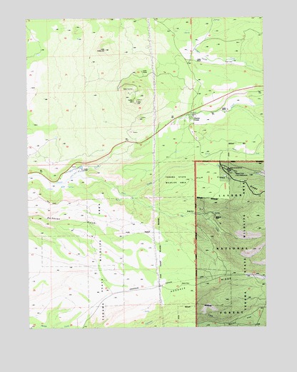
Inskip Hill, CA USGS Topographic Map
Click on map above to begin viewing in our Map Viewer.

This topographic map contains these locations and features:
Feature Name Type Latitude Longitude GNIS ID View Map
Childs RanchLocaleN40.3579°W121.9111°220990View Map
Hogback RidgeRidgeN40.2679°W121.8830°266812View Map
Inskip HillSummitN40.3418°W121.9439°225946View Map
Lane ValleyValleyN40.3643°W121.9119°262314View Map
Lane Valley School (historical)SchoolN40.3532°W121.8819°1682338View Map
Little Inskip HillSummitN40.3629°W121.9583°227281View Map
McKenzie PlacePopulated PlaceN40.2946°W121.9019°1659089View Map
Meyers PlacePopulated PlaceN40.2668°W121.9205°1659120View Map
Mount Lassen Trout FarmLocaleN40.3152°W121.9722°229153View Map
North Fork Plum CreekStreamN40.3160°W121.9050°264198View Map
Oat CreekStreamN40.3038°W121.9455°264274View Map
Paynes CreekPopulated PlaceN40.3354°W121.9150°230427View Map
Paynes Creek Census Designated PlaceCensusN40.3409°W121.9174°2628773View Map
Plum CreekStreamN40.3104°W121.9783°264859View Map
Plum Creek RidgeRidgeN40.3043°W121.8919°267134View Map
Plum Valley Elementary SchoolSchoolN40.3322°W121.9125°1692757View Map
Shults RanchLocaleN40.3379°W121.8944°233072View Map
Tehama County Fire Department Paynes CreekBuildingN40.3320°W121.9256°2622014View Map
Tehama County Fire Department Station 21 Paynes CreekBuildingN40.3314°W121.9135°2622097View Map
Wade PlacePopulated PlaceN40.2960°W121.9153°1660113View Map

Note: Coordinates in the location and feature list above are referenced to NAD83 datum.


Copyright (C) 2008-2025 Ryan Niemi / Sunset Dynamics ... All Rights Reserved