TopoQuest Logo
Do you find TopoQuest useful?
Help keep TopoQuest running and adding new maps/features by donating!
Bitcoin:  19c7KJd3qBynnjoSw5npx9KScwjBe4ifkT
Litecoin:  LXs6TkuXGGXo1vDsWCkWVdjQX94eUKd6ui
Home View Maps Find Maps Find Places Resources & Links


Distant, Pennsylvania Topographic Map

USGS Map Title: Distant, PA
USGS Map MRC: 40079H3
DRG (GeoTIFF) Download: o40079h3.tif


Neighboring USGS Topographic Map Quads:


  Sligo, PA  
41079A4
 

  New Bethlehem, PA  
41079A3
 

  Summerville, PA  
41079A2
 

  Templeton, PA  
40079H4
 

  Distant, PA  
40079H3
 

  Dayton, PA  
40079H2
 

  Mosgrove, PA  
40079G4
 

  Rural Valley, PA  
40079G3
 

  Plumville, PA  
40079G2


Map MRC Location:

N41°
W80°
N41°
W79°
H8 H7 H6 H5 H4 H3 H2 H1
G8 G7 G6 G5 G4 G3 G2 G1
F8 F7 F6 F5 F4 F3 F2 F1
E8 E7 E6 E5 E4 E3 E2 E1
D8 D7 D6 D5 D4 D3 D2 D1
C8 C7 C6 C5 C4 C3 C2 C1
B8 B7 B6 B5 B4 B3 B2 B1
A8 A7 A6 A5 A4 A3 A2 A1
N40°
W80°
N40°
W79°

Distant, PA USGS 1:24K Topographic Map Preview:
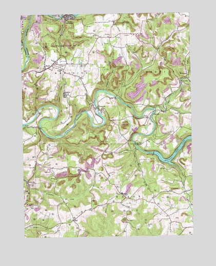
Distant, PA USGS Topographic Map
Click on map above to begin viewing in our Map Viewer.

This topographic map contains these locations and features:
Feature Name Type Latitude Longitude GNIS ID View Map
BelknapPopulated PlaceN40.8992°W79.3028°1169142View Map
Belknap CemeteryCemeteryN40.8926°W79.2957°2775870View Map
Borough of South BethlehemCivilN40.9992°W79.3395°1214858View Map
Camp RunStreamN40.9248°W79.2898°1171078View Map
Cathcart RunStreamN40.9570°W79.3125°1171338View Map
Cave RunStreamN40.9387°W79.3720°1202242View Map
CharlestownPopulated PlaceN40.9606°W79.2562°1171583View Map
Colwell CemeteryCemeteryN40.9401°W79.3631°2775892View Map
Colwell StationLocaleN40.9367°W79.3739°1212183View Map
Concord ChurchChurchN40.8906°W79.3239°1172285View Map
Concord HillLocaleN40.8909°W79.3248°1206966View Map
Concord Presbyterian Church CemeteryCemeteryN40.8911°W79.3243°2775893View Map
DistantPopulated PlaceN40.9695°W79.3567°1173301View Map
Distant Area Volunteer Fire Company Station 300BuildingN40.9685°W79.3603°2645525View Map
Distant Post OfficePost OfficeN40.9745°W79.3494°2779898View Map
EddyvillePopulated PlaceN40.9428°W79.2775°1173986View Map
Glade RunStreamN40.9148°W79.2631°1175661View Map
GoheenvillePopulated PlaceN40.9067°W79.3720°1175777View Map
Hamilton RunStreamN40.9501°W79.3212°1202241View Map
Jerusalem CemeteryCemeteryN40.9198°W79.3564°1178062View Map
Jerusalem ChurchChurchN40.9078°W79.3509°1178066View Map
Junction Bostonia Branch StationLocaleN40.9992°W79.3470°1212167View Map
Little Mudlick CreekStreamN40.9528°W79.3025°1179618View Map
Mahoning Creek DamDamN40.9217°W79.2773°1180223View Map
Mahoning Creek Lake Recreation AreaParkN40.9237°W79.2692°1212182View Map
Mahoning FurnacePopulated PlaceN40.9459°W79.3642°1200799View Map
Mahoning SchoolSchoolN40.9717°W79.3298°1180227View Map
McCrea FurnacePopulated PlaceN40.9262°W79.2909°1204130View Map
McCreas Furnace CemeteryCemeteryN40.9244°W79.2954°2775931View Map
McWilliamsPopulated PlaceN40.9659°W79.2520°1204141View Map
Milliron Family CemeteryCemeteryN40.9268°W79.2998°2775934View Map
Mount Zion CemeteryCemeteryN40.9954°W79.3064°2775941View Map
Mudlic CemeteryCemeteryN40.9799°W79.2752°2775943View Map
Mudlick CreekStreamN40.9626°W79.2525°1182061View Map
MuffPopulated PlaceN40.8845°W79.3381°1204242View Map
Oakland CemeteryCemeteryN40.9712°W79.3459°1182831View Map
Oakland ChurchChurchN40.9687°W79.3450°1182832View Map
Oakland StationLocaleN40.9376°W79.3398°1212184View Map
Pine RunStreamN40.9465°W79.2775°1183896View Map
PutneyvillePopulated PlaceN40.9467°W79.3175°1184507View Map
Putneyville CemeteryCemeteryN40.9426°W79.3132°2775953View Map
Rehobeth Reformed Presbyterian Church CemeteryCemeteryN40.8924°W79.3692°2775947View Map
Saint Marks ChurchChurchN40.9415°W79.2806°1186334View Map
Saint Marks Lutheran Church CemeteryCemeteryN40.9420°W79.2804°2775904View Map
SeminolePopulated PlaceN40.9548°W79.3428°1187249View Map
Smullin CemeteryCemeteryN40.9625°W79.3347°2775980View Map
South BethlehemPopulated PlaceN40.9995°W79.3409°1193395View Map
State Game Lands Number 137ParkN40.9851°W79.3428°1188446View Map
Township of MahoningCivilN40.9612°W79.3417°1215850View Map
Township of RedbankCivilN40.9783°W79.2508°1215858View Map
Township of WayneCivilN40.8822°W79.2921°1215864View Map

Note: Coordinates in the location and feature list above are referenced to NAD83 datum.


Copyright (C) 2008-2025 Ryan Niemi / Sunset Dynamics ... All Rights Reserved