TopoQuest Logo
Do you find TopoQuest useful?
Help keep TopoQuest running and adding new maps/features by donating!
Bitcoin:  19c7KJd3qBynnjoSw5npx9KScwjBe4ifkT
Litecoin:  LXs6TkuXGGXo1vDsWCkWVdjQX94eUKd6ui
Home View Maps Find Maps Find Places Resources & Links


Summerville, Pennsylvania Topographic Map

USGS Map Title: Summerville, PA
USGS Map MRC: 41079A2
DRG (GeoTIFF) Download: o41079a2.tif


Neighboring USGS Topographic Map Quads:


  Strattanville, PA  
41079B3
 

  Corsica, PA  
41079B2
 

  Brookville, PA  
41079B1
 

  New Bethlehem, PA  
41079A3
 

  Summerville, PA  
41079A2
 

  Coolspring, PA  
41079A1
 

  Distant, PA  
40079H3
 

  Dayton, PA  
40079H2
 

  Valier, PA  
40079H1


Map MRC Location:

N42°
W80°
N42°
W79°
H8 H7 H6 H5 H4 H3 H2 H1
G8 G7 G6 G5 G4 G3 G2 G1
F8 F7 F6 F5 F4 F3 F2 F1
E8 E7 E6 E5 E4 E3 E2 E1
D8 D7 D6 D5 D4 D3 D2 D1
C8 C7 C6 C5 C4 C3 C2 C1
B8 B7 B6 B5 B4 B3 B2 B1
A8 A7 A6 A5 A4 A3 A2 A1
N41°
W80°
N41°
W79°

Summerville, PA USGS 1:24K Topographic Map Preview:
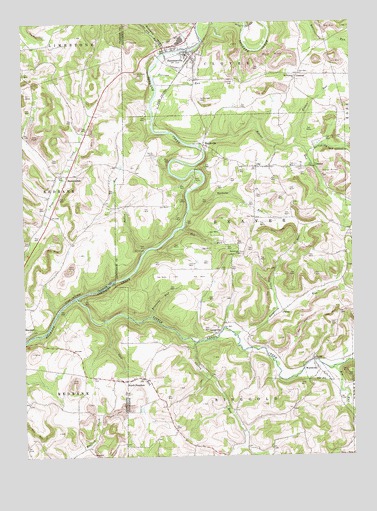
Summerville, PA USGS Topographic Map
Click on map above to begin viewing in our Map Viewer.

This topographic map contains these locations and features:
Feature Name Type Latitude Longitude GNIS ID View Map
Beaver RunStreamN41.0892°W79.1825°1169039View Map
Bethlehem ChurchChurchN41.0584°W79.1675°1169434View Map
Big RunStreamN41.0251°W79.1323°1169578View Map
Borough of SummervilleCivilN41.1163°W79.1881°1215303View Map
Borough of WorthvilleCivilN41.0250°W79.1405°1215308View Map
Brocious RunStreamN41.0403°W79.2017°1170303View Map
Carrier CemeteryCemeteryN41.1086°W79.1691°1171259View Map
Carrier RunStreamN41.1090°W79.1995°1171260View Map
Cherry RunStreamN41.0328°W79.1848°1171668View Map
Cliff School (historical)SchoolN41.0484°W79.1281°1201187View Map
Coleman SchoolSchoolN41.0242°W79.2273°1201045View Map
ConiferPopulated PlaceN41.0831°W79.1386°1203324View Map
Conifer CemeteryCemeteryN41.0827°W79.1427°1172331View Map
ContentPopulated PlaceN41.1101°W79.1445°1203329View Map
Dinger SchoolSchoolN41.0653°W79.2273°1201111View Map
Doverspike Number One DamDamN41.0001°W79.1798°1195192View Map
Eckler RunStreamN41.0895°W79.1459°1173972View Map
Ferguson RunStreamN41.0351°W79.1700°1174689View Map
FreedomLocaleN41.0220°W79.2131°1202114View Map
HeathvillePopulated PlaceN41.0898°W79.1806°1203768View Map
Himes School (historical)SchoolN41.0909°W79.2289°1201046View Map
Kemmer's GreenhouseBuildingN41.0731°W79.2403°2650572View Map
LangvillePopulated PlaceN41.0356°W79.1764°1203983View Map
Little Sandy CreekStreamN41.0456°W79.2300°1200096View Map
Miller RunStreamN41.0412°W79.2373°1201961View Map
Mottern SchoolSchoolN41.0145°W79.1414°1201043View Map
Mount Pleasant ChurchChurchN41.1092°W79.1456°1181823View Map
Mount Pleasant SchoolSchoolN41.1101°W79.1450°1201040View Map
Nolf RunStreamN41.0392°W79.2184°1182499View Map
North FreedomPopulated PlaceN41.0220°W79.2098°1182592View Map
OhlPopulated PlaceN41.0834°W79.1609°1182885View Map
PansyPopulated PlaceN41.0417°W79.1514°1204354View Map
Patton RunStreamN41.0590°W79.2036°1183385View Map
Red RunStreamN41.0653°W79.1898°1184784View Map
Reitz RunStreamN41.0426°W79.1542°1184890View Map
Runaway RunStreamN41.1162°W79.1956°1185618View Map
Shaffer's GreenhouseBuildingN41.0478°W79.1378°2650574View Map
ShannondalePopulated PlaceN41.0812°W79.2323°1204626View Map
Smith CemeteryCemeteryN41.0870°W79.1997°1187858View Map
SummervillePopulated PlaceN41.1162°W79.1867°1189030View Map
Summerville Post OfficePost OfficeN41.1157°W79.1852°2779652View Map
Summerville Volunteer Fire Department Station 7BuildingN41.1205°W79.1867°2645621View Map
Tarkiln RunStreamN41.0703°W79.1867°1199665View Map
Thomas School (historical)SchoolN41.0684°W79.1586°1201041View Map
Township of BeaverCivilN41.0646°W79.1663°1216556View Map
Trinity Reformed CemeteryCemeteryN41.0224°W79.2149°2775955View Map
TroyPopulated PlaceN41.1176°W79.1931°1201954View Map
Vandervort CemeteryCemeteryN41.1028°W79.1827°1190357View Map
Weaver SchoolSchoolN41.0131°W79.1709°1201044View Map
Welch RunStreamN41.1248°W79.1814°1209367View Map
Westview CemeteryCemeteryN41.1096°W79.2056°1191183View Map
WorthvillePopulated PlaceN41.0245°W79.1381°1191796View Map
Zion CemeteryCemeteryN41.0539°W79.1750°1191964View Map
Zion School (historical)SchoolN41.0481°W79.1789°1201042View Map

Note: Coordinates in the location and feature list above are referenced to NAD83 datum.


Copyright (C) 2008-2024 Ryan Niemi / Sunset Dynamics ... All Rights Reserved