TopoQuest Logo
Do you find TopoQuest useful?
Help keep TopoQuest running and adding new maps/features by donating!
Bitcoin:  19c7KJd3qBynnjoSw5npx9KScwjBe4ifkT
Litecoin:  LXs6TkuXGGXo1vDsWCkWVdjQX94eUKd6ui
Home View Maps Find Maps Find Places Resources & Links


Mitchell, Georgia Topographic Map

USGS Map Title: Mitchell, GA
USGS Map MRC: 33082B6
DRG (GeoTIFF) Download: o33082b6.tif


Neighboring USGS Topographic Map Quads:


  Jewell, GA  
33082C7
 

  Beall Springs, GA  
33082C6
 

  Bastonville, GA  
33082C5
 

  Warthen NE, GA  
33082B7
 

  Mitchell, GA  
33082B6
 

  Gibson, GA  
33082B5
 

  Warthen, GA  
33082A7
 

  Downs, GA  
33082A6
 

  Grange, GA  
33082A5


Map MRC Location:

N34°
W83°
N34°
W82°
H8 H7 H6 H5 H4 H3 H2 H1
G8 G7 G6 G5 G4 G3 G2 G1
F8 F7 F6 F5 F4 F3 F2 F1
E8 E7 E6 E5 E4 E3 E2 E1
D8 D7 D6 D5 D4 D3 D2 D1
C8 C7 C6 C5 C4 C3 C2 C1
B8 B7 B6 B5 B4 B3 B2 B1
A8 A7 A6 A5 A4 A3 A2 A1
N33°
W83°
N33°
W82°

Mitchell, GA USGS 1:24K Topographic Map Preview:
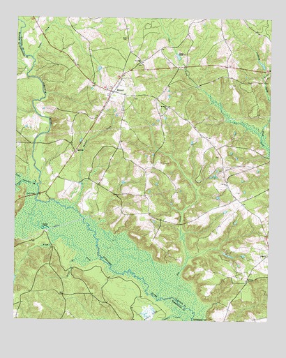
Mitchell, GA USGS Topographic Map
Click on map above to begin viewing in our Map Viewer.

This topographic map contains these locations and features:
Feature Name Type Latitude Longitude GNIS ID View Map
AgricolaPopulated PlaceN33.1946°W82.7204°326152View Map
Allen CemeteryCemeteryN33.1929°W82.6499°345624View Map
Allen-Snider CemeteryCemeteryN33.1782°W82.6410°345625View Map
Big CreekStreamN33.1293°W82.6612°311359View Map
Braddy - Hilson CemeteryCemeteryN33.1685°W82.6951°345629View Map
Chalker (historical)Populated PlaceN33.1615°W82.7349°348298View Map
Chalker LakeReservoirN33.1630°W82.7347°312541View Map
Cobb BridgesBridgeN33.1768°W82.7385°355205View Map
Cooper CemeteryCemeteryN33.1793°W82.6260°345631View Map
Cowpen CreekStreamN33.1818°W82.7457°355359View Map
Euphrates CemeteryCemeteryN33.1415°W82.6360°345635View Map
Euphrates ChurchChurchN33.1418°W82.6351°355722View Map
Floyd CreekStreamN33.1499°W82.7068°355857View Map
Fords CreekStreamN33.2326°W82.7415°314259View Map
Friendship CemeteryCemeteryN33.2313°W82.6893°345637View Map
Friendship ChurchChurchN33.2313°W82.6885°355942View Map
Full Gospel Holiness ChurchChurchN33.2299°W82.6874°345638View Map
Griffen CemeteryCemeteryN33.2307°W82.6457°345647View Map
Griffin ChapelChurchN33.1918°W82.6965°345648View Map
Griffin Chapel CemeteryCemeteryN33.1918°W82.6968°345649View Map
Harris BranchStreamN33.2268°W82.6282°315178View Map
Harrisons BridgeBridgeN33.1976°W82.7410°348330View Map
Howard CemeteryCemeteryN33.2040°W82.6429°345652View Map
Jumping Gully CreekStreamN33.2001°W82.6290°316306View Map
Kents MillpondReservoirN33.2342°W82.6704°316392View Map
Kents Millpond DamDamN33.2338°W82.6699°339481View Map
Kitchens - Wilcher CemeteryCemeteryN33.2226°W82.7112°345655View Map
Little Ogeechee RiverStreamN33.1807°W82.7390°317135View Map
Llewellyn - Kitchens CemeteryCemeteryN33.2204°W82.7021°345657View Map
MitchellPopulated PlaceN33.2199°W82.7032°318336View Map
Mitchell Baptist ChurchChurchN33.2171°W82.7040°345662View Map
Mitchell CemeteryCemeteryN33.2171°W82.7037°345663View Map
Mitchell CemeteryCemeteryN33.2199°W82.7057°345664View Map
Mitchell DivisionCivilN33.1878°W82.6701°1936412View Map
Mitchell Methodist ChurchChurchN33.2201°W82.7062°345665View Map
Mitchell Volunteer Fire DepartmentBuildingN33.2200°W82.7026°2604811View Map
Mott BranchStreamN33.2268°W82.7449°348362View Map
Mount Nebo CemeteryCemeteryN33.2135°W82.6760°345666View Map
Mount Nebo ChurchChurchN33.2132°W82.6757°318713View Map
Mount Zion CemeteryCemeteryN33.1810°W82.6457°345667View Map
Mount Zion ChurchChurchN33.1818°W82.6457°318999View Map
Parker BranchStreamN33.1493°W82.7146°320209View Map
Philcher CreekStreamN33.1701°W82.7185°320445View Map
Roberts DamDamN33.1718°W82.6465°338744View Map
Roberts LakeReservoirN33.1706°W82.6463°338745View Map
Saint Paul African Methodist Episcopal ChurchChurchN33.2215°W82.7112°345673View Map
Saint Paul CemeteryCemeteryN33.2215°W82.7115°345674View Map
Sandy Grove Baptist ChurchChurchN33.2171°W82.6921°345675View Map
Sandy Grove CemeteryCemeteryN33.2168°W82.6918°345676View Map
Stephens CreekStreamN33.1265°W82.6621°323574View Map
Town of MitchellCivilN33.2199°W82.7031°2406172View Map
Towner CemeteryCemeteryN33.2318°W82.6743°345682View Map
Union CemeteryCemeteryN33.2007°W82.6551°345683View Map
Walden LakeReservoirN33.2311°W82.6291°339480View Map
Walden Lake DamDamN33.2285°W82.6282°339479View Map
Yarough BranchStreamN33.2110°W82.7401°348436View Map

Note: Coordinates in the location and feature list above are referenced to NAD83 datum.


Copyright (C) 2008-2025 Ryan Niemi / Sunset Dynamics ... All Rights Reserved