TopoQuest Logo
Do you find TopoQuest useful?
Help keep TopoQuest running and adding new maps/features by donating!
Bitcoin:  19c7KJd3qBynnjoSw5npx9KScwjBe4ifkT
Litecoin:  LXs6TkuXGGXo1vDsWCkWVdjQX94eUKd6ui
Home View Maps Find Maps Find Places Resources & Links


Drew, Mississippi Topographic Map

USGS Map Title: Drew, MS
USGS Map MRC: 33090G5
DRG (GeoTIFF) Download: o33090g5.tif


Neighboring USGS Topographic Map Quads:


  Mound Bayou, MS  
33090H6
 

  Baltzer, MS  
33090H5
 

  Rome, MS  
33090H4
 

  Merigold, MS  
33090G6
 

  Drew, MS  
33090G5
 

  Brooks, MS  
33090G4
 

  Cleveland, MS  
33090F6
 

  Ruleville, MS  
33090F5
 

  Rattlesnake Bayou, MS  
33090F4


Map MRC Location:

N34°
W91°
N34°
W90°
H8 H7 H6 H5 H4 H3 H2 H1
G8 G7 G6 G5 G4 G3 G2 G1
F8 F7 F6 F5 F4 F3 F2 F1
E8 E7 E6 E5 E4 E3 E2 E1
D8 D7 D6 D5 D4 D3 D2 D1
C8 C7 C6 C5 C4 C3 C2 C1
B8 B7 B6 B5 B4 B3 B2 B1
A8 A7 A6 A5 A4 A3 A2 A1
N33°
W91°
N33°
W90°

Drew, MS USGS 1:24K Topographic Map Preview:
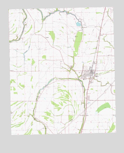
Drew, MS USGS Topographic Map
Click on map above to begin viewing in our Map Viewer.

This topographic map contains these locations and features:
Feature Name Type Latitude Longitude GNIS ID View Map
A W James Elementary SchoolSchoolN33.8040°W90.5373°711595View Map
BallastonPopulated PlaceN33.7862°W90.5334°686467View Map
Bethel ChurchChurchN33.7901°W90.5887°666943View Map
Blackhaw School (historical)SchoolN33.7673°W90.5654°686473View Map
Blue LakeLakeN33.7998°W90.5393°667307View Map
Centerfield ChurchChurchN33.7673°W90.5037°668259View Map
Christian Union ChurchChurchN33.8268°W90.5079°668435View Map
Church of ChristChurchN33.8190°W90.5229°686488View Map
City of DrewCivilN33.8101°W90.5304°2403508View Map
DrewPopulated PlaceN33.8096°W90.5265°669383View Map
Drew CemeteryCemeteryN33.8196°W90.5243°669384View Map
Drew Health ClinicHospitalN33.8123°W90.5281°686497View Map
Drew High SchoolSchoolN33.8090°W90.5362°686498View Map
Drew Lagoon DamDamN33.7918°W90.5334°682342View Map
Drew Police DepartmentBuildingN33.8102°W90.5290°2754093View Map
Drew Post OfficePost OfficeN33.8123°W90.5295°2768724View Map
Drew Public LibraryBuildingN33.8123°W90.5343°686499View Map
Drew United Methodist ChurchChurchN33.8087°W90.5301°686500View Map
Drew Volunteer Fire DepartmentBuildingN33.8052°W90.5371°2665667View Map
DwigginsPopulated PlaceN33.8457°W90.5815°669532View Map
First Baptist ChurchChurchN33.8098°W90.5301°686504View Map
Galen (historical)Populated PlaceN33.7834°W90.5348°707737View Map
Gold Dust Church (historical)ChurchN33.8737°W90.5093°686511View Map
Holly Grove Baptist ChurchChurchN33.8098°W90.5265°686520View Map
Howard Grittman Pond DamDamN33.8618°W90.5551°682373View Map
Hunter High SchoolSchoolN33.8065°W90.5226°671591View Map
JaquithPopulated PlaceN33.7682°W90.5359°691965View Map
Long LakeLakeN33.8701°W90.5718°672845View Map
Long Lake School (historical)SchoolN33.8737°W90.5757°686541View Map
Looney Plantation (historical)LocaleN33.7876°W90.5320°707751View Map
Lusinger LakeLakeN33.8323°W90.6045°672962View Map
Lutken BayouStreamN33.8057°W90.5431°672966View Map
Marshall CemeteryCemeteryN33.7632°W90.5901°673163View Map
Marshall School (historical)SchoolN33.7651°W90.5951°686546View Map
Missionary ChurchChurchN33.7871°W90.5918°673694View Map
Mount Moriah ChurchChurchN33.8554°W90.5359°674074View Map
New Hope ChurchChurchN33.7971°W90.5831°674723View Map
New Hope School (historical)SchoolN33.7959°W90.5681°686562View Map
Nora Smith ChurchChurchN33.8487°W90.5865°686569View Map
Pilgrim Green Church (historical)ChurchN33.8262°W90.5154°686578View Map
Pilgrim Rest ChurchChurchN33.7679°W90.5387°675758View Map
Pleasant Grove ChurchChurchN33.7559°W90.5829°676028View Map
Powell BayouPopulated PlaceN33.8015°W90.5237°686580View Map
Prewitt School (historical)SchoolN33.7904°W90.5887°707762View Map
Promised Land (historical)Populated PlaceN33.8446°W90.5251°707763View Map
Ruleville-Drew AirportAirportN33.7799°W90.5240°680404View Map
Saint Marys Church (historical)ChurchN33.8571°W90.6140°686600View Map
Sandy BayouPopulated PlaceN33.8543°W90.5818°707770View Map
Sandy Bayou CemeteryCemeteryN33.8523°W90.5809°677374View Map
Stansel Plantation (historical)LocaleN33.7687°W90.5348°707735View Map
Strangers Home Church (historical)ChurchN33.7932°W90.5059°686611View Map
Sunflower ChurchChurchN33.8140°W90.6248°678416View Map
Sunflower Plantation (historical)LocaleN33.8140°W90.6168°707777View Map
Supervisor District 5CivilN33.8520°W90.5550°712084View Map
Turner ChapelChurchN33.7651°W90.5956°678973View Map
Wallace ChurchChurchN33.8221°W90.5645°679287View Map
West Drew ChurchChurchN33.8157°W90.5520°679482View Map
WhitneyPopulated PlaceN33.8479°W90.5162°679650View Map
Whitney Church (historical)ChurchN33.8496°W90.5173°686624View Map
WKZB-FM (Drew)TowerN33.7901°W90.5745°680251View Map

Note: Coordinates in the location and feature list above are referenced to NAD83 datum.


Copyright (C) 2008-2024 Ryan Niemi / Sunset Dynamics ... All Rights Reserved