TopoQuest Logo
Do you find TopoQuest useful?
Help keep TopoQuest running and adding new maps/features by donating!
Bitcoin:  19c7KJd3qBynnjoSw5npx9KScwjBe4ifkT
Litecoin:  LXs6TkuXGGXo1vDsWCkWVdjQX94eUKd6ui
Home View Maps Find Maps Find Places Resources & Links


Mound Bayou, Mississippi Topographic Map

USGS Map Title: Mound Bayou, MS
USGS Map MRC: 33090H6
DRG (GeoTIFF) Download: o33090h6.tif


Neighboring USGS Topographic Map Quads:


  Round Lake, MS  
34090A7
 

  Duncan, MS  
34090A6
 

  Mattson, MS  
34090A5
 

  Shelby, MS  
33090H7
 

  Mound Bayou, MS  
33090H6
 

  Baltzer, MS  
33090H5
 

  Pace, MS  
33090G7
 

  Merigold, MS  
33090G6
 

  Drew, MS  
33090G5


Map MRC Location:

N34°
W91°
N34°
W90°
H8 H7 H6 H5 H4 H3 H2 H1
G8 G7 G6 G5 G4 G3 G2 G1
F8 F7 F6 F5 F4 F3 F2 F1
E8 E7 E6 E5 E4 E3 E2 E1
D8 D7 D6 D5 D4 D3 D2 D1
C8 C7 C6 C5 C4 C3 C2 C1
B8 B7 B6 B5 B4 B3 B2 B1
A8 A7 A6 A5 A4 A3 A2 A1
N33°
W91°
N33°
W90°

Mound Bayou, MS USGS 1:24K Topographic Map Preview:
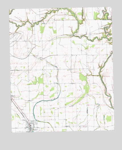
Mound Bayou, MS USGS Topographic Map
Click on map above to begin viewing in our Map Viewer.

This topographic map contains these locations and features:
Feature Name Type Latitude Longitude GNIS ID View Map
Barrows Lake (historical)LakeN33.9184°W90.7190°687956View Map
Beautiful Star ChurchChurchN33.9009°W90.6757°666686View Map
Bethlehem Church (historical)ChurchN33.9626°W90.6537°686470View Map
Bradford ChapelChurchN33.9237°W90.6943°667505View Map
Charles Heinz Catfish Ponds DamDamN33.9701°W90.6984°682422View Map
City of Mound BayouCivilN33.8808°W90.7280°2404316View Map
Dennis Chapel (historical)ChurchN33.8787°W90.6465°686493View Map
Ebenezer Church (historical)ChurchN33.9723°W90.6795°687977View Map
Friendship Church (historical)ChurchN33.9159°W90.6529°686508View Map
German Lane CemeteryCemeteryN33.9521°W90.6765°670363View Map
Germania School (historical)SchoolN33.9523°W90.6759°687982View Map
Goose Lake (historical)LakeN33.9237°W90.6520°686512View Map
Hushpuckena RiverStreamN33.9690°W90.6329°671641View Map
John F Kennedy Memorial High SchoolSchoolN33.8815°W90.7268°710129View Map
Magnolia ChurchChurchN33.9848°W90.7109°673077View Map
Montgomery Elementary SchoolSchoolN33.8793°W90.7259°710135View Map
Morning Star ChurchChurchN33.9521°W90.7209°673842View Map
Mound BayouPopulated PlaceN33.8782°W90.7273°673895View Map
Mound Bayou Post OfficePost OfficeN33.8779°W90.7278°2768780View Map
Mound Bayou Sewage Lagoon DamDamN33.8768°W90.7218°682382View Map
Mound Bayou Volunteer Fire Department Station 9BuildingN33.8786°W90.7300°2666045View Map
Mount Zion Church (historical)ChurchN33.9626°W90.7198°688006View Map
New Hope CemeteryCemeteryN33.9368°W90.6762°674666View Map
New Hope Church (historical)ChurchN33.9379°W90.6754°688009View Map
New Hope School (historical)SchoolN33.9379°W90.6751°688010View Map
New Kingdom Church (historical)ChurchN33.9012°W90.6390°686564View Map
Pecan BayouStreamN33.9837°W90.6670°675561View Map
Pilgrims Rest ChurchChurchN33.9065°W90.7282°675778View Map
Pleasant Grove ChurchChurchN33.9379°W90.7415°676035View Map
Saint Peters Church (historical)ChurchN33.9479°W90.6320°686602View Map
Shiloh Church (historical)ChurchN33.8982°W90.6926°688094View Map
Spring Hill ChurchChurchN33.9232°W90.6762°678133View Map
Supervisor District 3CivilN33.9541°W90.7435°711785View Map
Wander Home ChurchChurchN33.8798°W90.6837°679324View Map
Winstonville Post OfficePost OfficeN33.9108°W90.7500°2768776View Map
Zion CemeteryCemeteryN33.9137°W90.6937°679983View Map
Zion ChurchChurchN33.9082°W90.6973°680000View Map

Note: Coordinates in the location and feature list above are referenced to NAD83 datum.


Copyright (C) 2008-2025 Ryan Niemi / Sunset Dynamics ... All Rights Reserved