TopoQuest Logo
Do you find TopoQuest useful?
Help keep TopoQuest running and adding new maps/features by donating!
Bitcoin:  19c7KJd3qBynnjoSw5npx9KScwjBe4ifkT
Litecoin:  LXs6TkuXGGXo1vDsWCkWVdjQX94eUKd6ui
Home View Maps Find Maps Find Places Resources & Links


Merigold, Mississippi Topographic Map

USGS Map Title: Merigold, MS
USGS Map MRC: 33090G6
DRG (GeoTIFF) Download: o33090g6.tif


Neighboring USGS Topographic Map Quads:


  Shelby, MS  
33090H7
 

  Mound Bayou, MS  
33090H6
 

  Baltzer, MS  
33090H5
 

  Pace, MS  
33090G7
 

  Merigold, MS  
33090G6
 

  Drew, MS  
33090G5
 

  Skene, MS  
33090F7
 

  Cleveland, MS  
33090F6
 

  Ruleville, MS  
33090F5


Map MRC Location:

N34°
W91°
N34°
W90°
H8 H7 H6 H5 H4 H3 H2 H1
G8 G7 G6 G5 G4 G3 G2 G1
F8 F7 F6 F5 F4 F3 F2 F1
E8 E7 E6 E5 E4 E3 E2 E1
D8 D7 D6 D5 D4 D3 D2 D1
C8 C7 C6 C5 C4 C3 C2 C1
B8 B7 B6 B5 B4 B3 B2 B1
A8 A7 A6 A5 A4 A3 A2 A1
N33°
W91°
N33°
W90°

Merigold, MS USGS 1:24K Topographic Map Preview:
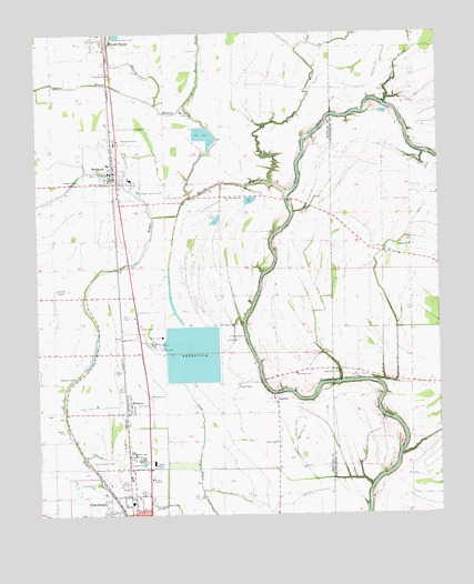
Merigold, MS USGS Topographic Map
Click on map above to begin viewing in our Map Viewer.

This topographic map contains these locations and features:
Feature Name Type Latitude Longitude GNIS ID View Map
Beaver BayouStreamN33.8357°W90.6762°666691View Map
Beaver CemeteryCemeteryN33.7687°W90.7368°666696View Map
Bethany ChurchChurchN33.8196°W90.6343°666870View Map
Bolivar County Fire Department District 1 Station 2 MerigoldBuildingN33.8384°W90.7258°2665652View Map
Brown CemeteryCemeteryN33.7873°W90.7262°667621View Map
Cleveland Industrial ParkLocaleN33.7551°W90.7079°687969View Map
Davis ChapelChurchN33.7690°W90.6762°669136View Map
Delta State Golf CourseLocaleN33.7529°W90.7270°687974View Map
Dorr FieldAirportN33.8473°W90.7246°680407View Map
Hyde BayouStreamN33.8562°W90.6415°671648View Map
Jerusalem ChurchChurchN33.8648°W90.7273°671861View Map
Joseph ChapelChurchN33.7837°W90.6879°672035View Map
Lampton ChapelChurchN33.8365°W90.7368°672292View Map
Little Mound BayouStreamN33.8559°W90.7037°672645View Map
Matthews Crossing (historical)LocaleN33.8168°W90.7251°710133View Map
MerigoldPopulated PlaceN33.8390°W90.7262°673494View Map
Merigold Police DepartmentBuildingN33.8383°W90.7258°2754219View Map
Merigold Post OfficePost OfficeN33.8387°W90.7251°2768573View Map
Merigold SchoolSchoolN33.8371°W90.7209°710134View Map
Merigold Sewage Lagoon DamDamN33.8334°W90.7168°682360View Map
Mississippi Power and Light Pond DamDamN33.7834°W90.7034°682339View Map
Mound BayouStreamN33.8332°W90.6712°673898View Map
New Cleveland CemeteryCemeteryN33.7640°W90.7340°674607View Map
New Morning Star ChurchChurchN33.8323°W90.6909°674780View Map
Old Cleveland CemeteryCemeteryN33.7582°W90.7320°675173View Map
Parks Chapel (historical)ChurchN33.8065°W90.7351°688080View Map
Pleasant Green ChurchChurchN33.8423°W90.6354°675974View Map
Providence ChurchChurchN33.7865°W90.6698°676391View Map
RenovaPopulated PlaceN33.7787°W90.7215°676603View Map
Renova School (historical)SchoolN33.7762°W90.7207°688085View Map
Riverside School (historical)SchoolN33.7798°W90.6337°686583View Map
Rose Hill ChurchChurchN33.7957°W90.7234°676865View Map
Saint Marys Church (historical)ChurchN33.8596°W90.6926°688089View Map
Shipmans ChapelChurchN33.7857°W90.7384°677724View Map
Smith CemeteryCemeteryN33.7784°W90.7190°677909View Map
Smith School (historical)SchoolN33.7871°W90.6723°688097View Map
Sunflower School (historical)SchoolN33.8209°W90.6340°686613View Map
Supervisor District 4CivilN33.7827°W90.7087°711786View Map
Town of MerigoldCivilN33.8391°W90.7264°2406148View Map
Town of RenovaCivilN33.7805°W90.7232°2407199View Map
Union Grove ChurchChurchN33.7876°W90.6573°679085View Map
White Cloud Chapel (historical)ChurchN33.8340°W90.6751°688102View Map
White Zion School (historical)SchoolN33.8507°W90.6668°688103View Map
Whites Chapel (historical)ChurchN33.8604°W90.6487°686623View Map
Wilnot Chapel (historical)ChurchN33.8296°W90.6737°688104View Map
WQAZ-FM (Cleveland)TowerN33.7534°W90.7126°680249View Map
WRDC-AM (Cleveland)TowerN33.7534°W90.7126°680147View Map
ZumbroPopulated PlaceN33.7796°W90.6762°680054View Map

Note: Coordinates in the location and feature list above are referenced to NAD83 datum.


Copyright (C) 2008-2025 Ryan Niemi / Sunset Dynamics ... All Rights Reserved