TopoQuest Logo
Do you find TopoQuest useful?
Help keep TopoQuest running and adding new maps/features by donating!
Bitcoin:  19c7KJd3qBynnjoSw5npx9KScwjBe4ifkT
Litecoin:  LXs6TkuXGGXo1vDsWCkWVdjQX94eUKd6ui
Home View Maps Find Maps Find Places Resources & Links


Kewaskum, Wisconsin Topographic Map

USGS Map Title: Kewaskum, WI
USGS Map MRC: 43088E2
DRG (GeoTIFF) Download: o43088e2.tif


Neighboring USGS Topographic Map Quads:


  Eden, WI  
43088F3
 

  Dundee, WI  
43088F2
 

  Cascade, WI  
43088F1
 

  Campbellsport, WI  
43088E3
 

  Kewaskum, WI  
43088E2
 

  Batavia, WI  
43088E1
 

  Allenton, WI  
43088D3
 

  West Bend, WI  
43088D2
 

  Newburg, WI  
43088D1


Map MRC Location:

N44°
W89°
N44°
W88°
H8 H7 H6 H5 H4 H3 H2 H1
G8 G7 G6 G5 G4 G3 G2 G1
F8 F7 F6 F5 F4 F3 F2 F1
E8 E7 E6 E5 E4 E3 E2 E1
D8 D7 D6 D5 D4 D3 D2 D1
C8 C7 C6 C5 C4 C3 C2 C1
B8 B7 B6 B5 B4 B3 B2 B1
A8 A7 A6 A5 A4 A3 A2 A1
N43°
W89°
N43°
W88°

Kewaskum, WI USGS 1:24K Topographic Map Preview:
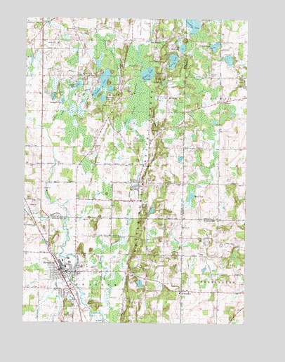
Kewaskum, WI USGS Topographic Map
Click on map above to begin viewing in our Map Viewer.

This topographic map contains these locations and features:
Feature Name Type Latitude Longitude GNIS ID View Map
Auburn LakeLakeN43.5987°W88.2067°1561006View Map
Auburn Lake CreekStreamN43.5792°W88.2382°1561007View Map
Buffalo-Trinity CemeteryCemeteryN43.5353°W88.2006°1562376View Map
Buttermilk LakeLakeN43.5919°W88.2064°1562477View Map
Butzke LakeLakeN43.5976°W88.2204°1562492View Map
Crooked LakeLakeN43.6230°W88.1564°1563550View Map
Dickman LakeLakeN43.5907°W88.2292°1563977View Map
East Valley School (historical)SchoolN43.5789°W88.1743°1845764View Map
Forest LakeLakeN43.6076°W88.1672°1565136View Map
Gage CemeteryCemeteryN43.5580°W88.2209°1565378View Map
Gage School (historical)SchoolN43.5575°W88.2201°1845805View Map
Haack LakeLakeN43.5521°W88.1560°1565950View Map
Haskell Noyes Memorial Woods State Natural AreaParkN43.6122°W88.1729°2059225View Map
Holy Trinity Catholic ChurchChurchN43.5206°W88.2251°1840928View Map
Holy Trinity Catholic SchoolSchoolN43.5203°W88.2249°1840929View Map
Hon-E-Kor Country ClubLocaleN43.5186°W88.2182°1840931View Map
Kettle Hole Woods State Natural AreaParkN43.5944°W88.1554°2055602View Map
Kettle Moraine Youth CampLocaleN43.5758°W88.1884°1567442View Map
KewaskumPopulated PlaceN43.5208°W88.2290°1567443View Map
Kewaskum Elementary SchoolSchoolN43.5228°W88.2247°1840937View Map
Kewaskum Fire DepartmentBuildingN43.5175°W88.2252°2697551View Map
Kewaskum High SchoolSchoolN43.5248°W88.2243°1840938View Map
Kewaskum Industrial ParkLocaleN43.5294°W88.2309°1840939View Map
Kewaskum Kiwanis ParkParkN43.5194°W88.2359°1840940View Map
Kewaskum Maple-Oak Woods State Natural AreaParkN43.5075°W88.2090°2059260View Map
Kewaskum Middle SchoolSchoolN43.5263°W88.2246°1840941View Map
Kewaskum MillpondReservoirN43.5174°W88.2230°2761840View Map
Kewaskum Police DepartmentBuildingN43.5221°W88.2270°2759370View Map
Kewaskum Sewage Treatment PlantLocaleN43.5142°W88.2217°2723895View Map
Lake Fifteen School (historical)SchoolN43.5972°W88.2123°1845840View Map
Lake SevenLakeN43.6138°W88.1435°1573911View Map
Little Mud LakeLakeN43.6130°W88.1619°1568326View Map
Mallard Hole LakeLakeN43.5987°W88.1724°1568916View Map
Mauthe LakeLakeN43.6022°W88.1814°1569136View Map
Mauthe Lake Recreation AreaParkN43.6006°W88.1782°1569137View Map
Milwaukee River and Swamp State Natural AreaParkN43.5981°W88.1879°2059226View Map
Milwaukee River Floodplain Forest State Natural AreaParkN43.5017°W88.1979°2059261View Map
New FanePopulated PlaceN43.5550°W88.1859°1570212View Map
New Fane MillpondLakeN43.5583°W88.1865°1570213View Map
New ProspectPopulated PlaceN43.6158°W88.1787°1570230View Map
New Prospect CemeteryCemeteryN43.6155°W88.1904°1570231View Map
Peace United Church of ChristChurchN43.5214°W88.2248°1840950View Map
River Hill ParkParkN43.5186°W88.2218°1840953View Map
Saint John Evangelical Lutheran ChurchChurchN43.5642°W88.1832°1573011View Map
Saint Johns CemeteryCemeteryN43.5642°W88.1826°1845912View Map
Saint Johns School (historical)SchoolN43.5639°W88.1834°1845915View Map
Saint Lucas Grade SchoolSchoolN43.5220°W88.2226°1840969View Map
Saint Lucas Lutheran ChurchChurchN43.5222°W88.2234°1840970View Map
Saint Mathias CemeteryCemeteryN43.5794°W88.1745°1845932View Map
Saint Matthias Catholic ChurchChurchN43.5789°W88.1751°1573363View Map
Saint Michael Catholic ChurchChurchN43.5122°W88.1618°1840972View Map
Saint MichaelsPopulated PlaceN43.5133°W88.1607°1573372View Map
Spring LakeLakeN43.5961°W88.2025°1574661View Map
Spring Lake State Natural AreaParkN43.5961°W88.2004°2059235View Map
Town of AuburnCivilN43.5866°W88.2195°1582730View Map
Town of KewaskumCivilN43.5135°W88.2200°1583474View Map
Village of KewaskumCivilN43.5176°W88.2306°1583473View Map
Virgin CreekStreamN43.5861°W88.2232°1576114View Map
Warden CemeteryCemeteryN43.6012°W88.1446°1576208View Map
Washington School (historical)SchoolN43.5206°W88.1445°1840989View Map
West Branch Milwaukee RiverStreamN43.5414°W88.2276°1576473View Map

Note: Coordinates in the location and feature list above are referenced to NAD83 datum.


Copyright (C) 2008-2025 Ryan Niemi / Sunset Dynamics ... All Rights Reserved