TopoQuest Logo
Do you find TopoQuest useful?
Help keep TopoQuest running and adding new maps/features by donating!
Bitcoin:  19c7KJd3qBynnjoSw5npx9KScwjBe4ifkT
Litecoin:  LXs6TkuXGGXo1vDsWCkWVdjQX94eUKd6ui
Home View Maps Find Maps Find Places Resources & Links


Durant Bend, Alabama Topographic Map

USGS Map Title: Durant Bend, AL
USGS Map MRC: 32086D7
DRG (GeoTIFF) Download: o32086d7.tif


Neighboring USGS Topographic Map Quads:


  Jones, AL  
32086E8
 

  Milton, AL  
32086E7
 

  Vida, AL  
32086E6
 

  Burnsville, AL  
32086D8
 

  Durant Bend, AL  
32086D7
 

  Autaugaville, AL  
32086D6
 

  Sardis, AL  
32086C8
 

  Benton, AL  
32086C7
 

  White Hall, AL  
32086C6


Map MRC Location:

N33°
W87°
N33°
W86°
H8 H7 H6 H5 H4 H3 H2 H1
G8 G7 G6 G5 G4 G3 G2 G1
F8 F7 F6 F5 F4 F3 F2 F1
E8 E7 E6 E5 E4 E3 E2 E1
D8 D7 D6 D5 D4 D3 D2 D1
C8 C7 C6 C5 C4 C3 C2 C1
B8 B7 B6 B5 B4 B3 B2 B1
A8 A7 A6 A5 A4 A3 A2 A1
N32°
W87°
N32°
W86°

Durant Bend, AL USGS 1:24K Topographic Map Preview:
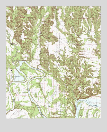
Durant Bend, AL USGS Topographic Map
Click on map above to begin viewing in our Map Viewer.

This topographic map contains these locations and features:
Feature Name Type Latitude Longitude GNIS ID View Map
Alabama State Docks FacilityLocaleN32.4146°W86.8694°144702View Map
Big Springs ChurchChurchN32.3876°W86.8150°114327View Map
Buck CreekStreamN32.4587°W86.8653°115122View Map
Cunningham BluffCliffN32.3849°W86.8664°144546View Map
Cunninghams Landing (historical)LocaleN32.3840°W86.8689°144547View Map
Durant BendBendN32.4174°W86.8475°117688View Map
Edwards BarBarN32.3882°W86.7539°136348View Map
Gardiner IslandIslandN32.4354°W86.8603°118826View Map
Gardners Landing (historical)LocaleN32.4360°W86.8630°144573View Map
Gaston BarBarN32.4262°W86.8258°144575View Map
Hammermill Waste Treatment DamDamN32.4251°W86.8567°130560View Map
Hammermill Waste Treatment PondReservoirN32.4218°W86.8589°130561View Map
Henderson LandingLocaleN32.3885°W86.7628°136370View Map
Ivy CreekStreamN32.3912°W86.7836°120732View Map
Ivy Creek United Methodist ChurchChurchN32.4599°W86.7822°151871View Map
Jim Adams LakeReservoirN32.3986°W86.8140°130518View Map
Jim Adams Lake DamDamN32.3951°W86.8150°130519View Map
Jones BluffCliffN32.3976°W86.7719°120975View Map
Jones CemeteryCemeteryN32.4237°W86.7603°120986View Map
Kalmia (historical)Populated PlaceN32.4029°W86.7944°147582View Map
Little Mulberry CreekStreamN32.4354°W86.8453°152106View Map
Lower Brother BarBarN32.4029°W86.8447°144606View Map
Mellards Chapel ChurchChurchN32.4618°W86.7697°147590View Map
Morgan BarBarN32.3779°W86.8269°144619View Map
MulberryPopulated PlaceN32.4596°W86.7764°156759View Map
Mulberry CreekStreamN32.4393°W86.8583°160202View Map
Old Hell BarBarN32.4310°W86.8369°147604View Map
PeacePopulated PlaceN32.4087°W86.7711°156860View Map
Perrys Landing (historical)LocaleN32.4371°W86.8458°147612View Map
Pine Grove ChurchChurchN32.4221°W86.7611°124790View Map
R E Bob Woodruff ParkParkN32.3974°W86.7833°147639View Map
River Bend ChurchChurchN32.3918°W86.7744°163499View Map
Saint Matthew ChurchChurchN32.4465°W86.8144°153274View Map
Selma State ParkParkN32.4112°W86.8675°144679View Map
StatesvillePopulated PlaceN32.4696°W86.8305°157106View Map
Steeles FarmLocaleN32.4029°W86.8236°147650View Map
Steels Mill (historical)LocaleN32.4037°W86.8255°147652View Map
Steezers FarmLocaleN32.4110°W86.8519°144692View Map
Underwood LakeReservoirN32.4714°W86.7651°130598View Map
Underwood Lake DamDamN32.4701°W86.7666°130597View Map
Upper Brother BarBarN32.3976°W86.8408°147662View Map

Note: Coordinates in the location and feature list above are referenced to NAD83 datum.


Copyright (C) 2008-2025 Ryan Niemi / Sunset Dynamics ... All Rights Reserved