TopoQuest Logo
Do you find TopoQuest useful?
Help keep TopoQuest running and adding new maps/features by donating!
Bitcoin:  19c7KJd3qBynnjoSw5npx9KScwjBe4ifkT
Litecoin:  LXs6TkuXGGXo1vDsWCkWVdjQX94eUKd6ui
Home View Maps Find Maps Find Places Resources & Links


White Hall, Alabama Topographic Map

USGS Map Title: White Hall, AL
USGS Map MRC: 32086C6
DRG (GeoTIFF) Download: o32086c6.tif


Neighboring USGS Topographic Map Quads:


  Durant Bend, AL  
32086D7
 

  Autaugaville, AL  
32086D6
 

  Forester, AL  
32086D5
 

  Benton, AL  
32086C7
 

  White Hall, AL  
32086C6
 

  Lowndesboro, AL  
32086C5
 

  Collirene, AL  
32086B7
 

  Gordonsville, AL  
32086B6
 

  Hayneville, AL  
32086B5


Map MRC Location:

N33°
W87°
N33°
W86°
H8 H7 H6 H5 H4 H3 H2 H1
G8 G7 G6 G5 G4 G3 G2 G1
F8 F7 F6 F5 F4 F3 F2 F1
E8 E7 E6 E5 E4 E3 E2 E1
D8 D7 D6 D5 D4 D3 D2 D1
C8 C7 C6 C5 C4 C3 C2 C1
B8 B7 B6 B5 B4 B3 B2 B1
A8 A7 A6 A5 A4 A3 A2 A1
N32°
W87°
N32°
W86°

White Hall, AL USGS 1:24K Topographic Map Preview:
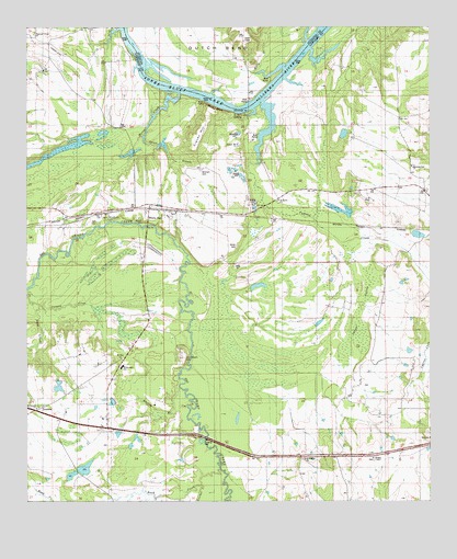
White Hall, AL USGS Topographic Map
Click on map above to begin viewing in our Map Viewer.

This topographic map contains these locations and features:
Feature Name Type Latitude Longitude GNIS ID View Map
B C Rhyne LakeReservoirN32.2572°W86.7362°130354View Map
B C Rhyne Lake DamDamN32.2568°W86.7350°130353View Map
Blue BluffCliffN32.3537°W86.6908°114528View Map
Buck CreekStreamN32.2585°W86.6905°115121View Map
C H Rhyne DamDamN32.2551°W86.7383°130352View Map
Cooper Branch Narrows Lake DamDamN32.3535°W86.6716°130477View Map
Cravey HillSummitN32.3474°W86.6958°116820View Map
Cypress CreekStreamN32.3554°W86.6766°116993View Map
De Bardeleben LandingLocaleN32.3518°W86.7003°136344View Map
Gordon Bend ChurchChurchN32.3482°W86.7461°136362View Map
Hoffman Rhyne LakeReservoirN32.2551°W86.7383°130351View Map
Holy Ground BarBarN32.3532°W86.6853°147577View Map
Hopewell ChurchChurchN32.2635°W86.6383°163492View Map
House CreekStreamN32.3576°W86.7028°155560View Map
Johnson HillSummitN32.2882°W86.7019°120950View Map
Lowndesboro DivisionCivilN32.3121°W86.6530°165857View Map
Milligans PondReservoirN32.3326°W86.6492°136400View Map
Mitchell CemeteryCemeteryN32.3371°W86.6958°122895View Map
Molly BranchStreamN32.3643°W86.6691°122939View Map
Morning Star SchoolSchoolN32.3379°W86.6294°123067View Map
Mount Zion SchoolSchoolN32.2882°W86.7205°123497View Map
Northwest Lowndes Division (historical)CensusN32.3124°W86.6675°1935000View Map
Panther CreekStreamN32.2543°W86.6958°124419View Map
Pilot CreekStreamN32.3060°W86.7497°124748View Map
Pleasant Green ChurchChurchN32.3735°W86.7480°124935View Map
Powells Ferry (historical)CrossingN32.3535°W86.6833°147617View Map
Roland Industrial School (historical)SchoolN32.2701°W86.7278°136444View Map
Saint Marks ChurchChurchN32.3296°W86.6719°126160View Map
Saint Marks ChurchChurchN32.3088°W86.6822°136449View Map
Sanctified ChurchChurchN32.2532°W86.7289°126291View Map
Sawyer SwampSwampN32.2937°W86.6488°126451View Map
Selma to Montgomery National Historic TrailParkN32.2708°W86.7282°2733435View Map
Spratt BranchStreamN32.3576°W86.7025°127207View Map
The Narrows LakeReservoirN32.3535°W86.6716°130476View Map
Town of White HallCivilN32.2993°W86.7148°2406877View Map
TrickemPopulated PlaceN32.2735°W86.7469°155278View Map
Unity ChurchChurchN32.3249°W86.7241°136469View Map
Whatley BranchStreamN32.2801°W86.7025°128820View Map
White CemeteryCemeteryN32.3174°W86.6847°128864View Map
White HallPopulated PlaceN32.3271°W86.7119°153961View Map
White Hall Elementary SchoolSchoolN32.2854°W86.7208°165609View Map
White Hall Volunteer Fire DepartmentBuildingN32.3280°W86.7124°2691572View Map
Wright ChapelChurchN32.2613°W86.6425°154038View Map

Note: Coordinates in the location and feature list above are referenced to NAD83 datum.


Copyright (C) 2008-2025 Ryan Niemi / Sunset Dynamics ... All Rights Reserved