TopoQuest Logo
Do you find TopoQuest useful?
Help keep TopoQuest running and adding new maps/features by donating!
Bitcoin:  19c7KJd3qBynnjoSw5npx9KScwjBe4ifkT
Litecoin:  LXs6TkuXGGXo1vDsWCkWVdjQX94eUKd6ui
Home View Maps Find Maps Find Places Resources & Links


Green Bank, West Virginia Topographic Map

USGS Map Title: Green Bank, WV
USGS Map MRC: 38079D7
DRG (GeoTIFF) Download: o38079d7.tif


Neighboring USGS Topographic Map Quads:


  Snyder Knob, WV  
38079E8
 

  Durbin, WV  
38079E7
 

  Thornwood, WV  
38079E6
 

  Cass, WV  
38079D8
 

  Green Bank, WV  
38079D7
 

  Hightown, VA  
38079D6
 

  Clover Lick, WV  
38079C8
 

  Paddy Knob, WV  
38079C7
 

  Mustoe, VA  
38079C6


Map MRC Location:

N39°
W80°
N39°
W79°
H8 H7 H6 H5 H4 H3 H2 H1
G8 G7 G6 G5 G4 G3 G2 G1
F8 F7 F6 F5 F4 F3 F2 F1
E8 E7 E6 E5 E4 E3 E2 E1
D8 D7 D6 D5 D4 D3 D2 D1
C8 C7 C6 C5 C4 C3 C2 C1
B8 B7 B6 B5 B4 B3 B2 B1
A8 A7 A6 A5 A4 A3 A2 A1
N38°
W80°
N38°
W79°

Green Bank, WV USGS 1:24K Topographic Map Preview:
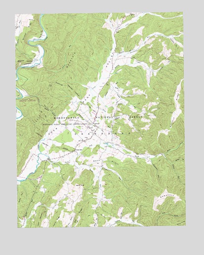
Green Bank, WV USGS Topographic Map
Click on map above to begin viewing in our Map Viewer.

This topographic map contains these locations and features:
Feature Name Type Latitude Longitude GNIS ID View Map
Allegheny RunStreamN38.4698°W79.8623°1550091View Map
ArbovalePopulated PlaceN38.4354°W79.8176°1553737View Map
Arbovale CemeteryCemeteryN38.4348°W79.8206°1727992View Map
Arbovale Census Designated PlaceCensusN38.4354°W79.8117°2586755View Map
Arbovale Post OfficePost OfficeN38.4340°W79.8159°1727993View Map
Arbovale United Methodist ChurchChurchN38.4357°W79.8170°1727994View Map
Asbury KnobSummitN38.3996°W79.8289°1553756View Map
Back DraftStreamN38.4112°W79.8214°1550134View Map
Bartow - Frank - Durbin Fire and Rescue 2BuildingN38.4288°W79.8174°2577661View Map
Bearpen HollowValleyN38.4118°W79.7595°1550205View Map
Big RidgeRidgeN38.3768°W79.8323°1550308View Map
Bowman RidgeRidgeN38.4904°W79.8634°1550435View Map
BoyerPopulated PlaceN38.4890°W79.8006°1553957View Map
Boyer School (historical)SchoolN38.4904°W79.7978°1728007View Map
Buffalo RidgeRidgeN38.4537°W79.7553°1550544View Map
Buffalo Ridge School (historical)SchoolN38.4440°W79.7553°1728017View Map
Buffalo RunStreamN38.4618°W79.8126°1550545View Map
Cooper RunStreamN38.4054°W79.8170°1550790View Map
Deer Creek Farm AirportAirportN38.4709°W79.8059°2443467View Map
Deer Creek Union Church (historical)ChurchN38.4351°W79.8198°1728038View Map
Deer Creek ValleyValleyN38.4043°W79.8723°1550901View Map
Duncan RunStreamN38.4504°W79.8089°1553669View Map
Green BankPopulated PlaceN38.4201°W79.8314°1551282View Map
Green Bank Census Designated PlaceCensusN38.4267°W79.8344°2586818View Map
Green Bank Elementary - Middle SchoolSchoolN38.4254°W79.8258°1728069View Map
Green Bank Post OfficePost OfficeN38.4193°W79.8319°1728070View Map
Green Bank Public LibraryBuildingN38.4314°W79.8165°2727362View Map
Green Bank United Methodist ChurchChurchN38.4193°W79.8306°1728071View Map
Hamilton HollowValleyN38.4146°W79.7745°1728077View Map
Hamilton RunStreamN38.4148°W79.7751°1551336View Map
Hevener ChurchChurchN38.4923°W79.8742°1551414View Map
Hospital RunStreamN38.4418°W79.8317°1551508View Map
HostermanPopulated PlaceN38.4732°W79.8617°1554747View Map
Kerr Memorial ChurchChurchN38.4904°W79.7981°1728093View Map
Kerr School (historical)SchoolN38.4737°W79.7870°1728094View Map
Lambs RunStreamN38.4568°W79.8017°1551690View Map
Lamp of Youth Christian AcademySchoolN38.4169°W79.8372°2487420View Map
Laurel RunStreamN38.4710°W79.8564°1551727View Map
Liberty ChurchChurchN38.4262°W79.8220°1551782View Map
Little MountainRidgeN38.4579°W79.8498°1553550View Map
Little Mountain TrailTrailN38.4779°W79.8406°1551881View Map
Millstone RunStreamN38.4401°W79.8087°1552156View Map
National Radio Astronomy ObservatoryLocaleN38.4379°W79.8362°1553670View Map
North ForkStreamN38.4185°W79.8567°1552320View Map
North Fork School (historical)SchoolN38.4176°W79.7820°1728129View Map
NRAO Green Bank AirportAirportN38.4312°W79.8265°1558798View Map
Oak Grove School (historical)SchoolN38.3985°W79.8170°1728131View Map
Oak Hill School (historical)SchoolN38.4415°W79.7864°1728133View Map
Old House KnobSummitN38.4726°W79.8731°1555264View Map
Pine Grove ChurchChurchN38.4462°W79.7995°1552481View Map
Pine Grove School (historical)SchoolN38.4465°W79.7998°1728137View Map
RamshornRidgeN38.3910°W79.7551°1553555View Map
Riley RunStreamN38.4479°W79.8203°1552667View Map
Rosen RunStreamN38.4126°W79.8376°1552735View Map
Salisbury School (historical)SchoolN38.4854°W79.7626°1728154View Map
Saulsbury RunStreamN38.4751°W79.8053°1552806View Map
Shingleblock RunStreamN38.4857°W79.7612°1552871View Map
Slavin HollowValleyN38.4396°W79.8437°1552927View Map
Smith HollowValleyN38.3782°W79.8706°1552938View Map
Sugar RunStreamN38.3782°W79.7981°1553120View Map
Sutton RunStreamN38.4171°W79.7653°1553148View Map
Tacker ForkStreamN38.4240°W79.7512°1553170View Map
Trimble RunStreamN38.4554°W79.8053°1553259View Map
Upper MountainSummitN38.3843°W79.8553°1553327View Map

Note: Coordinates in the location and feature list above are referenced to NAD83 datum.


Copyright (C) 2008-2024 Ryan Niemi / Sunset Dynamics ... All Rights Reserved