TopoQuest Logo
Do you find TopoQuest useful?
Help keep TopoQuest running and adding new maps/features by donating!
Bitcoin:  19c7KJd3qBynnjoSw5npx9KScwjBe4ifkT
Litecoin:  LXs6TkuXGGXo1vDsWCkWVdjQX94eUKd6ui
Home View Maps Find Maps Find Places Resources & Links


Eagle Rock, Missouri Topographic Map

USGS Map Title: Eagle Rock, MO
USGS Map MRC: 36093E7
DRG (GeoTIFF) Download: o36093e7.tif


Neighboring USGS Topographic Map Quads:


  Exeter, MO  
36093F8
 

  Cassville, MO  
36093F7
 

  Shell Knob, MO  
36093F6
 

  Seligman, MO  
36093E8
 

  Eagle Rock, MO  
36093E7
 

  Golden, MO  
36093E6
 

  Garfield, AR  
36093D8
 

  Beaver, AR  
36093D7
 

  Eureka Springs, AR  
36093D6


Map MRC Location:

N37°
W94°
N37°
W93°
H8 H7 H6 H5 H4 H3 H2 H1
G8 G7 G6 G5 G4 G3 G2 G1
F8 F7 F6 F5 F4 F3 F2 F1
E8 E7 E6 E5 E4 E3 E2 E1
D8 D7 D6 D5 D4 D3 D2 D1
C8 C7 C6 C5 C4 C3 C2 C1
B8 B7 B6 B5 B4 B3 B2 B1
A8 A7 A6 A5 A4 A3 A2 A1
N36°
W94°
N36°
W93°

Eagle Rock, MO USGS 1:24K Topographic Map Preview:
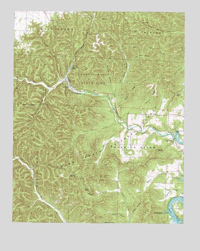
Eagle Rock, MO USGS Topographic Map
Click on map above to begin viewing in our Map Viewer.

This topographic map contains these locations and features:
Feature Name Type Latitude Longitude GNIS ID View Map
Accident School (historical)SchoolN36.6247°W93.7519°2710110View Map
Butler School (historical)SchoolN36.5347°W93.8684°2710109View Map
Camp OpbocaLocaleN36.6206°W93.8074°749181View Map
Cassville Natural BridgeArchN36.6189°W93.7817°751263View Map
CCC CampLocaleN36.5790°W93.8258°753308View Map
Chute RidgeRidgeN36.5781°W93.7866°749360View Map
Dry HollowValleyN36.5859°W93.8358°749733View Map
Eagle RockPopulated PlaceN36.5481°W93.7544°749762View Map
Eagle Rock Post OfficePost OfficeN36.5467°W93.7559°2783084View Map
Haddock CreekStreamN36.5012°W93.7502°750185View Map
Hottle BranchStreamN36.5042°W93.7885°750404View Map
Ketchum HollowValleyN36.5770°W93.8005°750597View Map
Log Cabin HollowValleyN36.5937°W93.7894°750815View Map
Mount Zion School (historical)SchoolN36.5253°W93.7710°753306View Map
Munsey CemeteryCemeteryN36.5576°W93.7894°751238View Map
Munsey School (historical)SchoolN36.5578°W93.7908°753307View Map
Off Davis HollowValleyN36.5728°W93.8030°751410View Map
Onyx Cave Picnic AreaLocaleN36.5281°W93.8083°754415View Map
Pelican MountainSummitN36.5434°W93.7677°751539View Map
Piber HollowValleyN36.5840°W93.8402°751575View Map
Pine HollowValleyN36.5595°W93.7980°751611View Map
Radium HollowValleyN36.5178°W93.7941°751794View Map
Radium SpringSpringN36.5198°W93.8216°751795View Map
Reed HollowValleyN36.5573°W93.7924°751841View Map
Roaring River HollowValleyN36.5859°W93.8358°751907View Map
Roaring River School (historical)SchoolN36.5848°W93.8394°753309View Map
Roaring River SpringSpringN36.5915°W93.8319°751908View Map
Roaring River State ParkParkN36.5856°W93.8158°751909View Map
Seligman HollowValleyN36.5787°W93.8483°752076View Map
Sugar Camp Lookout TowerTowerN36.5284°W93.8327°755418View Map
Talbert Fire Tower (historical)TowerN36.5873°W93.7680°755461View Map
Township of Roaring RiverCivilN36.5637°W93.7552°766268View Map
Walnut RidgeRidgeN36.5759°W93.7702°752748View Map
Wolfpen GapGapN36.5760°W93.7566°752961View Map

Note: Coordinates in the location and feature list above are referenced to NAD83 datum.


Copyright (C) 2008-2025 Ryan Niemi / Sunset Dynamics ... All Rights Reserved