TopoQuest Logo
Do you find TopoQuest useful?
Help keep TopoQuest running and adding new maps/features by donating!
Bitcoin:  19c7KJd3qBynnjoSw5npx9KScwjBe4ifkT
Litecoin:  LXs6TkuXGGXo1vDsWCkWVdjQX94eUKd6ui
Home View Maps Find Maps Find Places Resources & Links


Golden, Missouri Topographic Map

USGS Map Title: Golden, MO
USGS Map MRC: 36093E6
DRG (GeoTIFF) Download: o36093e6.tif


Neighboring USGS Topographic Map Quads:


  Cassville, MO  
36093F7
 

  Shell Knob, MO  
36093F6
 

  Cape Fair, MO  
36093F5
 

  Eagle Rock, MO  
36093E7
 

  Golden, MO  
36093E6
 

  Viola, MO  
36093E5
 

  Beaver, AR  
36093D7
 

  Eureka Springs, AR  
36093D6
 

  Grandview, AR  
36093D5


Map MRC Location:

N37°
W94°
N37°
W93°
H8 H7 H6 H5 H4 H3 H2 H1
G8 G7 G6 G5 G4 G3 G2 G1
F8 F7 F6 F5 F4 F3 F2 F1
E8 E7 E6 E5 E4 E3 E2 E1
D8 D7 D6 D5 D4 D3 D2 D1
C8 C7 C6 C5 C4 C3 C2 C1
B8 B7 B6 B5 B4 B3 B2 B1
A8 A7 A6 A5 A4 A3 A2 A1
N36°
W94°
N36°
W93°

Golden, MO USGS 1:24K Topographic Map Preview:
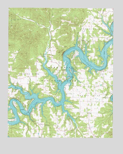
Golden, MO USGS Topographic Map
Click on map above to begin viewing in our Map Viewer.

This topographic map contains these locations and features:
Feature Name Type Latitude Longitude GNIS ID View Map
Bel-Voir Acres AirportAirportN36.5632°W93.6382°758695View Map
Brock School (historical)SchoolN36.5942°W93.6496°732893View Map
Calloway Ford (historical)CrossingN36.5134°W93.7466°753413View Map
Carter BranchStreamN36.5787°W93.6580°749231View Map
Cedar BranchStreamN36.5878°W93.6685°749281View Map
Cedar HollowValleyN36.5220°W93.7246°749301View Map
Central Crossing Fire Protection District Station 1BuildingN36.6169°W93.6478°2620643View Map
Chain-O-LakesPopulated PlaceN36.5345°W93.7249°1669592View Map
Coral Fountain ChapelChurchN36.5115°W93.7063°749471View Map
Cotner Ford (historical)CrossingN36.5356°W93.6838°753409View Map
Darity BranchStreamN36.5312°W93.6938°749566View Map
Eagle Rock - Golden - Mano Fire Department Station 1BuildingN36.5323°W93.7312°2620601View Map
Eagle Rock - Golden - Mano Fire Department Station 3BuildingN36.5636°W93.6891°2621422View Map
Eagle Rock - Golden - Mano Fire Department Station 4BuildingN36.5457°W93.6466°2621423View Map
Eagle Rock Census Designated PlaceCensusN36.5498°W93.7417°2587065View Map
Eagle Rock Public Use AreaParkN36.5273°W93.7302°749763View Map
Eagles Nest AirportAirportN36.5208°W93.6828°2679337View Map
Easley CemeteryCemeteryN36.5498°W93.7366°749766View Map
Easley Ford (historical)CrossingN36.5326°W93.7205°753411View Map
East Fork Rock CreekStreamN36.6056°W93.7007°749778View Map
East Fork School (historical)SchoolN36.6098°W93.6999°753404View Map
Emerald BeachPopulated PlaceN36.5756°W93.6719°1669593View Map
Garner HollowValleyN36.5503°W93.7460°750023View Map
GoldenPopulated PlaceN36.5242°W93.6538°750065View Map
Golden Census Designated PlaceCensusN36.5266°W93.6636°2587074View Map
Golden Ford (historical)CrossingN36.5531°W93.6821°753408View Map
Golden Post OfficePost OfficeN36.5238°W93.6542°2782755View Map
Golden School (historical)SchoolN36.5245°W93.6552°732894View Map
Highway M Public Use AreaParkN36.5578°W93.6769°750323View Map
Johns BranchStreamN36.5151°W93.7366°750517View Map
Ledgerwood HollowValleyN36.6167°W93.6377°750675View Map
Lewis Ford (historical)CrossingN36.5253°W93.7416°753412View Map
Liberty Church (historical)ChurchN36.5056°W93.6360°753414View Map
ManoPopulated PlaceN36.5770°W93.6977°750917View Map
Mano School (historical)SchoolN36.5762°W93.6988°732892View Map
Moccasin GapGapN36.5871°W93.6837°751137View Map
Natural Bridge HollowValleyN36.6148°W93.7346°751264View Map
New Hope School (historical)SchoolN36.5640°W93.6280°753406View Map
OakhillPopulated PlaceN36.5009°W93.7102°751399View Map
Owl CreekStreamN36.5323°W93.6863°53109View Map
Panther CreekStreamN36.5342°W93.7069°751485View Map
Raridan BranchStreamN36.5423°W93.7202°751808View Map
Roach CemeteryCemeteryN36.5151°W93.7066°751902View Map
Roach School (historical)SchoolN36.5115°W93.7063°753230View Map
Roaring RiverStreamN36.5378°W93.7163°751906View Map
Rock CreekStreamN36.5470°W93.6869°751923View Map
Rock Creek ChurchChurchN36.5842°W93.6996°751925View Map
Sawmill HollowValleyN36.5181°W93.7480°752040View Map
Smith Ford (historical)CrossingN36.5667°W93.6471°753405View Map
Steep BluffCliffN36.5820°W93.6838°752347View Map
Stubblefield BranchStreamN36.5195°W93.7405°752405View Map
Table Rock AirportAirportN36.5285°W93.6755°758694View Map
Township of White RiverCivilN36.5450°W93.6313°766273View Map
Turkey MountainSummitN36.5831°W93.6857°752607View Map
Turkey Mountain Estates AirportAirportN36.5928°W93.6641°758938View Map
Victory School (historical)SchoolN36.5503°W93.7132°753410View Map
Village of Chain-O-LakesCivilN36.5342°W93.7242°2397597View Map
Village of Emerald BeachCivilN36.5756°W93.6711°2398826View Map
Viney CemeteryCemeteryN36.5531°W93.6652°752716View Map
Viney CreekStreamN36.5684°W93.6760°752717View Map
Viney Creek Public Use AreaParkN36.5662°W93.6760°752718View Map
Viney School (historical)SchoolN36.5537°W93.6682°753407View Map

Note: Coordinates in the location and feature list above are referenced to NAD83 datum.


Copyright (C) 2008-2024 Ryan Niemi / Sunset Dynamics ... All Rights Reserved