TopoQuest Logo
Do you find TopoQuest useful?
Help keep TopoQuest running and adding new maps/features by donating!
Bitcoin:  19c7KJd3qBynnjoSw5npx9KScwjBe4ifkT
Litecoin:  LXs6TkuXGGXo1vDsWCkWVdjQX94eUKd6ui
Home View Maps Find Maps Find Places Resources & Links


Eagles Mere, Pennsylvania Topographic Map

USGS Map Title: Eagles Mere, PA
USGS Map MRC: 41076D5
DRG (GeoTIFF) Download: o41076d5.tif


Neighboring USGS Topographic Map Quads:


  Shunk, PA  
41076E6
 

  Overton, PA  
41076E5
 

  Dushore, PA  
41076E4
 

  Hillsgrove, PA  
41076D6
 

  Eagles Mere, PA  
41076D5
 

  Laporte, PA  
41076D4
 

  Picture Rocks, PA  
41076C6
 

  Sonestown, PA  
41076C5
 

  Elk Grove, PA  
41076C4


Map MRC Location:

N42°
W77°
N42°
W76°
H8 H7 H6 H5 H4 H3 H2 H1
G8 G7 G6 G5 G4 G3 G2 G1
F8 F7 F6 F5 F4 F3 F2 F1
E8 E7 E6 E5 E4 E3 E2 E1
D8 D7 D6 D5 D4 D3 D2 D1
C8 C7 C6 C5 C4 C3 C2 C1
B8 B7 B6 B5 B4 B3 B2 B1
A8 A7 A6 A5 A4 A3 A2 A1
N41°
W77°
N41°
W76°

Eagles Mere, PA USGS 1:24K Topographic Map Preview:
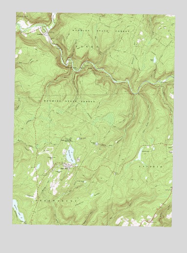
Eagles Mere, PA USGS Topographic Map
Click on map above to begin viewing in our Map Viewer.

This topographic map contains these locations and features:
Feature Name Type Latitude Longitude GNIS ID View Map
Ash Ridge SpurTrailN41.4942°W76.5416°1198338View Map
Bear RunStreamN41.4637°W76.5008°1198378View Map
Big RunStreamN41.4701°W76.5619°1198434View Map
Big Run SpurTrailN41.4795°W76.5502°1198437View Map
Big Timber SpurTrailN41.4751°W76.5380°1206242View Map
Borough of Eagles MereCivilN41.4102°W76.5832°1215604View Map
Borough of ForksvilleCivilN41.4896°W76.6028°1215605View Map
Canyon VistaPopulated PlaceN41.4662°W76.5647°1203220View Map
Castle RockPillarN41.4026°W76.5647°1201393View Map
Celestial LakeLakeN41.4187°W76.5251°1198550View Map
Chestnut RidgeRidgeN41.3909°W76.5652°1198564View Map
Coal RunStreamN41.4609°W76.5211°1198582View Map
Cold Run Road FallsFallsN41.4601°W76.5738°1201387View Map
Crane SpurTrailN41.4831°W76.5433°1198617View Map
CrestmontPopulated PlaceN41.4140°W76.5738°1197369View Map
Crestmont Post Office (historical)Post OfficeN41.4140°W76.5738°2027114View Map
Devils GardenRidgeN41.4509°W76.5622°1201315View Map
Double RunStreamN41.4670°W76.5783°1198658View Map
Double Run TrailTrailN41.4567°W76.5861°1206238View Map
Eagles MerePopulated PlaceN41.4109°W76.5819°1213962View Map
Eagles Mere Chautauqua Post Office (historical)Post OfficeN41.4109°W76.5819°2027111View Map
Eagles Mere FieldAirportN41.3923°W76.6067°1194226View Map
Eagles Mere FieldAirportN41.4206°W76.5320°2717245View Map
Eagles Mere Golf CourseLocaleN41.4187°W76.5994°1206239View Map
Eagles Mere LakeLakeN41.4161°W76.5797°1198686View Map
Eagles Mere ParkPopulated PlaceN41.4251°W76.5808°1198687View Map
Eagles Mere Post OfficePost OfficeN41.4103°W76.5836°2773127View Map
Eagles Mere Volunteer Fire Company Station 51BuildingN41.4091°W76.5808°2653493View Map
ForksvillePopulated PlaceN41.4870°W76.6022°1198754View Map
Forksville Post OfficePost OfficeN41.4880°W76.6013°2772703View Map
Forksville Volunteer Fire Company Station 53BuildingN41.4869°W76.6026°2653489View Map
Fox Hollow SpurTrailN41.4987°W76.5383°1198767View Map
HaystacksBarN41.4629°W76.5033°1201311View Map
High Rock RunStreamN41.4734°W76.5811°1198886View Map
High Rock SpurTrailN41.4915°W76.5802°1198887View Map
Hunters LakeLakeN41.3767°W76.6213°1198919View Map
Hunters Lake DamDamN41.3767°W76.6213°1195514View Map
Irish Settlement TrailTrailN41.4826°W76.5027°1198927View Map
LabyrinthPillarN41.4634°W76.5641°1201305View Map
Little Loyalsock CreekStreamN41.4917°W76.6097°1199897View Map
Lovers RockSummitN41.4167°W76.5774°1201392View Map
Loyalsock TrailTrailN41.4176°W76.6108°1199902View Map
Mackeys RunStreamN41.3854°W76.5916°1199102View Map
Merritt FieldAirportN41.4207°W76.5320°2630502View Map
Mill CreekStreamN41.4601°W76.5102°1199908View Map
Pole Bridge RunStreamN41.4540°W76.5274°1199323View Map
Pole Bridge TrailTrailN41.4417°W76.5230°1206240View Map
Pole HillSummitN41.4529°W76.5163°1201666View Map
Prospect HillSummitN41.4148°W76.5911°1199341View Map
Rainbow LakeLakeN41.4235°W76.5596°1199350View Map
Rock GardenAreaN41.4609°W76.5680°1202370View Map
Rock Run TrailTrailN41.4770°W76.5216°1206241View Map
Rusty RunStreamN41.4223°W76.5452°1199427View Map
Shanerburg RunStreamN41.4531°W76.5305°1199512View Map
Sones PondReservoirN41.4733°W76.5151°1199560View Map
Sones Pond DamDamN41.4717°W76.5147°1195602View Map
Sugar Camp SpurRidgeN41.4987°W76.5566°1199636View Map
Sullivan CountyCivilN41.4462°W76.5121°1213687View Map
Sullivan Highland SchoolSchoolN41.4062°W76.5819°1197368View Map
Tamarack RunStreamN41.4604°W76.5349°1199660View Map
Township of ShrewsburyCivilN41.3941°W76.6134°1217075View Map
Wenonan FallsFallsN41.3754°W76.5869°1199759View Map
World End TrailTrailN41.4759°W76.6030°1199816View Map
Worlds End State ParkParkN41.4713°W76.5686°1200134View Map
Wrights ViewPopulated PlaceN41.3779°W76.5158°1204997View Map

Note: Coordinates in the location and feature list above are referenced to NAD83 datum.


Copyright (C) 2008-2024 Ryan Niemi / Sunset Dynamics ... All Rights Reserved