TopoQuest Logo
Do you find TopoQuest useful?
Help keep TopoQuest running and adding new maps/features by donating!
Bitcoin:  19c7KJd3qBynnjoSw5npx9KScwjBe4ifkT
Litecoin:  LXs6TkuXGGXo1vDsWCkWVdjQX94eUKd6ui
Home View Maps Find Maps Find Places Resources & Links


Laporte, Pennsylvania Topographic Map

USGS Map Title: Laporte, PA
USGS Map MRC: 41076D4
DRG (GeoTIFF) Download: o41076d4.tif


Neighboring USGS Topographic Map Quads:


  Overton, PA  
41076E5
 

  Dushore, PA  
41076E4
 

  Colley, PA  
41076E3
 

  Eagles Mere, PA  
41076D5
 

  Laporte, PA  
41076D4
 

  Lopez, PA  
41076D3
 

  Sonestown, PA  
41076C5
 

  Elk Grove, PA  
41076C4
 

  Red Rock, PA  
41076C3


Map MRC Location:

N42°
W77°
N42°
W76°
H8 H7 H6 H5 H4 H3 H2 H1
G8 G7 G6 G5 G4 G3 G2 G1
F8 F7 F6 F5 F4 F3 F2 F1
E8 E7 E6 E5 E4 E3 E2 E1
D8 D7 D6 D5 D4 D3 D2 D1
C8 C7 C6 C5 C4 C3 C2 C1
B8 B7 B6 B5 B4 B3 B2 B1
A8 A7 A6 A5 A4 A3 A2 A1
N41°
W77°
N41°
W76°

Laporte, PA USGS 1:24K Topographic Map Preview:
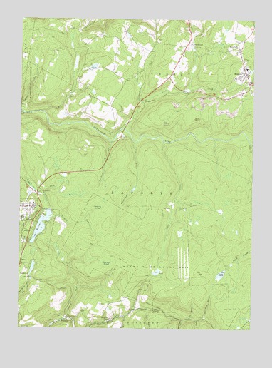
Laporte, PA USGS Topographic Map
Click on map above to begin viewing in our Map Viewer.

This topographic map contains these locations and features:
Feature Name Type Latitude Longitude GNIS ID View Map
BernicePopulated PlaceN41.4704°W76.3816°1198419View Map
Big RunStreamN41.3801°W76.4438°1198435View Map
Birch CreekStreamN41.4562°W76.4447°1198444View Map
Black HollowValleyN41.3826°W76.4213°1197659View Map
Borough of LaporteCivilN41.4180°W76.4920°1215606View Map
Conklin RunStreamN41.4195°W76.4827°1198594View Map
Cranberry SwampSwampN41.4239°W76.4575°1198616View Map
Dry HollowValleyN41.3795°W76.4075°1198662View Map
Dutchman FallsFallsN41.4501°W76.4505°1201447View Map
Dutchman RunStreamN41.4504°W76.4508°1198679View Map
Dutchman SwampSwampN41.4015°W76.4524°1198680View Map
Elklick RunStreamN41.3784°W76.4749°1198704View Map
Ellis CreekStreamN41.4504°W76.3758°1198706View Map
Floodwood CreekStreamN41.4509°W76.4363°1198745View Map
Foley CornerPopulated PlaceN41.4767°W76.4197°1203602View Map
Glass CreekStreamN41.4506°W76.4227°1198806View Map
Glass Creek ClubLocaleN41.3909°W76.4305°1197365View Map
Glass Creek DamDamN41.4117°W76.4213°1195556View Map
Glass Creek PondReservoirN41.4117°W76.4213°1195555View Map
Glass Creek PondLakeN41.3979°W76.4256°1198807View Map
Haystacks RapidsRapidsN41.4571°W76.4831°1201667View Map
Lake AkelaLakeN41.4807°W76.4609°1198325View Map
Lake Mokoma DamDamN41.4234°W76.4847°1195568View Map
LaportePopulated PlaceN41.4240°W76.4941°1198996View Map
Laporte Post OfficePost OfficeN41.4240°W76.4920°2773176View Map
Laporte Volunteer Fire Company Station 50BuildingN41.4249°W76.4920°2653579View Map
Lopez PondLakeN41.3973°W76.3908°1199086View Map
Lopez Pond BranchStreamN41.3792°W76.4002°1199087View Map
MildredPopulated PlaceN41.4781°W76.3783°1199153View Map
Mildred Post OfficePost OfficeN41.4779°W76.3784°2772833View Map
Mildred Volunteer Fire Company Station 58BuildingN41.4782°W76.3779°2653487View Map
Mill RunStreamN41.4626°W76.4869°1199162View Map
Mokoma LakeReservoirN41.4163°W76.4880°1199178View Map
Muncy CreekStreamN41.3759°W76.3819°1202628View Map
NordmontPopulated PlaceN41.3792°W76.4738°1199228View Map
Nordmont CampLocaleN41.3787°W76.4508°1199229View Map
Pennsylvania State Police Troop P Laporte StationBuildingN41.4268°W76.4896°2777246View Map
Peters CreekStreamN41.3826°W76.4374°1199295View Map
RingdalePopulated PlaceN41.4523°W76.4455°1199388View Map
Rock RunStreamN41.4665°W76.4330°1199401View Map
Rock RunStreamN41.3790°W76.4116°1199950View Map
Saint Francis ChurchChurchN41.4834°W76.3797°1199438View Map
Saint Pauls ChurchChurchN41.3787°W76.4708°1199467View Map
Sand RunStreamN41.4292°W76.4877°1199479View Map
SatterfieldPopulated PlaceN41.4904°W76.4086°1199486View Map
ShinervillePopulated PlaceN41.4876°W76.3819°1199523View Map
South Branch Rock RunStreamN41.3787°W76.4044°1199565View Map
Sullivan DamDamN41.4767°W76.3763°1195612View Map
SummitLocaleN41.3967°W76.4952°1199649View Map
ThorndalePopulated PlaceN41.4245°W76.4208°1204810View Map
Township of LaporteCivilN41.4155°W76.4559°1217074View Map
Trinity ChurchChurchN41.4815°W76.3797°1199692View Map
Tublick RunStreamN41.3829°W76.4308°1199702View Map

Note: Coordinates in the location and feature list above are referenced to NAD83 datum.


Copyright (C) 2008-2025 Ryan Niemi / Sunset Dynamics ... All Rights Reserved