TopoQuest Logo
Do you find TopoQuest useful?
Help keep TopoQuest running and adding new maps/features by donating!
Bitcoin:  19c7KJd3qBynnjoSw5npx9KScwjBe4ifkT
Litecoin:  LXs6TkuXGGXo1vDsWCkWVdjQX94eUKd6ui
Home View Maps Find Maps Find Places Resources & Links


Overton, Pennsylvania Topographic Map

USGS Map Title: Overton, PA
USGS Map MRC: 41076E5
DRG (GeoTIFF) Download: o41076e5.tif


Neighboring USGS Topographic Map Quads:


  Leroy, PA  
41076F6
 

  Powell, PA  
41076F5
 

  Monroeton, PA  
41076F4
 

  Shunk, PA  
41076E6
 

  Overton, PA  
41076E5
 

  Dushore, PA  
41076E4
 

  Hillsgrove, PA  
41076D6
 

  Eagles Mere, PA  
41076D5
 

  Laporte, PA  
41076D4


Map MRC Location:

N42°
W77°
N42°
W76°
H8 H7 H6 H5 H4 H3 H2 H1
G8 G7 G6 G5 G4 G3 G2 G1
F8 F7 F6 F5 F4 F3 F2 F1
E8 E7 E6 E5 E4 E3 E2 E1
D8 D7 D6 D5 D4 D3 D2 D1
C8 C7 C6 C5 C4 C3 C2 C1
B8 B7 B6 B5 B4 B3 B2 B1
A8 A7 A6 A5 A4 A3 A2 A1
N41°
W77°
N41°
W76°

Overton, PA USGS 1:24K Topographic Map Preview:
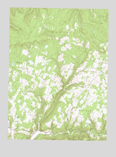
Overton, PA USGS Topographic Map
Click on map above to begin viewing in our Map Viewer.

This topographic map contains these locations and features:
Feature Name Type Latitude Longitude GNIS ID View Map
Bedford CornersLocaleN41.5434°W76.6030°1169083View Map
BethelPopulated PlaceN41.5537°W76.6074°1203076View Map
Big Bottom RunStreamN41.5079°W76.5494°1169483View Map
Blackwater RunStreamN41.5106°W76.6244°1192162View Map
Burgess PondReservoirN41.5715°W76.6190°1170711View Map
Cahill MountainSummitN41.5920°W76.6008°1170868View Map
CampbellvillePopulated PlaceN41.5481°W76.5538°1203216View Map
Collins HillSummitN41.5951°W76.5419°1172218View Map
Elkland SchoolSchoolN41.5556°W76.5691°1197360View Map
EstellaPopulated PlaceN41.5106°W76.6225°1174327View Map
Greenwood CemeteryCemeteryN41.5595°W76.5669°1176198View Map
Huckleberry MountainSummitN41.6109°W76.5058°1177543View Map
Hugos CornersLocaleN41.5667°W76.6069°1177571View Map
Kahill Fire TowerTowerN41.5917°W76.6013°1212950View Map
Kings CreekStreamN41.5109°W76.6244°1178490View Map
Lambert HillSummitN41.5259°W76.5386°1178823View Map
Level BranchStreamN41.5534°W76.5544°1179225View Map
Lick CreekStreamN41.5070°W76.5819°1179277View Map
Maple LakeReservoirN41.5201°W76.6142°1180352View Map
Maple Lake DamDamN41.5184°W76.6163°1195636View Map
Mill CreekStreamN41.5162°W76.5847°1181133View Map
MillviewPopulated PlaceN41.5062°W76.5913°1204186View Map
Millview CemeteryCemeteryN41.5070°W76.5749°1181287View Map
Molyneux HillSummitN41.5240°W76.5588°1181407View Map
OvertonPopulated PlaceN41.5701°W76.5030°1183142View Map
Pleasant ValleyValleyN41.5099°W76.5491°1184068View Map
Pleasant Valley SchoolSchoolN41.5240°W76.5499°1197362View Map
Rock RunStreamN41.5067°W76.5138°1185292View Map
Roscoe Burgess DamDamN41.5701°W76.6180°1195665View Map
Saint Francis Xavier Cemetery CemeteryCemeteryN41.5713°W76.5054°2776462View Map
Saint Pauls ChurchChurchN41.5740°W76.5011°1186631View Map
Saint Pauls United Church of Christ CemeteryCemeteryN41.5742°W76.5023°2776490View Map
Saint Peters ChurchChurchN41.5656°W76.6097°1186681View Map
Saints Phillip and James Church CemeteryCemeteryN41.5734°W76.5452°2776491View Map
Shrimp HillSummitN41.5167°W76.5211°1198300View Map
Streby RunStreamN41.5484°W76.5549°1188871View Map
Sugar RidgeRidgeN41.5623°W76.5497°1188958View Map
Sugar Ridge ChurchChurchN41.5731°W76.5444°1188960View Map
Township of ForksCivilN41.5024°W76.5522°1217071View Map
Township of OvertonCivilN41.6051°W76.5744°1215987View Map
Trout RunStreamN41.5106°W76.5166°1189855View Map
Vought CornersLocaleN41.5398°W76.5444°1212579View Map
Warburton HillSummitN41.5423°W76.5374°1190585View Map
Warburton Hill CemeteryCemeteryN41.5501°W76.5252°1190586View Map
Warburton Hill SchoolSchoolN41.5506°W76.5247°1197361View Map
Wright HillSummitN41.5206°W76.5338°1191801View Map
Yellow RunStreamN41.5076°W76.5044°1191882View Map

Note: Coordinates in the location and feature list above are referenced to NAD83 datum.


Copyright (C) 2008-2025 Ryan Niemi / Sunset Dynamics ... All Rights Reserved