TopoQuest Logo
Do you find TopoQuest useful?
Help keep TopoQuest running and adding new maps/features by donating!
Bitcoin:  19c7KJd3qBynnjoSw5npx9KScwjBe4ifkT
Litecoin:  LXs6TkuXGGXo1vDsWCkWVdjQX94eUKd6ui
Home View Maps Find Maps Find Places Resources & Links


Lone Hickory, North Carolina Topographic Map

USGS Map Title: Lone Hickory, NC
USGS Map MRC: 36080A6
DRG (GeoTIFF) Download: o36080a6.tif


Neighboring USGS Topographic Map Quads:


  Elkin South, NC  
36080B7
 

  Yadkinville, NC  
36080B6
 

  East Bend, NC  
36080B5
 

  Brooks Crossroads, NC  
36080A7
 

  Lone Hickory, NC  
36080A6
 

  Farmington, NC  
36080A5
 

  Harmony, NC  
35080H7
 

  Calahaln, NC  
35080H6
 

  Mocksville, NC  
35080H5


Map MRC Location:

N37°
W81°
N37°
W80°
H8 H7 H6 H5 H4 H3 H2 H1
G8 G7 G6 G5 G4 G3 G2 G1
F8 F7 F6 F5 F4 F3 F2 F1
E8 E7 E6 E5 E4 E3 E2 E1
D8 D7 D6 D5 D4 D3 D2 D1
C8 C7 C6 C5 C4 C3 C2 C1
B8 B7 B6 B5 B4 B3 B2 B1
A8 A7 A6 A5 A4 A3 A2 A1
N36°
W81°
N36°
W80°

Lone Hickory, NC USGS 1:24K Topographic Map Preview:
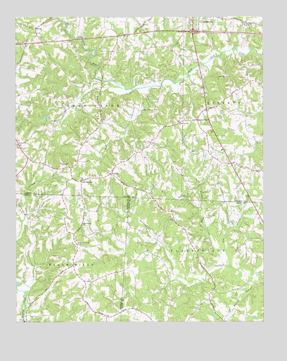
Lone Hickory, NC USGS Topographic Map
Click on map above to begin viewing in our Map Viewer.

This topographic map contains these locations and features:
Feature Name Type Latitude Longitude GNIS ID View Map
Bethel Baptist ChurchChurchN36.0821°W80.7062°981161View Map
Bethel CemeteryCemeteryN36.0812°W80.7065°1731712View Map
Big Kennedy CreekStreamN36.0168°W80.7498°1001705View Map
Brandons Friends CemeteryCemeteryN36.1190°W80.7392°1731718View Map
BranonPopulated PlaceN36.1207°W80.7395°981833View Map
Branon Friends ChurchChurchN36.1187°W80.7395°1731802View Map
Cain Mill BranchStreamN36.0432°W80.6553°982404View Map
Clarksville Pentecostal HolinessChurchN36.0074°W80.6512°1008048View Map
Clarksville Post OfficePost OfficeN36.0071°W80.6517°1008046View Map
Cooks School (historical)SchoolN36.0354°W80.6781°1805891View Map
Double Oak School (historical)SchoolN36.0815°W80.6578°1731808View Map
Dry BranchStreamN36.0221°W80.6401°984355View Map
Dutchman Creek W/S Number FiveReservoirN36.0135°W80.6315°999907View Map
Dutchman Creek W/S Number TwoReservoirN36.0435°W80.6548°999968View Map
Dutchman Creek W/S Structure Number Five DamDamN36.0135°W80.6315°999908View Map
Dutchman Creek W/S Structure Number Two DamDamN36.0435°W80.6548°999967View Map
Felix Post OfficePost OfficeN36.0174°W80.6501°1008047View Map
Fisher CreekStreamN36.0960°W80.6859°985101View Map
FootvillePopulated PlaceN36.0607°W80.7020°1006206View Map
Gospel Way Baptist ChurchChurchN36.1004°W80.6431°985867View Map
Gospel Way CemeteryCemeteryN36.1001°W80.6434°1731740View Map
Hanes Grove CemeteryCemeteryN36.0726°W80.7492°1731742View Map
Hanes Grove Methodist ChurchChurchN36.0729°W80.7487°986354View Map
Haubers Mill (historical)LocaleN36.1096°W80.6584°1731820View Map
Howard BranchStreamN36.0001°W80.6440°987177View Map
James Dobbins LakeReservoirN36.0751°W80.6948°1000022View Map
James Dobbins Lake DamDamN36.0751°W80.6948°1000021View Map
Joyner Community CenterLocaleN36.0321°W80.7187°987796View Map
Joyner School (historical)SchoolN36.0321°W80.7190°1805895View Map
Kennedy CreekStreamN36.0165°W80.7490°987920View Map
Leslie Chamberlain LakeReservoirN36.0918°W80.7198°1000061View Map
Leslie Chamberlain Lake DamDamN36.0918°W80.7198°1000060View Map
Liberty Baptist ChurchChurchN36.0426°W80.6706°988418View Map
Lone HickoryPopulated PlaceN36.0579°W80.7170°988869View Map
Lone Hickory AirportAirportN36.0608°W80.6898°2679286View Map
Lone Hickory TabernacleChurchN36.0640°W80.7234°988870View Map
Lone Hickory Volunteer Fire DepartmentBuildingN36.0608°W80.7215°2638381View Map
Martins StoreLocaleN36.0832°W80.6578°989410View Map
Piney Ridge AirportAirportN36.0661°W80.6997°2679285View Map
Prison Unit Number 068LocaleN36.1221°W80.6340°1023683View Map
Sandy Springs Baptist ChurchChurchN36.0404°W80.7159°994333View Map
Sandy Springs CemeteryCemeteryN36.0412°W80.7156°1731705View Map
South Oak Ridge Baptist ChurchChurchN36.0821°W80.6673°995182View Map
South Oak Ridge CemeteryCemeteryN36.0815°W80.6684°1731787View Map
Steelman CreekStreamN36.0232°W80.6442°995450View Map
Thad Carlton LakeReservoirN36.1168°W80.6731°1000113View Map
Thad Carlton Lake DamDamN36.1168°W80.6731°1000112View Map
Todd PondReservoirN36.0785°W80.6431°1000027View Map
Todd Pond DamDamN36.0785°W80.6431°1000028View Map
Township of ClarksvilleCivilN36.0008°W80.6357°1026633View Map
Township of Deep CreekCivilN36.1047°W80.7249°1027354View Map
Vestal Mill (historical)LocaleN36.1171°W80.7187°1731839View Map
Vestal School (historical)SchoolN36.0737°W80.7131°1731840View Map
William Arnold LakeReservoirN36.0885°W80.7281°1000052View Map
William Arnold Lake DamDamN36.0885°W80.7281°1000051View Map
Yadkin County Home (historical)LocaleN36.1162°W80.6312°1731842View Map
Yadkin Recreation Park LakeReservoirN36.1151°W80.6381°1000109View Map
Yadkin Recreation Park Lake DamDamN36.1151°W80.6381°1000108View Map

Note: Coordinates in the location and feature list above are referenced to NAD83 datum.


Copyright (C) 2008-2024 Ryan Niemi / Sunset Dynamics ... All Rights Reserved