TopoQuest Logo
Do you find TopoQuest useful?
Help keep TopoQuest running and adding new maps/features by donating!
Bitcoin:  19c7KJd3qBynnjoSw5npx9KScwjBe4ifkT
Litecoin:  LXs6TkuXGGXo1vDsWCkWVdjQX94eUKd6ui
Home View Maps Find Maps Find Places Resources & Links


East Brady, Pennsylvania Topographic Map

USGS Map Title: East Brady, PA
USGS Map MRC: 40079H5
DRG (GeoTIFF) Download: o40079h5.tif


Neighboring USGS Topographic Map Quads:


  Parker, PA  
41079A6
 

  Rimersburg, PA  
41079A5
 

  Sligo, PA  
41079A4
 

  Chicora, PA  
40079H6
 

  East Brady, PA  
40079H5
 

  Templeton, PA  
40079H4
 

  Worthington, PA  
40079G6
 

  Kittanning, PA  
40079G5
 

  Mosgrove, PA  
40079G4


Map MRC Location:

N41°
W80°
N41°
W79°
H8 H7 H6 H5 H4 H3 H2 H1
G8 G7 G6 G5 G4 G3 G2 G1
F8 F7 F6 F5 F4 F3 F2 F1
E8 E7 E6 E5 E4 E3 E2 E1
D8 D7 D6 D5 D4 D3 D2 D1
C8 C7 C6 C5 C4 C3 C2 C1
B8 B7 B6 B5 B4 B3 B2 B1
A8 A7 A6 A5 A4 A3 A2 A1
N40°
W80°
N40°
W79°

East Brady, PA USGS 1:24K Topographic Map Preview:
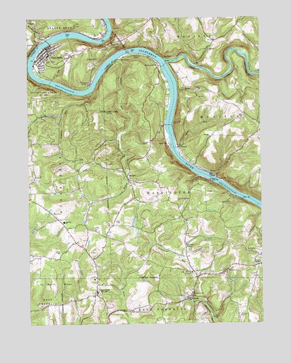
East Brady, PA USGS Topographic Map
Click on map above to begin viewing in our Map Viewer.

This topographic map contains these locations and features:
Feature Name Type Latitude Longitude GNIS ID View Map
AdrianPopulated PlaceN40.8848°W79.5378°1168083View Map
Adrian Post OfficePost OfficeN40.8851°W79.5419°2772567View Map
Allegheny River Lock and Dam NineDamN40.9551°W79.5481°1195177View Map
Allegheny River Pool NineReservoirN40.9551°W79.5481°1195176View Map
Borough of East BradyCivilN40.9836°W79.6132°1215083View Map
Bowser CemeteryCemeteryN40.9184°W79.5341°2775882View Map
Bradys BendBendN40.9956°W79.6217°1170143View Map
Bradys Bend Iron Furnaces Historical SiteParkN40.9992°W79.6239°1212191View Map
Brush Valley CemeteryCemeteryN40.9045°W79.5065°2775885View Map
Brush Valley ChurchChurchN40.9040°W79.5053°1170469View Map
Burnt RidgeRidgeN40.8928°W79.6045°1170750View Map
Church CampLocaleN40.9226°W79.6162°1171848View Map
CosmusPopulated PlaceN40.9462°W79.5425°1203346View Map
Cowan StationLocaleN40.8942°W79.5831°1212192View Map
CowansvillePopulated PlaceN40.8878°W79.5884°1213572View Map
Cowansville CemeteryCemeteryN40.8878°W79.5871°2775896View Map
Cowansville Post OfficePost OfficeN40.8879°W79.5888°2772651View Map
Crissman Family CemeteryCemeteryN40.8878°W79.5403°2775890View Map
Croyle CemeteryCemeteryN40.8784°W79.5106°1172783View Map
East BradyPopulated PlaceN40.9859°W79.6131°1173727View Map
East Brady Area Ambulance ServiceBuildingN40.9871°W79.6166°2719551View Map
East Brady Elementary SchoolSchoolN40.9851°W79.6131°1205210View Map
East Brady Junior-Senior High SchoolSchoolN40.9851°W79.6137°1211524View Map
East Brady Post OfficePost OfficeN40.9873°W79.6163°2772680View Map
East Brady Volunteer Fire Department Station 530BuildingN40.9822°W79.6155°2644777View Map
Fair CemeteryCemeteryN40.8961°W79.5667°2775911View Map
Frenchs CornersPopulated PlaceN40.8990°W79.5014°1175230View Map
Huling RunStreamN40.9837°W79.5756°1177575View Map
Limestone ChurchChurchN40.8970°W79.5178°1179356View Map
Limestone Church of God CemeteryCemeteryN40.8973°W79.5174°2775926View Map
Mast RunStreamN40.9470°W79.5442°1180537View Map
Montgomeryville Baptist Church CemeteryCemeteryN40.8872°W79.5374°2775937View Map
Montgomeryville ChurchChurchN40.8867°W79.5375°1181467View Map
Montgomeryville StationLocaleN40.8859°W79.5370°1212193View Map
Morrows CornerPopulated PlaceN40.9078°W79.5406°1204210View Map
Offutt Acres AirportAirportN40.9856°W79.5685°1194151View Map
Peach HillSummitN40.9328°W79.5489°1201520View Map
PhillipstonPopulated PlaceN40.9742°W79.5903°1200109View Map
Red Bank StationLocaleN40.9834°W79.5509°1213584View Map
Redbank CreekStreamN40.9820°W79.5500°1190990View Map
Redbank FurnaceLocaleN40.9831°W79.5481°1205211View Map
Reynolds CemeteryCemeteryN40.9790°W79.5459°2775956View Map
Rich Hill United Presbyterian Church CemeteryCemeteryN40.8920°W79.5892°2775957View Map
RimerPopulated PlaceN40.9362°W79.5253°1185087View Map
RiverviewPopulated PlaceN40.9898°W79.5737°1204519View Map
Saint Eusebius CemeteryCemeteryN40.9861°W79.5998°1185933View Map
Saint Marks ChurchChurchN40.8959°W79.5373°1186333View Map
Saint Marks Lutheran Church CemeteryCemeteryN40.8959°W79.5370°2775966View Map
Saint Marys ChurchChurchN40.9720°W79.5392°1186419View Map
Saint Marys Episcopal CemeteryCemeteryN40.9718°W79.5400°2775954View Map
ShannonLocaleN40.9803°W79.5045°1205212View Map
Sherrat Post Office (historical)Post OfficeN40.9348°W79.5712°1214453View Map
SherrettPopulated PlaceN40.9348°W79.5712°1187495View Map
Sherrett CemeteryCemeteryN40.9330°W79.5551°2775975View Map
Simpson / Templeton CemeteryCemeteryN40.9093°W79.5941°2775976View Map
Snyder Ranch HeliportAirportN40.8865°W79.5900°1213792View Map
Snyders RunStreamN40.9701°W79.5895°1187965View Map
Sugar CreekStreamN40.9920°W79.6137°1188930View Map
Sugarcreek Elementary SchoolSchoolN40.9167°W79.6062°1211523View Map
TempletonLocaleN40.9042°W79.5925°1213474View Map
Township of BradyCivilN40.9822°W79.5927°1216202View Map
Township of WashingtonCivilN40.9270°W79.5371°1215863View Map
Van BurenPopulated PlaceN40.9834°W79.5739°1204864View Map
Washington Township Memorial ParkParkN40.9256°W79.5467°1213475View Map
Washington Township Volunteer Fire Department Station 280BuildingN40.8983°W79.5026°2644844View Map
WattersonvillePopulated PlaceN40.9812°W79.5539°1190698View Map
Wattersonville United Methodist CemeteryCemeteryN40.9804°W79.5536°2775988View Map
Whiskey RunStreamN40.9992°W79.6245°1209285View Map

Note: Coordinates in the location and feature list above are referenced to NAD83 datum.


Copyright (C) 2008-2024 Ryan Niemi / Sunset Dynamics ... All Rights Reserved