TopoQuest Logo
Do you find TopoQuest useful?
Help keep TopoQuest running and adding new maps/features by donating!
Bitcoin:  19c7KJd3qBynnjoSw5npx9KScwjBe4ifkT
Litecoin:  LXs6TkuXGGXo1vDsWCkWVdjQX94eUKd6ui
Home View Maps Find Maps Find Places Resources & Links


Chicora, Pennsylvania Topographic Map

USGS Map Title: Chicora, PA
USGS Map MRC: 40079H6
DRG (GeoTIFF) Download: o40079h6.tif


Neighboring USGS Topographic Map Quads:


  Hilliards, PA  
41079A7
 

  Parker, PA  
41079A6
 

  Rimersburg, PA  
41079A5
 

  East Butler, PA  
40079H7
 

  Chicora, PA  
40079H6
 

  East Brady, PA  
40079H5
 

  Saxonburg, PA  
40079G7
 

  Worthington, PA  
40079G6
 

  Kittanning, PA  
40079G5


Map MRC Location:

N41°
W80°
N41°
W79°
H8 H7 H6 H5 H4 H3 H2 H1
G8 G7 G6 G5 G4 G3 G2 G1
F8 F7 F6 F5 F4 F3 F2 F1
E8 E7 E6 E5 E4 E3 E2 E1
D8 D7 D6 D5 D4 D3 D2 D1
C8 C7 C6 C5 C4 C3 C2 C1
B8 B7 B6 B5 B4 B3 B2 B1
A8 A7 A6 A5 A4 A3 A2 A1
N40°
W80°
N40°
W79°

Chicora, PA USGS 1:24K Topographic Map Preview:
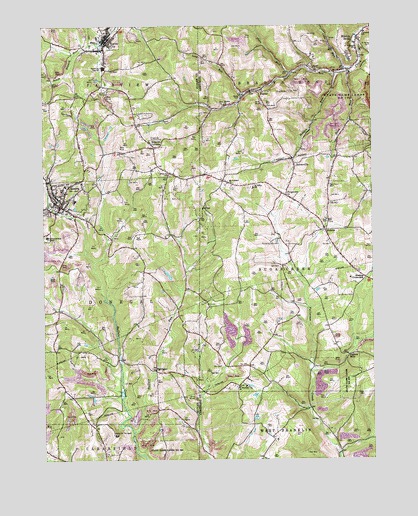
Chicora, PA USGS Topographic Map
Click on map above to begin viewing in our Map Viewer.

This topographic map contains these locations and features:
Feature Name Type Latitude Longitude GNIS ID View Map
AdamsPopulated PlaceN40.9412°W79.6423°1202948View Map
Adams Post Office (historical)Post OfficeN40.9412°W79.6423°1214454View Map
Berean ChurchChurchN40.9773°W79.6795°1169288View Map
Borough of ChicoraCivilN40.9505°W79.7402°1214988View Map
Borough of Karns CityCivilN40.9970°W79.7264°1214996View Map
Bradys BendPopulated PlaceN40.9965°W79.6295°1170144View Map
Bradys Bend CemeteryCemeteryN40.9906°W79.6333°2775883View Map
Bradys Bend Township SchoolSchoolN40.9978°W79.6273°1209234View Map
Browns CrossroadsPopulated PlaceN40.9273°W79.6273°1203169View Map
Buffalo RunStreamN40.8831°W79.7159°1170616View Map
ChicoraPopulated PlaceN40.9481°W79.7428°1171775View Map
Chicora Community Independent Hose Company Station 26BuildingN40.9493°W79.7456°2645726View Map
Chicora Elementary SchoolSchoolN40.9495°W79.7373°1205169View Map
Chicora Medical CenterHospitalN40.9392°W79.7484°1212446View Map
Chicora Post OfficePost OfficeN40.9488°W79.7452°2772633View Map
Cove RunStreamN40.9876°W79.6342°1172531View Map
Fairmont StationLocaleN40.9817°W79.7370°1212897View Map
Fosters MillsPopulated PlaceN40.9051°W79.6339°1203613View Map
FrogtownPopulated PlaceN40.9512°W79.6570°1175289View Map
GreenvillePopulated PlaceN40.9620°W79.6381°1202112View Map
Hart RunStreamN40.9878°W79.6325°1176599View Map
Holder RunStreamN40.9862°W79.6378°1177194View Map
Home for the AgedBuildingN40.8823°W79.7220°1209241View Map
Karns CityPopulated PlaceN40.9940°W79.7253°1178236View Map
Karns City High SchoolSchoolN40.9884°W79.7264°1205168View Map
Karns City Post OfficePost OfficeN40.9948°W79.7258°2772769View Map
KaylorPopulated PlaceN40.9812°W79.6678°1178259View Map
Kaylor BridgeBridgeN40.9759°W79.6856°1212448View Map
Kepples CornersPopulated PlaceN40.9651°W79.7070°1178397View Map
Liggett StationLocaleN40.9778°W79.7484°1212445View Map
Long RunStreamN40.9803°W79.6734°1212447View Map
MillerstownPopulated PlaceN40.9551°W79.7481°1201489View Map
Mount Pleasant ChurchChurchN40.9548°W79.6789°1181820View Map
Mount Pleasant Lutheran CemeteryCemeteryN40.9546°W79.6801°2775938View Map
Oak Grove / Saint Pauls United Church of Christ CemeteryCemeteryN40.9533°W79.6707°2775946View Map
Pine RunStreamN40.9862°W79.6542°1183897View Map
RattiganPopulated PlaceN40.9009°W79.7073°1184666View Map
Ridgeview Country ClubLocaleN40.9673°W79.7081°1213343View Map
Saint Marys CemeteryCemeteryN40.9931°W79.6256°1186394View Map
Saint Patricks CemeteryCemeteryN40.8966°W79.6779°2775969View Map
Saint Patricks ChurchChurchN40.8962°W79.6764°1186536View Map
Saint Patricks ChurchChurchN40.9931°W79.6303°1186537View Map
Saint Pauls ChurchChurchN40.9534°W79.6695°1186621View Map
Saint Stephens Church (historical)ChurchN40.9965°W79.6317°1212896View Map
SomervillePopulated PlaceN40.9606°W79.6539°1187996View Map
State Game Lands Number 105ParkN40.9784°W79.6289°1188430View Map
State Game Lands Number 259ParkN40.9084°W79.6331°1208336View Map
State Game Lands Number 304ParkN40.8762°W79.7042°1209264View Map
Sugarcreek Township Ambulance Service Station 230BuildingN40.9516°W79.6580°2719498View Map
Sugarcreek Township Volunteer Fire Department Station 230BuildingN40.9405°W79.6410°2644907View Map
Township of Bradys BendCivilN40.9842°W79.6479°1217462View Map
Township of DonegalCivilN40.9204°W79.7369°1216053View Map
Township of FairviewCivilN40.9922°W79.7379°1216054View Map
Township of SugarcreekCivilN40.9285°W79.6355°1215861View Map
Trinity ChurchChurchN40.9906°W79.6292°1189801View Map
Waltman AirportAirportN40.9274°W79.7392°1194137View Map
White Oak CemeteryCemeteryN40.9573°W79.7014°1191295View Map

Note: Coordinates in the location and feature list above are referenced to NAD83 datum.


Copyright (C) 2008-2025 Ryan Niemi / Sunset Dynamics ... All Rights Reserved