TopoQuest Logo
Do you find TopoQuest useful?
Help keep TopoQuest running and adding new maps/features by donating!
Bitcoin:  19c7KJd3qBynnjoSw5npx9KScwjBe4ifkT
Litecoin:  LXs6TkuXGGXo1vDsWCkWVdjQX94eUKd6ui
Home View Maps Find Maps Find Places Resources & Links


East Fork, Kentucky Topographic Map

USGS Map Title: East Fork, KY
USGS Map MRC: 37085A5
DRG (GeoTIFF) Download: o37085a5.tif


Neighboring USGS Topographic Map Quads:


  Center, KY  
37085B6
 

  Exie, KY  
37085B5
 

  Gresham, KY  
37085B4
 

  Sulphur Well, KY  
37085A6
 

  East Fork, KY  
37085A5
 

  Gradyville, KY  
37085A4
 

  Summer Shade, KY  
36085H6
 

  Edmonton, KY  
36085H5
 

  Breeding, KY  
36085H4


Map MRC Location:

N38°
W86°
N38°
W85°
H8 H7 H6 H5 H4 H3 H2 H1
G8 G7 G6 G5 G4 G3 G2 G1
F8 F7 F6 F5 F4 F3 F2 F1
E8 E7 E6 E5 E4 E3 E2 E1
D8 D7 D6 D5 D4 D3 D2 D1
C8 C7 C6 C5 C4 C3 C2 C1
B8 B7 B6 B5 B4 B3 B2 B1
A8 A7 A6 A5 A4 A3 A2 A1
N37°
W86°
N37°
W85°

East Fork, KY USGS 1:24K Topographic Map Preview:
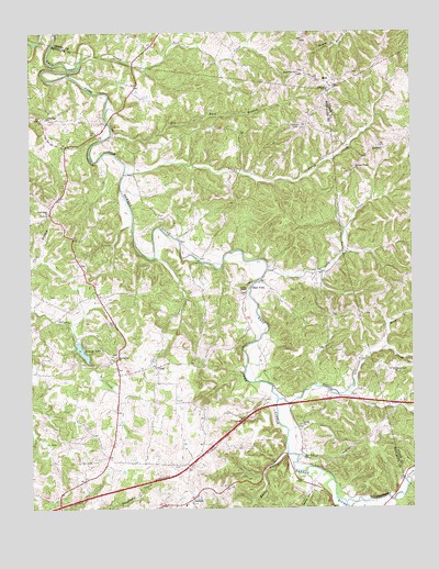
East Fork, KY USGS Topographic Map
Click on map above to begin viewing in our Map Viewer.

This topographic map contains these locations and features:
Feature Name Type Latitude Longitude GNIS ID View Map
Adams CreekStreamN37.0889°W85.5927°485771View Map
Bennett RidgeRidgeN37.0746°W85.5082°2743179View Map
Butler BranchStreamN37.0145°W85.5411°488504View Map
Caney Fork CreekStreamN37.1173°W85.6069°488869View Map
Cedar Top ChurchChurchN37.1028°W85.6189°489251View Map
CorkPopulated PlaceN37.0376°W85.5833°507761View Map
County LakeReservoirN37.0415°W85.6084°490159View Map
Dry Fork BranchStreamN37.0995°W85.5972°491210View Map
East ForkLocaleN37.0589°W85.5511°491433View Map
East Fork ChurchChurchN37.0131°W85.5352°491445View Map
Foundation ChurchChurchN37.0398°W85.5969°492372View Map
GasconPopulated PlaceN37.0037°W85.5711°508073View Map
KeltnerPopulated PlaceN37.0951°W85.5102°508376View Map
Lawrence CreekStreamN37.0309°W85.5211°496077View Map
Leatherwood CreekStreamN37.0020°W85.5216°496125View Map
Lick BranchStreamN37.0091°W85.5496°2742634View Map
Long CreekStreamN37.0626°W85.5464°497093View Map
Maple Hill ChurchChurchN37.1139°W85.5358°497511View Map
MellPopulated PlaceN37.1123°W85.5286°508587View Map
Moss BranchStreamN37.0426°W85.5083°498665View Map
Penick ChurchChurchN37.0220°W85.5364°500375View Map
Pink Ridge ChurchChurchN37.0776°W85.6194°500738View Map
Pleasant Ridge United Methodist ChurchChurchN37.0890°W85.5185°500893View Map
Prices CreekStreamN37.0289°W85.5439°501326View Map
Prices Creek (historical)Populated PlaceN37.0365°W85.5062°2743403View Map
Prices Creek ChurchChurchN37.0362°W85.5061°501327View Map
Society Hill ChurchChurchN37.0003°W85.5722°503866View Map
Sparks HollowValleyN37.0042°W85.5339°504030View Map
Union ChapelChurchN37.0570°W85.5552°505769View Map
WKNK-FM (Edmonton)TowerN37.0259°W85.5539°517940View Map

Note: Coordinates in the location and feature list above are referenced to NAD83 datum.


Copyright (C) 2008-2025 Ryan Niemi / Sunset Dynamics ... All Rights Reserved