TopoQuest Logo
Do you find TopoQuest useful?
Help keep TopoQuest running and adding new maps/features by donating!
Bitcoin:  19c7KJd3qBynnjoSw5npx9KScwjBe4ifkT
Litecoin:  LXs6TkuXGGXo1vDsWCkWVdjQX94eUKd6ui
Home View Maps Find Maps Find Places Resources & Links


Summer Shade, Kentucky Topographic Map

USGS Map Title: Summer Shade, KY
USGS Map MRC: 36085H6
DRG (GeoTIFF) Download: o36085h6.tif


Neighboring USGS Topographic Map Quads:


  Hiseville, KY  
37085A7
 

  Sulphur Well, KY  
37085A6
 

  East Fork, KY  
37085A5
 

  Temple Hill, KY  
36085H7
 

  Summer Shade, KY  
36085H6
 

  Edmonton, KY  
36085H5
 

  Freedom, KY  
36085G7
 

  Sulphur Lick, KY  
36085G6
 

  Dubre, KY  
36085G5


Map MRC Location:

N37°
W86°
N37°
W85°
H8 H7 H6 H5 H4 H3 H2 H1
G8 G7 G6 G5 G4 G3 G2 G1
F8 F7 F6 F5 F4 F3 F2 F1
E8 E7 E6 E5 E4 E3 E2 E1
D8 D7 D6 D5 D4 D3 D2 D1
C8 C7 C6 C5 C4 C3 C2 C1
B8 B7 B6 B5 B4 B3 B2 B1
A8 A7 A6 A5 A4 A3 A2 A1
N36°
W86°
N36°
W85°

Summer Shade, KY USGS 1:24K Topographic Map Preview:
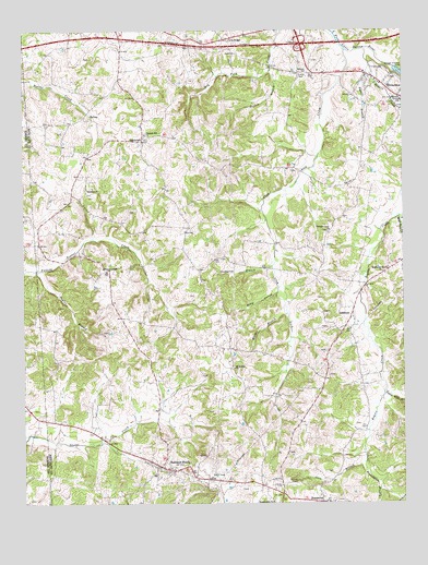
Summer Shade, KY USGS Topographic Map
Click on map above to begin viewing in our Map Viewer.

This topographic map contains these locations and features:
Feature Name Type Latitude Longitude GNIS ID View Map
BeaumontPopulated PlaceN36.8756°W85.6519°486599View Map
Bellview ChurchChurchN36.9895°W85.6566°486827View Map
Black Rock CreekStreamN36.9512°W85.6261°487384View Map
Branstetter BranchStreamN36.8887°W85.6377°487836View Map
Cave BranchStreamN36.8862°W85.6377°489110View Map
Cave RidgeLocaleN36.9981°W85.6827°489128View Map
Clay Lick CreekStreamN36.9951°W85.6439°489582View Map
Duggar BranchStreamN36.9892°W85.6347°491268View Map
Edmonton Volunteer Fire and RescueBuildingN36.9886°W85.6370°2637346View Map
GoodluckPopulated PlaceN36.9253°W85.6416°508112View Map
Graven HillSummitN36.8775°W85.6668°2742632View Map
Hardin BranchStreamN36.9901°W85.6683°493719View Map
Hickory College ChurchChurchN36.9370°W85.7225°494121View Map
Metcalfe CountyCivilN36.9905°W85.6293°516931View Map
Metcalfe County Fire DepartmentBuildingN36.9896°W85.6386°2636996View Map
Miner HollowValleyN36.9308°W85.6666°498401View Map
Missionary Mound ChurchChurchN36.9364°W85.6316°498437View Map
Mount Moriah ChurchChurchN36.9112°W85.6811°498775View Map
Pleasant Grove ChurchChurchN36.9473°W85.6491°500814View Map
Pleasant Hill Church of ChristChurchN36.9724°W85.7097°500855View Map
RandolphPopulated PlaceN36.9709°W85.7105°508899View Map
Randolph ChurchChurchN36.9584°W85.7291°501568View Map
Rogers CreekStreamN36.9948°W85.6377°502278View Map
Sulfur Well BranchStreamN36.9051°W85.6314°504717View Map
Summer ShadePopulated PlaceN36.8842°W85.7025°504782View Map
Summer Shade Census Designated PlaceCensusN36.8836°W85.7098°2629686View Map
Summer Shade DivisionCivilN36.9181°W85.6861°1937281View Map
Summer Shade Fire DepartmentBuildingN36.8840°W85.7054°2636414View Map
Taylor BranchStreamN36.9370°W85.7455°504986View Map
Thompson BranchStreamN36.9378°W85.6680°505181View Map
Worder BranchStreamN36.9256°W85.6636°507144View Map

Note: Coordinates in the location and feature list above are referenced to NAD83 datum.


Copyright (C) 2008-2024 Ryan Niemi / Sunset Dynamics ... All Rights Reserved