TopoQuest Logo
Do you find TopoQuest useful?
Help keep TopoQuest running and adding new maps/features by donating!
Bitcoin:  19c7KJd3qBynnjoSw5npx9KScwjBe4ifkT
Litecoin:  LXs6TkuXGGXo1vDsWCkWVdjQX94eUKd6ui
Home View Maps Find Maps Find Places Resources & Links


East Troy, Wisconsin Topographic Map

USGS Map Title: East Troy, WI
USGS Map MRC: 42088G4
DRG (GeoTIFF) Download: o42088g4.tif


Neighboring USGS Topographic Map Quads:


  Palmyra, WI  
42088H5
 

  Eagle, WI  
42088H4
 

  Genesee, WI  
42088H3
 

  Little Prairie, WI  
42088G5
 

  East Troy, WI  
42088G4
 

  Mukwonago, WI  
42088G3
 

  Elkhorn, WI  
42088F5
 

  Springfield, WI  
42088F4
 

  Burlington, WI  
42088F3


Map MRC Location:

N43°
W89°
N43°
W88°
H8 H7 H6 H5 H4 H3 H2 H1
G8 G7 G6 G5 G4 G3 G2 G1
F8 F7 F6 F5 F4 F3 F2 F1
E8 E7 E6 E5 E4 E3 E2 E1
D8 D7 D6 D5 D4 D3 D2 D1
C8 C7 C6 C5 C4 C3 C2 C1
B8 B7 B6 B5 B4 B3 B2 B1
A8 A7 A6 A5 A4 A3 A2 A1
N42°
W89°
N42°
W88°

East Troy, WI USGS 1:24K Topographic Map Preview:
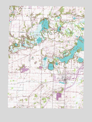
East Troy, WI USGS Topographic Map
Click on map above to begin viewing in our Map Viewer.

This topographic map contains these locations and features:
Feature Name Type Latitude Longitude GNIS ID View Map
2 ReservoirReservoirN42.8379°W88.4952°1792480View Map
2 ReservoirReservoirN42.8367°W88.4834°1793361View Map
Army LakeLakeN42.8098°W88.3806°1560949View Map
Army Lake (historical)Populated PlaceN42.8067°W88.3754°1851216View Map
Beulah Bog State Natural AreaParkN42.8028°W88.4082°1988794View Map
Beulah IslandIslandN42.8331°W88.3812°1851219View Map
Booth LakeLakeN42.8009°W88.4296°1562074View Map
Broad BayBayN42.8231°W88.3765°1851223View Map
Brooks BayBayN42.8339°W88.3845°1851224View Map
Brown LakeLakeN42.8611°W88.4183°2764590View Map
Camp ChesterLocaleN42.8061°W88.4304°1562590View Map
Camp EdwardsLocaleN42.8206°W88.3859°1562601View Map
Chester Byrnes Elementary SchoolSchoolN42.7875°W88.4066°2716675View Map
Divine Word SeminarySchoolN42.8131°W88.3920°1564005View Map
Doubek Elementary SchoolSchoolN42.7872°W88.4092°2716373View Map
Eagle Centre Prairie State Natural AreaParkN42.8720°W88.4807°2054641View Map
Eagle Spring LakeReservoirN42.8518°W88.4412°1792287View Map
EaglevillePopulated PlaceN42.8547°W88.4329°1564265View Map
Eagleville Charter SchoolSchoolN42.8590°W88.4338°2716352View Map
Eagleville Mills (historical)BuildingN42.8531°W88.4344°2761357View Map
East TroyPopulated PlaceN42.7853°W88.4051°1564382View Map
East Troy Emergency ServicesBuildingN42.7957°W88.3853°2698037View Map
East Troy High SchoolSchoolN42.7875°W88.4174°1851245View Map
East Troy Middle SchoolSchoolN42.7860°W88.4183°1851246View Map
East Troy Municipal AirportAirportN42.7979°W88.3783°1581954View Map
East Troy Police DepartmentBuildingN42.7881°W88.3911°2759689View Map
East Troy PondLakeN42.7814°W88.4107°2764438View Map
Evergreen CemeteryCemeteryN42.7925°W88.4690°1564740View Map
Fairy IslandIslandN42.8017°W88.4284°1851252View Map
First Congregational ChurchChurchN42.7858°W88.4073°2003878View Map
Good Shepherd Lutheran SchoolSchoolN42.7907°W88.4222°2716388View Map
Hateleys BayBayN42.8070°W88.4048°1851281View Map
Hogan LakeLakeN42.8511°W88.4146°2764598View Map
House of the Lord Christian ChurchChurchN42.7839°W88.4051°2003879View Map
Jericho CemeteryCemeteryN42.8739°W88.4234°1567157View Map
Jericho CreekStreamN42.8566°W88.4339°1567158View Map
Kettle Moraine Estates 3WR1719 DamDamN42.8383°W88.4951°1792479View Map
Kettle Morraine Estates Corporation 3WR1719 DamDamN42.8367°W88.4834°1793360View Map
Kroll OutletStreamN42.8539°W88.4328°2761356View Map
Lake BeulahReservoirN42.8220°W88.3886°1561664View Map
Lake Beulah DamDamN42.8383°W88.3823°1792881View Map
Lulu LakeLakeN42.8331°W88.4497°1568801View Map
Lulu Lake State Natural AreaParkN42.8361°W88.4529°1988797View Map
Mayhews (historical)Populated PlaceN42.7631°W88.4901°1851299View Map
Mill LakeLakeN42.8356°W88.3801°1851302View Map
Mukwonago ParkParkN42.8628°W88.3882°1570018View Map
Mukwonago Park PondLakeN42.8618°W88.3944°2764599View Map
Oak Grove CemeteryCemeteryN42.8650°W88.4873°1570610View Map
Oak Knoll CemeteryCemeteryN42.8742°W88.4795°1570655View Map
Oak Ridge CemeteryCemeteryN42.7928°W88.3917°1570679View Map
Oak Ridge CemeteryCemeteryN42.8739°W88.4820°1570681View Map
Pabst DamDamN42.8283°W88.4868°1792883View Map
Pabst Lake 5ReservoirN42.8272°W88.4877°1792884View Map
Paratech Ambulance Service East TroyBuildingN42.7956°W88.3852°2698408View Map
Pickerel LakeLakeN42.8106°W88.4391°1571314View Map
Pickerel Lake Fen State Natural AreaParkN42.8011°W88.4418°1988798View Map
Prairie View Elementary SchoolSchoolN42.7841°W88.4267°2716562View Map
Rainbow Springs LakeLakeN42.8459°W88.4176°1572046View Map
Roxy PondLakeN42.8606°W88.3917°2764658View Map
Ruskin LakeLakeN42.8343°W88.4270°2764442View Map
Saint James United Methodist ChurchChurchN42.7845°W88.4082°2003882View Map
Saint Pauls Lutheran SchoolSchoolN42.7917°W88.3965°1851329View Map
Saint Peter Catholic ChurchChurchN42.7895°W88.4101°2003885View Map
Saint Peter Elementary SchoolSchoolN42.7897°W88.4110°1851330View Map
Saint Peters CemeteryCemeteryN42.8004°W88.3871°2002810View Map
Skyview TerracePopulated PlaceN42.7883°W88.4014°2508621View Map
Swan LakeLakeN42.8047°W88.4201°1575163View Map
Town of TroyCivilN42.7998°W88.4840°1584299View Map
TroyPopulated PlaceN42.7789°W88.4448°1575688View Map
Troy CenterPopulated PlaceN42.8097°W88.4651°1575689View Map
Troy Center Fire DepartmentBuildingN42.8138°W88.4655°2698148View Map
Troy Center United Methodist ChurchChurchN42.8111°W88.4665°2003883View Map
Troy Lakes CemeteryCemeteryN42.8311°W88.4120°1575690View Map
Twin IslandsIslandN42.8220°W88.3920°1851342View Map
Village of East TroyCivilN42.7848°W88.3972°1583119View Map
Wambold DamDamN42.8559°W88.4352°1792286View Map
Weldons PointCapeN42.8128°W88.4076°1851356View Map
West BayBayN42.8092°W88.4123°1851357View Map
Wilmers PointCapeN42.8083°W88.4070°1851370View Map
Wood LakeLakeN42.8480°W88.3778°1576966View Map

Note: Coordinates in the location and feature list above are referenced to NAD83 datum.


Copyright (C) 2008-2024 Ryan Niemi / Sunset Dynamics ... All Rights Reserved