TopoQuest Logo
Do you find TopoQuest useful?
Help keep TopoQuest running and adding new maps/features by donating!
Bitcoin:  19c7KJd3qBynnjoSw5npx9KScwjBe4ifkT
Litecoin:  LXs6TkuXGGXo1vDsWCkWVdjQX94eUKd6ui
Home View Maps Find Maps Find Places Resources & Links


Poinsett State Park, South Carolina Topographic Map

USGS Map Title: Poinsett State Park, SC
USGS Map MRC: 33080G5
DRG (GeoTIFF) Download: o33080g5.tif


Neighboring USGS Topographic Map Quads:


  Eastover, SC  
33080H6
 

  Wedgefield, SC  
33080H5
 

  Sumter West, SC  
33080H4
 

  Wateree, SC  
33080G6
 

  Poinsett State Park, SC  
33080G5
 

  Privateer, SC  
33080G4
 

  Fort Motte, SC  
33080F6
 

  Lone Star, SC  
33080F5
 

  Pinewood, SC  
33080F4


Map MRC Location:

N34°
W81°
N34°
W80°
H8 H7 H6 H5 H4 H3 H2 H1
G8 G7 G6 G5 G4 G3 G2 G1
F8 F7 F6 F5 F4 F3 F2 F1
E8 E7 E6 E5 E4 E3 E2 E1
D8 D7 D6 D5 D4 D3 D2 D1
C8 C7 C6 C5 C4 C3 C2 C1
B8 B7 B6 B5 B4 B3 B2 B1
A8 A7 A6 A5 A4 A3 A2 A1
N33°
W81°
N33°
W80°

Poinsett State Park, SC USGS 1:24K Topographic Map Preview:
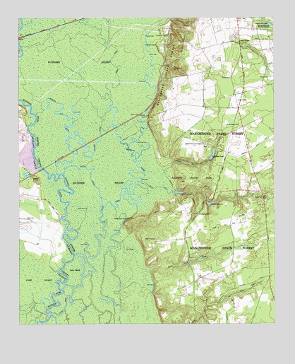
Poinsett State Park, SC USGS Topographic Map
Click on map above to begin viewing in our Map Viewer.

This topographic map contains these locations and features:
Feature Name Type Latitude Longitude GNIS ID View Map
Beech CreekStreamN33.7952°W80.5840°1220466View Map
Big LakeLakeN33.7874°W80.5759°1220715View Map
Bloom Hill CemeteryCemeteryN33.7840°W80.5631°1220809View Map
Bloom Hill School (historical)SchoolN33.7968°W80.5348°1244462View Map
Bloomhill Church (historical)ChurchN33.7968°W80.5351°1244463View Map
Brushtop LakeLakeN33.8240°W80.5668°1221041View Map
Burnt Gin LakeReservoirN33.8714°W80.5003°1221144View Map
Campbell CreekStreamN33.8121°W80.5537°1247128View Map
Campbell PondReservoirN33.8189°W80.5299°1221280View Map
Campbell Pond Dam D-1585DamN33.8168°W80.5309°1239371View Map
Christmas Mill LakeReservoirN33.7992°W80.5309°1221583View Map
Columbia Sumter Hunting ClubLocaleN33.7929°W80.5709°1247352View Map
Coulter CemeteryCemeteryN33.8410°W80.5173°1221771View Map
Deep HoleLakeN33.8096°W80.5651°1221981View Map
Dow LakeLakeN33.7639°W80.5594°1222083View Map
Drafts PondReservoirN33.8252°W80.5765°1237587View Map
Drafts Pond D-0601 DamDamN33.8252°W80.5765°1237586View Map
Elizabeth Church (historical)ChurchN33.7771°W80.5409°1244512View Map
Fork SwampSwampN33.7651°W80.6158°1222493View Map
Fullers Earth CreekStreamN33.7502°W80.5584°1222604View Map
Green LakeLakeN33.8357°W80.5968°1222874View Map
Gulledge PondReservoirN33.8667°W80.5195°1239339View Map
Gulledge Pond Dam D-1459DamN33.8668°W80.5215°1239338View Map
Halfway CreekStreamN33.8143°W80.5923°1222981View Map
Harvin School (historical)SchoolN33.7668°W80.5259°1244553View Map
Holly Hill LakeLakeN33.7977°W80.5912°1223237View Map
Joes IslandIslandN33.7713°W80.5976°1223582View Map
Kohlers Old RiverGutN33.8313°W80.6020°1223770View Map
Little RiverStreamN33.7544°W80.6086°2542484View Map
Manchester School (historical)SchoolN33.8246°W80.5220°1244592View Map
Manchester State ForestForestN33.8043°W80.5179°1224289View Map
Manchester State Forest HeadquartersLocaleN33.8232°W80.5340°1224290View Map
Melrose Historical HomeBuildingN33.8313°W80.5231°1224449View Map
Mount Sinai Church (historical)ChurchN33.7665°W80.5256°1244612View Map
Orange Hill ChurchChurchN33.8646°W80.5156°1249989View Map
Orange Hill SchoolSchoolN33.8643°W80.5151°1225242View Map
Orange Hill School (historical)SchoolN33.8646°W80.5159°1244627View Map
Poinsett Park LakeReservoirN33.8037°W80.5470°1239374View Map
Poinsett State ParkParkN33.8079°W80.5393°1225575View Map
Poisett State Park Lake Dam D-1589DamN33.8040°W80.5484°1239373View Map
Ramsey LakeLakeN33.8467°W80.5602°1225746View Map
Reese LakeLakeN33.8596°W80.5598°1225825View Map
Riverside Hunting CampLocaleN33.8640°W80.5568°1242462View Map
Rosemary Fire TowerTowerN33.8018°W80.5093°1242463View Map
Saint Augustine ChurchChurchN33.7952°W80.5373°1250499View Map
Sand RidgeIslandN33.7802°W80.5701°1226333View Map
Sandy CreekStreamN33.7952°W80.5840°1226360View Map
Shanks CreekStreamN33.8082°W80.5648°1226533View Map
Shoe LakeLakeN33.7814°W80.5916°1226593View Map
Starks Ferry (historical)CrossingN33.7938°W80.6040°1244706View Map
Sumter JunctionPopulated PlaceN33.8354°W80.5659°1231845View Map
Sumter Southwest DivisionCivilN33.7856°W80.5315°1938438View Map
Tank LakeLakeN33.8485°W80.5617°1227027View Map
Tiverton ChurchChurchN33.8504°W80.5209°1251179View Map
Walker and Walker Poultry FarmsLocaleN33.8325°W80.5433°2635193View Map
Wateree Electric PlantBuildingN33.8265°W80.6229°1249406View Map
WIBZ-FM (Wedgefield)TowerN33.8540°W80.5295°1252556View Map

Note: Coordinates in the location and feature list above are referenced to NAD83 datum.


Copyright (C) 2008-2024 Ryan Niemi / Sunset Dynamics ... All Rights Reserved