TopoQuest Logo
Do you find TopoQuest useful?
Help keep TopoQuest running and adding new maps/features by donating!
Bitcoin:  19c7KJd3qBynnjoSw5npx9KScwjBe4ifkT
Litecoin:  LXs6TkuXGGXo1vDsWCkWVdjQX94eUKd6ui
Home View Maps Find Maps Find Places Resources & Links


Eddyville, Kentucky Topographic Map

USGS Map Title: Eddyville, KY
USGS Map MRC: 37088A1
DRG (GeoTIFF) Download: o37088a1.tif


Neighboring USGS Topographic Map Quads:


  Dycusburg, KY  
37088B2
 

  Fredonia, KY  
37088B1
 

  Crider, KY  
37087B8
 

  Grand Rivers, KY  
37088A2
 

  Eddyville, KY  
37088A1
 

  Princeton West, KY  
37087A8
 

  Birmingham Point, KY  
36088H2
 

  Mont, KY  
36088H1
 

  Lamasco, KY  
36087H8


Map MRC Location:

N38°
W89°
N38°
W88°
H8 H7 H6 H5 H4 H3 H2 H1
G8 G7 G6 G5 G4 G3 G2 G1
F8 F7 F6 F5 F4 F3 F2 F1
E8 E7 E6 E5 E4 E3 E2 E1
D8 D7 D6 D5 D4 D3 D2 D1
C8 C7 C6 C5 C4 C3 C2 C1
B8 B7 B6 B5 B4 B3 B2 B1
A8 A7 A6 A5 A4 A3 A2 A1
N37°
W89°
N37°
W88°

Eddyville, KY USGS 1:24K Topographic Map Preview:
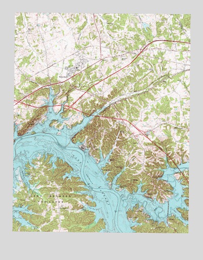
Eddyville, KY USGS Topographic Map
Click on map above to begin viewing in our Map Viewer.

This topographic map contains these locations and features:
Feature Name Type Latitude Longitude GNIS ID View Map
Barnet SpringSpringN37.0136°W88.0755°486389View Map
Bell HollowValleyN37.0396°W88.0158°486793View Map
Bell SpringSpringN37.0603°W88.0088°486798View Map
Bells CreekStreamN37.0137°W88.0106°486822View Map
Bonner CemeteryCemeteryN37.0150°W88.1181°487670View Map
Buena Vista EstatesPopulated PlaceN37.0251°W88.0478°507611View Map
Buzzard CreekStreamN37.0428°W88.0575°488530View Map
Cantrell SpringSpringN37.1196°W88.0599°488905View Map
CarmackPopulated PlaceN37.0181°W88.1159°507655View Map
Cash SpringSpringN37.1198°W88.0597°489058View Map
City of EddyvilleCivilN37.0759°W88.0770°2403538View Map
City of KuttawaCivilN37.0594°W88.1149°2404844View Map
Clay BayBayN37.0128°W88.0689°489566View Map
Crab Creek CemeteryCemeteryN37.0939°W88.0870°490241View Map
Cross RoadPopulated PlaceN37.0134°W88.0922°507786View Map
Crumbaugh SpringSpringN37.0927°W88.0264°490424View Map
Davenport BayBayN37.0312°W88.1181°490615View Map
Dixon CemeteryCemeteryN37.0142°W88.0911°490928View Map
Doctor George M Huggans Historical MarkerParkN37.0485°W88.0776°2744496View Map
Dycus CemeteryCemeteryN37.1239°W88.0078°491379View Map
Eddy BayPopulated PlaceN37.0084°W88.0114°507906View Map
Eddy CreekStreamN37.0203°W88.0486°491550View Map
Eddy Creek Recreational AreaParkN37.0039°W88.0197°491552View Map
EddyvillePopulated PlaceN37.0945°W88.0803°491553View Map
Eddyville CemeteryCemeteryN37.0473°W88.0678°491554View Map
Eddyville DivisionCivilN37.0905°W88.1213°1936983View Map
Eddyville Fire DepartmentBuildingN37.0909°W88.0846°2636770View Map
Eddyville Furnace Historical MarkerParkN37.0793°W88.1036°2744498View Map
Eddyville Police DepartmentBuildingN37.0938°W88.0885°2767604View Map
Eden BayPopulated PlaceN37.0301°W88.0403°507908View Map
Elm Grove ChurchChurchN37.0664°W88.1228°491729View Map
FairviewPopulated PlaceN37.0987°W88.0631°507972View Map
Glenns Chapel Methodist ChurchChurchN37.1148°W88.1142°492900View Map
GreenacresPopulated PlaceN37.0248°W88.0161°508127View Map
Gum SpringSpringN37.0862°W88.0197°493488View Map
Hammond CreekStreamN37.0739°W88.0886°493638View Map
Hawkins LakeReservoirN37.0573°W88.0286°493893View Map
Hildreth CemeteryCemeteryN37.0287°W88.1184°494240View Map
Hildreth CemeteryCemeteryN37.0328°W88.1145°494241View Map
Holiday Hills CampLocaleN37.0306°W88.0245°494389View Map
Indian HillsPopulated PlaceN37.0345°W88.0578°508309View Map
Kentucky State PenitentiaryBuildingN37.0488°W88.0758°2767749View Map
Knob CreekStreamN37.0795°W88.0986°495837View Map
Lady CemeteryCemeteryN37.0420°W88.0931°495903View Map
Lake CloughLakeN37.0550°W88.1243°2743556View Map
Last Skirmish of the Civil War Historical MarkerParkN37.0471°W88.0760°2744502View Map
Liberty ChurchChurchN37.0867°W88.0067°496369View Map
Lick CreekStreamN37.0684°W88.0667°496468View Map
Little Carmack CreekStreamN37.0128°W88.1184°496661View Map
Lyon CountyCivilN37.0191°W88.0833°516918View Map
Lyon County Ambulance ServiceBuildingN37.0913°W88.0865°2719151View Map
Lyon County Historical MarkerParkN37.0908°W88.0856°2744503View Map
Lyon County Sheriff's OfficeBuildingN37.0904°W88.0855°2767676View Map
Matthew Lyon Grave Historical MarkerParkN37.0461°W88.0692°2744504View Map
Mineral Mound Historical MarkerParkN37.0782°W88.0696°2744505View Map
Mount Pleasant ChurchChurchN37.0787°W88.1184°498837View Map
New Union Forge Historical MarkerParkN37.0579°W88.1131°2744506View Map
PalisadesPopulated PlaceN37.0217°W88.0272°508770View Map
Paradise HillsPopulated PlaceN37.0128°W88.0353°508775View Map
Perry SpringSpringN37.0576°W88.0492°500435View Map
Pleasant Hill ChurchChurchN37.0509°W88.0361°500859View Map
Providence CemeteryCemeteryN37.1006°W88.0497°501369View Map
Providence SpringSpringN37.0986°W88.0490°501384View Map
Roland SpringSpringN37.0025°W88.1102°502287View Map
Rolling Hills CemeteryCemeteryN37.1020°W88.0789°502300View Map
Silver CliffsCliffN37.0561°W88.1114°2743562View Map
Sky Pilot HarborLocaleN37.0409°W88.0572°503621View Map
Stoval SpringSpringN37.0323°W88.0193°504537View Map
Tinsley CreekStreamN37.0334°W88.0486°505294View Map
Tinsley Creek BayLocaleN37.0356°W88.0489°505296View Map
Tinsley HollowValleyN37.0372°W88.0450°505298View Map
Vista Ridge ParkParkN37.0642°W88.1109°506070View Map
Wildwood HillsPopulated PlaceN37.0089°W88.0397°509369View Map
Willow CreekStreamN37.0087°W88.1211°506863View Map
WWLK-AM (Eddyville)TowerN37.0739°W88.0800°517799View Map

Note: Coordinates in the location and feature list above are referenced to NAD83 datum.


Copyright (C) 2008-2024 Ryan Niemi / Sunset Dynamics ... All Rights Reserved