TopoQuest Logo
Do you find TopoQuest useful?
Help keep TopoQuest running and adding new maps/features by donating!
Bitcoin:  19c7KJd3qBynnjoSw5npx9KScwjBe4ifkT
Litecoin:  LXs6TkuXGGXo1vDsWCkWVdjQX94eUKd6ui
Home View Maps Find Maps Find Places Resources & Links


Princeton West, Kentucky Topographic Map

USGS Map Title: Princeton West, KY
USGS Map MRC: 37087A8
DRG (GeoTIFF) Download: o37087a8.tif


Neighboring USGS Topographic Map Quads:


  Fredonia, KY  
37088B1
 

  Crider, KY  
37087B8
 

  Olney, KY  
37087B7
 

  Eddyville, KY  
37088A1
 

  Princeton West, KY  
37087A8
 

  Princeton East, KY  
37087A7
 

  Mont, KY  
36088H1
 

  Lamasco, KY  
36087H8
 

  Cobb, KY  
36087H7


Map MRC Location:

N38°
W88°
N38°
W87°
H8 H7 H6 H5 H4 H3 H2 H1
G8 G7 G6 G5 G4 G3 G2 G1
F8 F7 F6 F5 F4 F3 F2 F1
E8 E7 E6 E5 E4 E3 E2 E1
D8 D7 D6 D5 D4 D3 D2 D1
C8 C7 C6 C5 C4 C3 C2 C1
B8 B7 B6 B5 B4 B3 B2 B1
A8 A7 A6 A5 A4 A3 A2 A1
N37°
W88°
N37°
W87°

Princeton West, KY USGS 1:24K Topographic Map Preview:
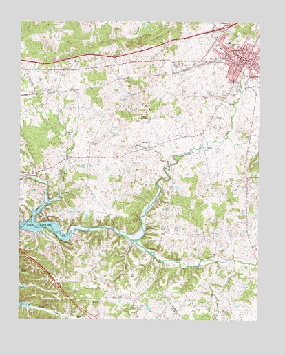
Princeton West, KY USGS Topographic Map
Click on map above to begin viewing in our Map Viewer.

This topographic map contains these locations and features:
Feature Name Type Latitude Longitude GNIS ID View Map
Beck CemeteryCemeteryN37.0781°W87.9633°486641View Map
Big SpringSpringN37.1081°W87.8815°487261View Map
Big Spring BranchStreamN37.0939°W87.8847°487266View Map
Caldwell ChapelChurchN37.0739°W87.9620°488589View Map
Caldwell County Emergency Medical ServicesBuildingN37.1246°W87.8932°2719071View Map
Caldwell County HospitalHospitalN37.1136°W87.9095°2660335View Map
Caldwell County Sheriff's OfficeBuildingN37.1091°W87.8819°2767520View Map
Calvary Baptist ChurchChurchN37.1153°W87.8983°488637View Map
City of PrincetonCivilN37.1068°W87.8853°2404574View Map
Craig CemeteryCemeteryN37.1217°W87.9486°490266View Map
Dry CreekStreamN37.0323°W87.9386°491176View Map
Dry Fork CreekStreamN37.0245°W87.8867°491218View Map
DulaneyPopulated PlaceN37.0970°W87.9806°507886View Map
Eastside SchoolSchoolN37.1075°W87.8786°491521View Map
Eddy Creek Baptist ChurchChurchN37.0355°W87.9076°491551View Map
Freeman-Cash CemeteryCemeteryN37.0600°W87.9803°492513View Map
Friendship ChurchChurchN37.0076°W87.9575°492543View Map
Glass CreekStreamN37.0498°W87.9847°492879View Map
Goose CreekStreamN37.0762°W87.8917°493009View Map
Gromes ChapelChurchN37.0937°W87.9042°493417View Map
Hallaway HillSummitN37.0403°W87.9734°493596View Map
Harpending SpringsSpringN37.0379°W87.9341°493779View Map
Hayes SpringSpringN37.0846°W87.9342°493913View Map
Hilltop Center SchoolSchoolN37.1153°W87.8903°494278View Map
Hollinsworth Post Office (historical)Populated PlaceN37.0681°W87.9739°2743600View Map
Hopewell CemeteryCemeteryN37.0417°W87.9892°494519View Map
Hopewell HillSummitN37.0434°W87.9842°494539View Map
Kilgore CemeteryCemeteryN37.0270°W87.9328°495724View Map
Oliver CemeteryCemeteryN37.0053°W87.9364°499930View Map
Oliver CemeteryCemeteryN37.0289°W87.9558°499931View Map
Pilfer CreekStreamN37.0414°W87.9936°500624View Map
PrincetonPopulated PlaceN37.1092°W87.8820°501350View Map
Princeton Country ClubLocaleN37.0842°W87.8978°517268View Map
Princeton Fire DepartmentBuildingN37.1093°W87.8813°2636702View Map
Princeton Police DepartmentBuildingN37.1098°W87.8811°2767406View Map
Ratliff ParkParkN37.0992°W87.8842°501587View Map
Robertson CreekStreamN37.0270°W87.9436°502075View Map
Rock Spring (historical)Populated PlaceN37.0597°W87.8802°2743606View Map
Rock Spring ChurchChurchN37.0600°W87.8796°502146View Map
Rogers CemeteryCemeteryN37.0225°W87.9233°502275View Map
Saint Pauls SchoolSchoolN37.0950°W87.8889°502719View Map
Sand Hollow CreekStreamN37.0326°W87.9403°502917View Map
SaratogaPopulated PlaceN37.0601°W87.9975°509016View Map
Saratoga SpringSpringN37.0599°W87.9952°502993View Map
Scott BranchStreamN37.0514°W87.9792°503081View Map
Scott CemeteryCemeteryN37.1000°W87.9806°503091View Map
Sebron-Kilgore CemeteryCemeteryN37.0331°W87.9336°503141View Map
South YardLocaleN37.1067°W87.9064°503988View Map
Southside ChurchChurchN37.1023°W87.8786°504008View Map
Spillman ChapelChurchN37.1123°W87.8845°504076View Map
Sweetwater CreekStreamN37.0581°W87.9917°504856View Map
V F W ParkParkN37.0981°W87.8833°505933View Map
Wallace BranchStreamN37.0637°W87.9237°506135View Map
Westside SchoolSchoolN37.1164°W87.8908°506503View Map
Wiley BridgeBridgeN37.0723°W87.9039°506756View Map

Note: Coordinates in the location and feature list above are referenced to NAD83 datum.


Copyright (C) 2008-2024 Ryan Niemi / Sunset Dynamics ... All Rights Reserved