TopoQuest Logo
Do you find TopoQuest useful?
Help keep TopoQuest running and adding new maps/features by donating!
Bitcoin:  19c7KJd3qBynnjoSw5npx9KScwjBe4ifkT
Litecoin:  LXs6TkuXGGXo1vDsWCkWVdjQX94eUKd6ui
Home View Maps Find Maps Find Places Resources & Links


Fredonia, Kentucky Topographic Map

USGS Map Title: Fredonia, KY
USGS Map MRC: 37088B1
DRG (GeoTIFF) Download: o37088b1.tif


Neighboring USGS Topographic Map Quads:


  Salem, KY  
37088C2
 

  Marion, KY  
37088C1
 

  Shady Grove, KY  
37087C8
 

  Dycusburg, KY  
37088B2
 

  Fredonia, KY  
37088B1
 

  Crider, KY  
37087B8
 

  Grand Rivers, KY  
37088A2
 

  Eddyville, KY  
37088A1
 

  Princeton West, KY  
37087A8


Map MRC Location:

N38°
W89°
N38°
W88°
H8 H7 H6 H5 H4 H3 H2 H1
G8 G7 G6 G5 G4 G3 G2 G1
F8 F7 F6 F5 F4 F3 F2 F1
E8 E7 E6 E5 E4 E3 E2 E1
D8 D7 D6 D5 D4 D3 D2 D1
C8 C7 C6 C5 C4 C3 C2 C1
B8 B7 B6 B5 B4 B3 B2 B1
A8 A7 A6 A5 A4 A3 A2 A1
N37°
W89°
N37°
W88°

Fredonia, KY USGS 1:24K Topographic Map Preview:
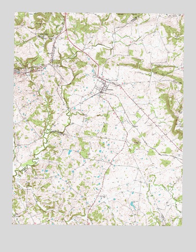
Fredonia, KY USGS Topographic Map
Click on map above to begin viewing in our Map Viewer.

This topographic map contains these locations and features:
Feature Name Type Latitude Longitude GNIS ID View Map
BakersPopulated PlaceN37.1839°W88.0356°507437View Map
Blue MineMineN37.2173°W88.1111°487530View Map
Brewster CreekStreamN37.1484°W88.0236°487869View Map
Campbell CemeteryCemeteryN37.2350°W88.0903°488732View Map
Centerville (historical)Populated PlaceN37.2278°W88.0752°2743666View Map
Centerville Historical MarkerParkN37.2278°W88.0760°2744055View Map
City of FredoniaCivilN37.2086°W88.0603°2403662View Map
Cobb CemeteryCemeteryN37.1481°W88.1142°489749View Map
Crider CemeteryCemeteryN37.2134°W88.0633°490343View Map
Dry ForkStreamN37.1789°W88.0997°491203View Map
Dry Fork Skinframe CreekStreamN37.1301°W88.0720°491220View Map
FredoniaPopulated PlaceN37.2081°W88.0567°492485View Map
Fredonia (historical)Populated PlaceN37.2357°W88.0702°2743688View Map
Fredonia Fire DepartmentBuildingN37.2077°W88.0598°2636798View Map
Fredonia ValleyBasinN37.1614°W88.0511°492486View Map
Fredonia Valley QuarryMineN37.1737°W88.0345°492487View Map
Haffaw MineMineN37.2189°W88.1061°493535View Map
Hebron ChurchChurchN37.1289°W88.1236°493990View Map
Hebron SchoolSchoolN37.1301°W88.1236°493994View Map
Hickory GrovePopulated PlaceN37.1794°W88.0407°2743599View Map
Hill CemeteryCemeteryN37.1842°W88.0231°494245View Map
Horseapple CreekStreamN37.1281°W88.0800°494591View Map
King MineMineN37.2376°W88.1031°495745View Map
LilydalePopulated PlaceN37.2494°W88.0877°2743694View Map
Livingston (historical)Populated PlaceN37.1927°W88.0757°2743602View Map
Livingston CemeteryCemeteryN37.2098°W88.0067°496909View Map
McElroy CreekStreamN37.1395°W88.0042°485692View Map
MexicoPopulated PlaceN37.2251°W88.0967°498091View Map
Mexico SchoolSchoolN37.2351°W88.0964°498092View Map
Mills Bluff CreekStreamN37.1893°W88.0837°2743603View Map
Moore HillSummitN37.2364°W88.0061°498555View Map
New Bethel ChurchChurchN37.1423°W88.0567°499285View Map
Norman CemeteryCemeteryN37.1831°W88.0006°499524View Map
Penn Salt Fluorite MillLocaleN37.2137°W88.1161°500380View Map
Pigmy MinesMineN37.2206°W88.0917°500610View Map
Sinking Fork Livingston CreekStreamN37.2151°W88.0314°503572View Map
Skinframe CreekStreamN37.1545°W88.0203°503606View Map
Skinframe CreekStreamN37.1545°W88.1222°503607View Map
State Penal FarmLocaleN37.1314°W88.0370°517291View Map
Sulphur SpringSpringN37.2374°W88.1024°504749View Map
Sulphur Spring ChurchChurchN37.2351°W88.1028°504757View Map
Sulphur Springs CemeteryCemeteryN37.2434°W88.1042°504768View Map
Tabb Number 1 MineMineN37.2159°W88.1236°517293View Map
The BluffCliffN37.1901°W88.0717°509199View Map
The KnobSummitN37.1859°W88.0020°505125View Map
Western Kentucky Correctional ComplexBuildingN37.1375°W88.0408°2767800View Map

Note: Coordinates in the location and feature list above are referenced to NAD83 datum.


Copyright (C) 2008-2024 Ryan Niemi / Sunset Dynamics ... All Rights Reserved