TopoQuest Logo
Do you find TopoQuest useful?
Help keep TopoQuest running and adding new maps/features by donating!
Bitcoin:  19c7KJd3qBynnjoSw5npx9KScwjBe4ifkT
Litecoin:  LXs6TkuXGGXo1vDsWCkWVdjQX94eUKd6ui
Home View Maps Find Maps Find Places Resources & Links


Lamasco, Kentucky Topographic Map

USGS Map Title: Lamasco, KY
USGS Map MRC: 36087H8
DRG (GeoTIFF) Download: o36087h8.tif


Neighboring USGS Topographic Map Quads:


  Eddyville, KY  
37088A1
 

  Princeton West, KY  
37087A8
 

  Princeton East, KY  
37087A7
 

  Mont, KY  
36088H1
 

  Lamasco, KY  
36087H8
 

  Cobb, KY  
36087H7
 

  Fenton, KY  
36088G1
 

  Canton, KY  
36087G8
 

  Cadiz, KY  
36087G7


Map MRC Location:

N37°
W88°
N37°
W87°
H8 H7 H6 H5 H4 H3 H2 H1
G8 G7 G6 G5 G4 G3 G2 G1
F8 F7 F6 F5 F4 F3 F2 F1
E8 E7 E6 E5 E4 E3 E2 E1
D8 D7 D6 D5 D4 D3 D2 D1
C8 C7 C6 C5 C4 C3 C2 C1
B8 B7 B6 B5 B4 B3 B2 B1
A8 A7 A6 A5 A4 A3 A2 A1
N36°
W88°
N36°
W87°

Lamasco, KY USGS 1:24K Topographic Map Preview:
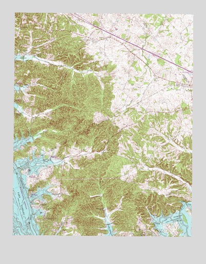
Lamasco, KY USGS Topographic Map
Click on map above to begin viewing in our Map Viewer.

This topographic map contains these locations and features:
Feature Name Type Latitude Longitude GNIS ID View Map
Allen CemeteryCemeteryN36.8900°W87.8856°485853View Map
Baker CemeteryCemeteryN36.9139°W87.9758°486242View Map
Barnett SpringSpringN36.9758°W87.9842°486409View Map
Bethany Missionary Baptist ChurchChurchN36.9785°W87.9949°486932View Map
Black HawkPopulated PlaceN36.9601°W87.8772°507515View Map
Blue Water EstatesPopulated PlaceN36.8914°W87.9784°507537View Map
Boyd CemeteryCemeteryN36.8764°W87.9061°487765View Map
Bush CemeteryCemeteryN36.8995°W87.9022°488488View Map
Cannon Spring Public Use AreaParkN36.9539°W87.9975°488890View Map
Cedar Grove (historical)Populated PlaceN36.9580°W87.9236°2743554View Map
Cherry CemeteryCemeteryN36.8984°W87.8903°489400View Map
Collin CemeteryCemeteryN36.8939°W87.9561°489850View Map
ConfederatePopulated PlaceN36.9920°W87.9975°507743View Map
Confederate BranchStreamN36.9737°W87.9936°489951View Map
Confederate CemeteryCemeteryN36.9778°W87.9942°489952View Map
Critmore CemeteryCemeteryN36.9234°W87.9550°490353View Map
Curlin CemeteryCemeteryN36.9203°W87.8933°490494View Map
Dry Fork CemeteryCemeteryN36.9631°W87.9014°491211View Map
Dryden EstatesPopulated PlaceN36.9428°W87.9956°507877View Map
Goose HollowValleyN36.8885°W87.9773°493022View Map
Gray CemeteryCemeteryN36.9600°W87.9161°493193View Map
Gray CemeteryCemeteryN36.9781°W87.9400°493194View Map
Hall CemeteryCemeteryN36.8903°W87.9320°493572View Map
Hurricane ChurchChurchN36.9228°W87.9370°494817View Map
Hurricane CreekStreamN36.9159°W87.9720°494819View Map
LamascoPopulated PlaceN36.9862°W87.9361°495933View Map
Morse CemeteryCemeteryN36.8981°W87.8914°498635View Map
Muddy Fork Little RiverStreamN36.8853°W87.8831°499043View Map
Oliver CemeteryCemeteryN36.9364°W87.9286°499929View Map
Parker CemeteryCemeteryN36.9909°W87.9220°500189View Map
Piercy CemeteryCemeteryN36.9423°W87.9303°500578View Map
Prizer Point Public Use AreaParkN36.9098°W87.9859°501356View Map
Renaldo (historical)Populated PlaceN36.9766°W87.9163°2743557View Map
RockcastlePopulated PlaceN36.8998°W87.9872°508957View Map
Rockcastle ShoresPopulated PlaceN36.8837°W87.9778°508958View Map
Rolling Mill (historical)Populated PlaceN36.9297°W87.9843°2743559View Map
Siloam ChurchChurchN36.8973°W87.8909°503502View Map
Sivills CemeteryCemeteryN36.9312°W87.8920°503583View Map
Smith CemeteryCemeteryN36.9164°W87.9125°503749View Map
Southeast Lyon DivisionCivilN36.9987°W87.9839°1937265View Map
Standard CemeteryCemeteryN36.9228°W87.9517°504250View Map
Steinbaugh CemeteryCemeteryN36.9850°W87.9542°504328View Map
Stephens CemeteryCemeteryN36.9448°W87.9092°504336View Map
Trigg - Lyon Volunteer Fire DepartmentBuildingN36.8982°W87.9635°2636390View Map
Trigg FurnacePopulated PlaceN36.8901°W87.9361°509234View Map
Twin TreesLocaleN36.8759°W87.9125°505724View Map
Wallace CemeteryCemeteryN36.8781°W87.9653°506136View Map
Wynn CemeteryCemeteryN36.9331°W87.9186°507180View Map

Note: Coordinates in the location and feature list above are referenced to NAD83 datum.


Copyright (C) 2008-2025 Ryan Niemi / Sunset Dynamics ... All Rights Reserved