TopoQuest Logo
Do you find TopoQuest useful?
Help keep TopoQuest running and adding new maps/features by donating!
Bitcoin:  19c7KJd3qBynnjoSw5npx9KScwjBe4ifkT
Litecoin:  LXs6TkuXGGXo1vDsWCkWVdjQX94eUKd6ui
Home View Maps Find Maps Find Places Resources & Links


Dycusburg, Kentucky Topographic Map

USGS Map Title: Dycusburg, KY
USGS Map MRC: 37088B2
DRG (GeoTIFF) Download: o37088b2.tif


Neighboring USGS Topographic Map Quads:


  Lola, KY  
37088C3
 

  Salem, KY  
37088C2
 

  Marion, KY  
37088C1
 

  Burna, KY  
37088B3
 

  Dycusburg, KY  
37088B2
 

  Fredonia, KY  
37088B1
 

  Calvert City, KY  
37088A3
 

  Grand Rivers, KY  
37088A2
 

  Eddyville, KY  
37088A1


Map MRC Location:

N38°
W89°
N38°
W88°
H8 H7 H6 H5 H4 H3 H2 H1
G8 G7 G6 G5 G4 G3 G2 G1
F8 F7 F6 F5 F4 F3 F2 F1
E8 E7 E6 E5 E4 E3 E2 E1
D8 D7 D6 D5 D4 D3 D2 D1
C8 C7 C6 C5 C4 C3 C2 C1
B8 B7 B6 B5 B4 B3 B2 B1
A8 A7 A6 A5 A4 A3 A2 A1
N37°
W89°
N37°
W88°

Dycusburg, KY USGS 1:24K Topographic Map Preview:
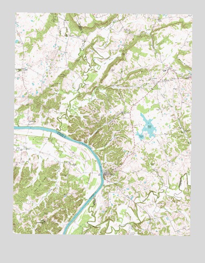
Dycusburg, KY USGS Topographic Map
Click on map above to begin viewing in our Map Viewer.

This topographic map contains these locations and features:
Feature Name Type Latitude Longitude GNIS ID View Map
Asbridge CemeteryCemeteryN37.2178°W88.1811°486066View Map
Axel CreekStreamN37.1953°W88.2103°486164View Map
Billy Al MineMineN37.2139°W88.2153°487314View Map
Boaz SchoolSchoolN37.1937°W88.1725°487595View Map
Bogard SpringSpringN37.1775°W88.1255°487612View Map
Brushy PondLakeN37.1855°W88.1562°488149View Map
Caldwell SpringSpringN37.1836°W88.1303°488595View Map
Caldwell Spring CemeteryCemeteryN37.1845°W88.1292°488596View Map
Caldwell Spring CreekStreamN37.1601°W88.1284°488597View Map
Caldwell Springs Volunteer Fire DepartmentBuildingN37.1962°W88.1321°2636966View Map
City of DycusburgCivilN37.1604°W88.1846°2403522View Map
Claylick CreekStreamN37.1837°W88.2195°489591View Map
Cox Spring BranchStreamN37.2373°W88.2178°490232View Map
Crab CreekStreamN37.1464°W88.1481°490240View Map
Cypress CreekStreamN37.1828°W88.2236°490524View Map
Doan SpringSpringN37.2274°W88.1745°490937View Map
Doan Spring CreekStreamN37.2203°W88.1884°490938View Map
Dry CreekStreamN37.2362°W88.2136°491177View Map
DycusburgPopulated PlaceN37.1595°W88.1845°491380View Map
Dycusburg CemeteryCemeteryN37.1625°W88.1784°491381View Map
Emmus ChurchChurchN37.2453°W88.1795°491772View Map
FrancesPopulated PlaceN37.2198°W88.1411°492431View Map
Grasen MineMineN37.2087°W88.2239°493136View Map
Green MineMineN37.2101°W88.2206°493279View Map
Groves ChapelChurchN37.1645°W88.2084°493440View Map
Groves Chapel CemeteryCemeteryN37.1581°W88.2120°493442View Map
Groves Chapel SchoolSchoolN37.1648°W88.2100°493443View Map
Harp Hollow CreekStreamN37.1723°W88.1934°493777View Map
Hodge MineMineN37.2373°W88.1631°494333View Map
Hulet MineMineN37.2237°W88.2036°494751View Map
James LakeLakeN37.2335°W88.2491°495161View Map
Kelley MineMineN37.2148°W88.2149°495615View Map
Koons CemeteryCemeteryN37.1964°W88.1489°495872View Map
Larping SpringSpringN37.1654°W88.1529°495993View Map
Livingston CreekStreamN37.1467°W88.1925°496913View Map
Maple LakeLakeN37.1855°W88.1562°497514View Map
Mary Helen MineMineN37.2128°W88.1414°497643View Map
Mathews CemeteryCemeteryN37.2081°W88.1350°497677View Map
Nancy Hanks MineMineN37.2462°W88.2236°499163View Map
New Bethel SchoolSchoolN37.1320°W88.2273°499290View Map
Number 18 MineMineN37.2109°W88.1547°517251View Map
Number 21 MineMineN37.2131°W88.1389°517252View Map
Number 22 MineMineN37.2137°W88.1525°517253View Map
Owens CemeteryCemeteryN37.2412°W88.1711°500065View Map
Owens SchoolSchoolN37.2406°W88.1711°500077View Map
Owens School (historical)Populated PlaceN37.2406°W88.1729°2743697View Map
Owens School (historical)Populated PlaceN37.2406°W88.1729°2743698View Map
Paddys CreekStreamN37.1759°W88.1973°500104View Map
Panther CreekStreamN37.1306°W88.1956°500159View Map
PinckneyvillePopulated PlaceN37.1873°W88.2398°500661View Map
Pinckneyville CemeteryCemeteryN37.2178°W88.2447°500662View Map
Pinckneyville ChurchChurchN37.2173°W88.2461°500663View Map
Post Oak RidgeRidgeN37.1537°W88.2298°501172View Map
Puckett SpringSpringN37.2344°W88.2005°501418View Map
Puckett Spring CreekStreamN37.2189°W88.1970°501419View Map
Red MineMineN37.2292°W88.1747°501665View Map
Reiter CornersLocaleN37.2481°W88.1484°501722View Map
Reiter MineMineN37.2409°W88.1570°501723View Map
Seven Branch ChurchChurchN37.1937°W88.1725°503181View Map
Shelbys StoreLocaleN37.2370°W88.2111°503325View Map
Spring CreekStreamN37.1314°W88.1678°504129View Map
Spring Creek (historical)Populated PlaceN37.1290°W88.1552°2743563View Map
Stevenson CemeteryCemeteryN37.2348°W88.1292°504372View Map
TilinePopulated PlaceN37.1726°W88.2445°505281View Map
Tiline CemeteryCemeteryN37.1656°W88.2445°505282View Map
Tuckers Temple ChurchChurchN37.1312°W88.2281°505550View Map
Wadell QuarryMineN37.2370°W88.2056°506091View Map
Whitt BluffCliffN37.2209°W88.1306°506695View Map

Note: Coordinates in the location and feature list above are referenced to NAD83 datum.


Copyright (C) 2008-2025 Ryan Niemi / Sunset Dynamics ... All Rights Reserved