TopoQuest Logo
Do you find TopoQuest useful?
Help keep TopoQuest running and adding new maps/features by donating!
Bitcoin:  19c7KJd3qBynnjoSw5npx9KScwjBe4ifkT
Litecoin:  LXs6TkuXGGXo1vDsWCkWVdjQX94eUKd6ui
Home View Maps Find Maps Find Places Resources & Links


Oakland City, Indiana Topographic Map

USGS Map Title: Oakland City, IN
USGS Map MRC: 38087C3
DRG (GeoTIFF) Download: o38087c3.tif


Neighboring USGS Topographic Map Quads:


  Union, IN  
38087D4
 

  Petersburg, IN  
38087D3
 

  Winslow, IN  
38087D2
 

  Francisco, IN  
38087C4
 

  Oakland City, IN  
38087C3
 

  Augusta, IN  
38087C2
 

  Elberfeld, IN  
38087B4
 

  Lynnville, IN  
38087B3
 

  Folsomville, IN  
38087B2


Map MRC Location:

N39°
W88°
N39°
W87°
H8 H7 H6 H5 H4 H3 H2 H1
G8 G7 G6 G5 G4 G3 G2 G1
F8 F7 F6 F5 F4 F3 F2 F1
E8 E7 E6 E5 E4 E3 E2 E1
D8 D7 D6 D5 D4 D3 D2 D1
C8 C7 C6 C5 C4 C3 C2 C1
B8 B7 B6 B5 B4 B3 B2 B1
A8 A7 A6 A5 A4 A3 A2 A1
N38°
W88°
N38°
W87°

Oakland City, IN USGS 1:24K Topographic Map Preview:
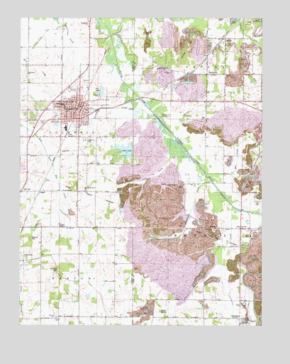
Oakland City, IN USGS Topographic Map
Click on map above to begin viewing in our Map Viewer.

This topographic map contains these locations and features:
Feature Name Type Latitude Longitude GNIS ID View Map
Albright CemeteryCemeteryN38.2537°W87.3558°430045View Map
Bakren DitchCanalN38.3681°W87.2589°430442View Map
Blackfoot ChurchChurchN38.2892°W87.2742°431148View Map
City of Oakland CityCivilN38.3378°W87.3492°2395292View Map
CoePopulated PlaceN38.3064°W87.2581°449045View Map
Coleman CemeteryCemeteryN38.2992°W87.2808°432756View Map
Columbia Township Volunteer Fire DepartmentBuildingN38.3521°W87.3443°2701362View Map
Davis CemeteryCemeteryN38.3334°W87.2811°433344View Map
DongolaPopulated PlaceN38.3720°W87.3403°433632View Map
Enos CornerPopulated PlaceN38.2892°W87.2611°434216View Map
Enos MineMineN38.2864°W87.2558°434217View Map
Friendship ChurchChurchN38.3520°W87.3711°434860View Map
Gibson County Emergency Medical Services Station 2BuildingN38.3388°W87.3464°2719432View Map
Gray JunctionPopulated PlaceN38.3264°W87.3447°435368View Map
GudgelPopulated PlaceN38.3048°W87.3645°435542View Map
Hat CreekStreamN38.3117°W87.2789°435867View Map
Honey CreekStreamN38.2989°W87.2656°436380View Map
Honey SpringSpringN38.2552°W87.2995°436397View Map
Jordan ParkParkN38.2581°W87.2611°437124View Map
Lick CreekStreamN38.3325°W87.3025°437858View Map
MarysvillePopulated PlaceN38.3520°W87.2783°438690View Map
McCullough Grove ChurchChurchN38.3045°W87.3414°438844View Map
McGregors HillMineN38.2725°W87.3161°452144View Map
Montgomery CemeteryCemeteryN38.3256°W87.3414°439361View Map
Moore HillSummitN38.2850°W87.3692°439399View Map
MurenPopulated PlaceN38.3664°W87.2689°439888View Map
New LakeReservoirN38.3209°W87.3209°446902View Map
Oak HillPopulated PlaceN38.3045°W87.3745°440428View Map
Oakland CityPopulated PlaceN38.3387°W87.3450°440470View Map
Oakland City CollegeSchoolN38.3395°W87.3520°440471View Map
Oakland City Country ClubLocaleN38.3323°W87.3547°452375View Map
Oakland City Elementary SchoolSchoolN38.3298°W87.3522°446977View Map
Oakland City Fire DepartmentBuildingN38.3403°W87.3445°2625691View Map
Oakland City JunctionPopulated PlaceN38.3317°W87.3014°440472View Map
Oakland City Police DepartmentBuildingN38.3388°W87.3438°2758049View Map
Old LakeReservoirN38.3452°W87.3332°440574View Map
Old Oakland City Lake DamDamN38.3467°W87.3317°448654View Map
Patoka River National Wildlife RefugeParkN38.3667°W87.3147°2765443View Map
Patoka State Fish and Wildlife AreaParkN38.2556°W87.3125°446901View Map
Potaka Grove ChurchChurchN38.3539°W87.2997°441491View Map
Simpson CemeteryCemeteryN38.2637°W87.2831°443529View Map
Somerville MineMineN38.2900°W87.3667°443768View Map
SpurgeonPopulated PlaceN38.2523°W87.2572°444435View Map
Spurgeon Fire DepartmentBuildingN38.2584°W87.2592°2625648View Map
Town of SpurgeonCivilN38.2553°W87.2587°2397677View Map
Township of ColumbiaCivilN38.3351°W87.3619°453240View Map
Township of MonroeCivilN38.2834°W87.2575°453644View Map
Townsley CemeteryCemeteryN38.2534°W87.3567°444843View Map
Turkey CreekStreamN38.3414°W87.3136°444960View Map
Turkey HillSummitN38.3617°W87.2897°444973View Map
Union CemeteryCemeteryN38.3073°W87.2928°445050View Map
Waldo J Wood Memorial High SchoolSchoolN38.3298°W87.3522°446978View Map
Wheeler CreekStreamN38.3139°W87.2820°445885View Map
Williams CemeteryCemeteryN38.3537°W87.2983°446059View Map
Wilson HillSummitN38.2739°W87.3575°446148View Map
Wirth ParkParkN38.3323°W87.3631°446205View Map

Note: Coordinates in the location and feature list above are referenced to NAD83 datum.


Copyright (C) 2008-2024 Ryan Niemi / Sunset Dynamics ... All Rights Reserved