TopoQuest Logo
Do you find TopoQuest useful?
Help keep TopoQuest running and adding new maps/features by donating!
Bitcoin:  19c7KJd3qBynnjoSw5npx9KScwjBe4ifkT
Litecoin:  LXs6TkuXGGXo1vDsWCkWVdjQX94eUKd6ui
Home View Maps Find Maps Find Places Resources & Links


Elberton West, Georgia Topographic Map

USGS Map Title: Elberton West, GA
USGS Map MRC: 34082A8
DRG (GeoTIFF) Download: o34082a8.tif


Neighboring USGS Topographic Map Quads:


  Bowman, GA  
34083B1
 

  Dewy Rose, GA  
34082B8
 

  Rock Branch, GA  
34082B7
 

  Carlton, GA  
34083A1
 

  Elberton West, GA  
34082A8
 

  Elberton East, GA  
34082A7
 

  Sandy Cross, GA  
33083H1
 

  Vesta, GA  
33082H8
 

  Jacksons Crossroads, GA  
33082H7


Map MRC Location:

N35°
W83°
N35°
W82°
H8 H7 H6 H5 H4 H3 H2 H1
G8 G7 G6 G5 G4 G3 G2 G1
F8 F7 F6 F5 F4 F3 F2 F1
E8 E7 E6 E5 E4 E3 E2 E1
D8 D7 D6 D5 D4 D3 D2 D1
C8 C7 C6 C5 C4 C3 C2 C1
B8 B7 B6 B5 B4 B3 B2 B1
A8 A7 A6 A5 A4 A3 A2 A1
N34°
W83°
N34°
W82°

Elberton West, GA USGS 1:24K Topographic Map Preview:
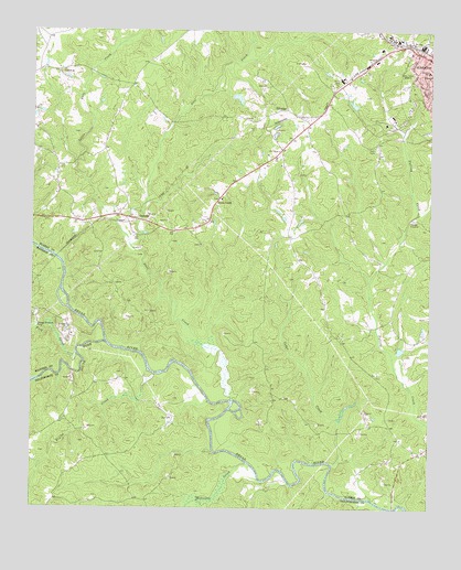
Elberton West, GA USGS Topographic Map
Click on map above to begin viewing in our Map Viewer.

This topographic map contains these locations and features:
Feature Name Type Latitude Longitude GNIS ID View Map
Antioch CemeteryCemeteryN34.1145°W82.9899°347789View Map
Antioch ChurchChurchN34.1148°W82.9904°354365View Map
Cedar CreekStreamN34.0115°W82.9049°312451View Map
Central SchoolSchoolN34.1140°W82.8771°312532View Map
Coggins LakeReservoirN34.1058°W82.8992°339011View Map
Coggins Lake DamDamN34.1051°W82.8982°339010View Map
Deadwylers Ferry (historical)CrossingN34.0432°W82.9763°347817View Map
Detwiler Ferry (historical)CrossingN34.0643°W82.9907°347819View Map
Dove CreekPopulated PlaceN34.0798°W82.9421°355536View Map
Dove CreekStreamN34.0284°W82.9365°355537View Map
Dove Creek CemeteryCemeteryN34.0804°W82.9412°347823View Map
Dove Creek ChurchChurchN34.0809°W82.9407°334658View Map
Dove Creek School (historical)SchoolN34.0898°W82.9218°334659View Map
Doves Creek Elementary SchoolSchoolN34.1093°W82.8958°2545508View Map
Elbert County Comprehensive High SchoolSchoolN34.1079°W82.8848°347829View Map
Elbert County Middle SchoolSchoolN34.1065°W82.8942°347833View Map
EthridgePopulated PlaceN34.1043°W82.9199°331671View Map
Fork CreekStreamN34.0401°W82.9860°314276View Map
Jones Ferry (historical)CrossingN34.0084°W82.9199°335760View Map
Jones Street School (historical)SchoolN34.1148°W82.8796°347870View Map
Kegles CreekStreamN34.0351°W82.9610°316340View Map
Kingdom HallChurchN34.0943°W82.8951°347871View Map
Limo Church (historical)ChurchN34.0768°W82.9013°347872View Map
Little Dove CreekStreamN34.0690°W82.9688°317059View Map
Martins Ferry (historical)CrossingN34.0415°W82.9715°335768View Map
Mattox BridgeBridgeN34.0004°W82.8857°347875View Map
Mill BranchStreamN34.0146°W82.9421°335774View Map
Millstone CreekStreamN34.0118°W82.9318°318289View Map
OglesbyPopulated PlaceN34.0757°W82.9671°332560View Map
Rome Kraft LakeReservoirN34.1074°W82.9356°339013View Map
Rome Kraft Lake DamDamN34.1084°W82.9365°339012View Map
Saint Mary Catholic ChurchChurchN34.1096°W82.8754°347901View Map
Samuel Elbert AcademySchoolN34.1018°W82.8863°347904View Map
South Fork Broad RiverStreamN34.0429°W82.9763°323243View Map
Union Grove Church (historical)ChurchN34.0154°W82.8863°347916View Map
West End ChurchChurchN34.1193°W82.8815°347922View Map
WWRK-AM (Elberton)TowerN34.1126°W82.8810°352441View Map
WWRK-FM (Elberton)TowerN34.0293°W82.9210°352685View Map

Note: Coordinates in the location and feature list above are referenced to NAD83 datum.


Copyright (C) 2008-2025 Ryan Niemi / Sunset Dynamics ... All Rights Reserved