TopoQuest Logo
Do you find TopoQuest useful?
Help keep TopoQuest running and adding new maps/features by donating!
Bitcoin:  19c7KJd3qBynnjoSw5npx9KScwjBe4ifkT
Litecoin:  LXs6TkuXGGXo1vDsWCkWVdjQX94eUKd6ui
Home View Maps Find Maps Find Places Resources & Links


Sandy Cross, Georgia Topographic Map

USGS Map Title: Sandy Cross, GA
USGS Map MRC: 33083H1
DRG (GeoTIFF) Download: o33083h1.tif


Neighboring USGS Topographic Map Quads:


  Danielsville South, GA  
34083A2
 

  Carlton, GA  
34083A1
 

  Elberton West, GA  
34082A8
 

  Crawford, GA  
33083H2
 

  Sandy Cross, GA  
33083H1
 

  Vesta, GA  
33082H8
 

  Maxeys, GA  
33083G2
 

  Lexington, GA  
33083G1
 

  Rayle, GA  
33082G8


Map MRC Location:

N34°
W84°
N34°
W83°
H8 H7 H6 H5 H4 H3 H2 H1
G8 G7 G6 G5 G4 G3 G2 G1
F8 F7 F6 F5 F4 F3 F2 F1
E8 E7 E6 E5 E4 E3 E2 E1
D8 D7 D6 D5 D4 D3 D2 D1
C8 C7 C6 C5 C4 C3 C2 C1
B8 B7 B6 B5 B4 B3 B2 B1
A8 A7 A6 A5 A4 A3 A2 A1
N33°
W84°
N33°
W83°

Sandy Cross, GA USGS 1:24K Topographic Map Preview:
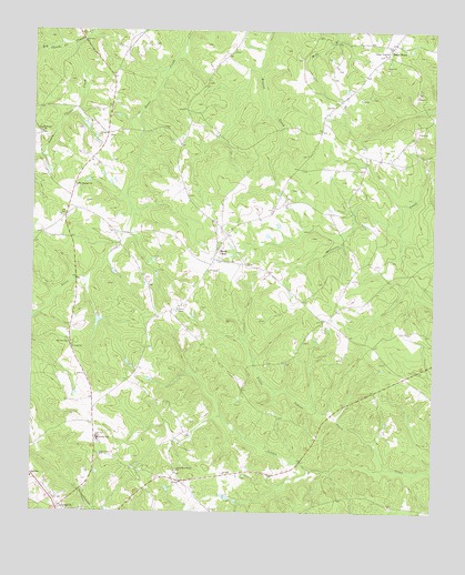
Sandy Cross, GA USGS Topographic Map
Click on map above to begin viewing in our Map Viewer.

This topographic map contains these locations and features:
Feature Name Type Latitude Longitude GNIS ID View Map
Anon Grove ChurchChurchN33.8896°W83.1029°310546View Map
Bethelhem-Brown ChurchChurchN33.8857°W83.0790°354647View Map
Bethlehem Primitive Baptist ChurchChurchN33.9568°W83.0454°335728View Map
Big Clouds CreekStreamN33.9962°W83.1124°311354View Map
Bray CemeteryCemeteryN33.9179°W83.0890°335730View Map
Clouds Creek ChurchChurchN33.9734°W83.1224°355196View Map
Cunningham CemeteryCemeteryN33.9537°W83.0504°335742View Map
Dam Number SixReservoirN33.9757°W83.1162°338563View Map
Echols MillLocaleN33.9679°W83.0051°335749View Map
Glade ChurchChurchN33.9940°W83.0143°356024View Map
Glade ChurchChurchN33.9943°W83.0151°356025View Map
Glade Volunteer Fire DepartmentBuildingN33.9986°W83.0117°2604955View Map
Hardman CemeteryCemeteryN33.9866°W83.0707°335755View Map
Jarrell - Howard CemeteryCemeteryN33.9726°W83.1016°335758View Map
Little Clouds CreekStreamN33.9965°W83.1124°316992View Map
Little Indian CreekStreamN33.8865°W83.0140°317096View Map
Matthews CemeteryCemeteryN33.9343°W83.0343°335769View Map
McCannon CemeteryCemeteryN33.9218°W83.0082°335770View Map
Mount Olive ChurchChurchN33.9190°W83.1132°318773View Map
Mount Pleasant ChurchChurchN33.9596°W83.1110°318859View Map
Noell CemeteryCemeteryN33.9137°W83.0518°335779View Map
Oglethorpe CountyCivilN33.8806°W83.0807°351262View Map
Oglethorpe County Elementary SchoolSchoolN33.8914°W83.1033°335781View Map
Oglethorpe County JailBuildingN33.8949°W83.1213°2733962View Map
Oglethorpe County Primary SchoolSchoolN33.8939°W83.1039°2545554View Map
Oglethorpe County Sheriff's OfficeBuildingN33.8948°W83.1214°2733763View Map
Paul and Lester CemeteryCemeteryN33.9947°W83.0653°335785View Map
Point PeterPopulated PlaceN33.9959°W83.0132°332718View Map
Saint Pauls ChurchChurchN33.9182°W83.1126°322284View Map
Sandy CrossPopulated PlaceN33.9432°W83.0665°332971View Map
Sandy Cross Baptist ChurchChurchN33.9448°W83.0674°335794View Map
Sandy Cross Volunteer Fire DepartmentBuildingN33.9442°W83.0623°2604801View Map
South Fork Broad River Number One DamDamN33.9251°W83.1049°336470View Map
South Fork Broad River Number Six DamDamN33.9784°W83.1132°338562View Map
Tiller CemeteryCemeteryN33.9193°W83.0404°335798View Map
Watkins CemeteryCemeteryN33.9248°W83.0346°335802View Map

Note: Coordinates in the location and feature list above are referenced to NAD83 datum.


Copyright (C) 2008-2024 Ryan Niemi / Sunset Dynamics ... All Rights Reserved